Stratigraphy of the Rocky Mountain Front
Author: Sarah Anne Devaney, Department of Earth Sciences, Montana State University
![[reuse info]](/images/information_16.png)
-
Precambrian Rocks --The northern Rocky Mountains are underlain by the Mesoproterozoic Belt Basin (deposition began ca. 1500 million years ago), and include the Spokane and Empire Formations, Helena Dolomite, Snowslip Formation, Shepard Formation, Mount Shields Formation, Bonner Quartzite and McNamara Formation. Most of these units are clastic shales, argillites, siltstones and quartzites except for the carbonate Helena Dolomite. These units of the Belt Basin are only exposed in the western part of the area, but Glacier Park to the north is largely underlain by Belt sedimentary rocks. No Archean rocks of the Medicine Hat Block or Paleoproterozoic rocks of the Great Falls Tectonic Zone are exposed in this area. The following images show sedimentary structures, mud cracks and ripple marks, that indicate a shallow water environment of deposition.
 Hidden Lake, Glacier National Park, Montana, is nestled in the high mountains, and runoff from the steep slopes of surrounding landscape helps to keep the lake full. Credit: Lisa McKeon, USGS

![[creative commons]](/images/creativecommons_16.png)

-
Paleozoic Rocks--These sedimentary rocks are largely of shallow marine origin and include:
 MBMG Earth History Table
- Cambrian Flathead Sandstone and shales and limestones (Gordon Shale, Damnation Limestone, Dearborn Limestone, Pagoda Limestone, Steamboat Limestone, Switchback Shale, and Devils Glen Dolomite);
- Devonian Maywood Formation (siltsone and limestone), Jefferson Dolomite and Three Forks Formations (limestone and carbonaceous shale and evaporitic solution breccias);
- Mississippian Madison Group (lower section Allan Mountain Limestone, equivalent to Lodgepole Limestone, and upper section Castle Reef Limestone equivalent to Mission Canyon Limestone)
-
Mesozoic Rocks --These sedimentary rocks are Jurassic to Cretaceous in age, and and are dominantly mudstone with some sandstone of marine to non-marine origin.
 Diversion Dam
- Middle and Upper Jurassic rocks include the Ellis Group that are of marine origin (Sawtooth Formation--sandstone, shale and siltstone; Rierdon Formaion--gray mudstone, siltstone, shale; Swift Formation--shale and sandstone);
- Morrison Formation--a Jurassic non marine mudstone with some sandstone;
- Kootenai Formation--the oldest Cretaceous unit in the area consists of variegated mudstones and sandstones.
- Colorado Group includes the Blackleaf Formation (bentonitic shales mudstones) and Marias River Shale (dark gray calcareous and non-calcareous shales)
- Montana Group includes the Telegraph Creek Formation (sandstones and sandy shales with some ripple marks and crossbeds), Virgelle Sandstone (thinly bedded standsones with cross beds), and Two Medicine Formation the youngest Upper Cretaceous unit exposed in the Sun River Canyon area (mudstone interbedded with sandstone, locally tuffaceous and carbonaceous). The Two Medicine Formation is host to the famous Egg Mountain dinosaur site described in our Paleontology module.

When traveling east to west across the Rocky Mountain Front, you might notice that the individual rock units get thicker, most noticeably so the rocks from the Precambrian Belt Supergroup (primarily fine-grained sedimentary rocks with rare igneous intrusions): from 5,300-7,500 ft. (1,770-2,500 m) in the east to roughly 25,000 ft. (8,300 m) in the west. But that is not the only characteristic that changes from east to west. Sedimentary facies change as well. For example, the eastern part of the Cambrian Steamboat Limestone has very similar amounts of mudstone and limestone, but the western part contains mainly limestone. There are also several unconformities as well as disconformities, some might have had a role in the structural development.
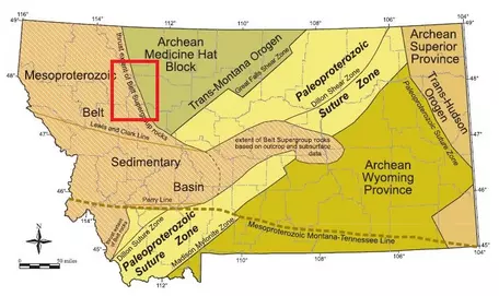
Our described area lies in the south part of the Disturbed Belt which goes all the way up into Alberta. Explore our page on Structural Geology for more on its role. The edge of the Disturbed Belt coincides with the edge of the Belt Supergroup which can best be seen further to the south in the Wolf Creek Canyon along Interstate 15, in Glacier National Park and in western Montana. Not just because of its thickness is this group truly "super" but its 77,220 sq.mi (200,000 km²) extends into Montana (see figure), Idaho, British Columbia, Alberta (in Canada it is called the Purcell Supergroup) and northeastern Washington.
Precambrian Belt Supergroup -- Ancient Evidence of Life
The Belt/Purcell Supergroup formed on the basement of the super-continent Columbia/Nuna (which dates back to 2,500 to 1,500 million years ago). This ancient continental crust began to break apart by rifting (extensional faulting), which caused the Belt Basin to form about 1500 million years ago. There is still some controversy concerning whether this basin had a marine or lacustrine environment of deposition. This landscape was home to stromatolites which can be found in fossilized form in Glacier National Park. Stromatolites are sedimentary structures that form by binding or precipitating minerals as a result of growth and metabolic activity of bacterial microorganisms (predominantly blue-green algae). Stromatolites often form planar structures following the formation of microbial mats along the margins of shallow, warm seas. Modern analogues can be found in the Bahamas or at Shark Bay, Australia. NASA is currently researching these fascinating organisms to find parallel environments on other planets.


Paleozoic Marine Sedimentary Rocks
During the Paleozoic Era (542-252 million years ago) most of Montana was a shallow sea with its sediments covering up the Belt formations, in some places they reach several thousand feet in depth. Other parts of the state formed little islands in the sea. Each environment hosted different forms of life. These fossils help with the identification of the environments. For example, these crinoids lived in a shallow, warm sea similar to the modern day setting of the Bahama Islands. The shallow sea's evidence is given by the deposition of shale, limestone, and dolomite.


Mesozoic Rocks--Transition from Marine to Terrestrial Sediments
The following Era is called the Mesozoic (252-66 million years ago) and is known as the Era of the dinosaurs. Check out our paleontology page for more information on the landscapes and their inhabitants.
Every sedimentary environment produces its own set of sedimentary structures. Here are some examples that you might encounter here or elsewhere when traveling through areas with sedimentary rocks.


For more information and much more detail on the individual units and formations of the Rocky Mountain Front you can download these papers:
Richard B. Berg's Geologic Map with unit descriptions
Stratigraphic Column by Melville R. Mudge
A guide on how to study sedimentary rocks can be found at Exploring the Upper Cretaceous Hell Creek Formation Montana: Through the Eyes of a Stratigrapher written by Jen Aschoff. This has examples of description of sedimentary rocks, generating and testing hypotheses, and interpreting "the Big Picture" comparing data, methods and interpretations.
Rock Formations along the Roads
The following list of the most common rock formations you will encounter (sorted by each road log from our Structural Geology page) is an adaptation of Mudge (1972) and Berg (2007) which are linked on this page and provide much more information. When reading the lists and comparing to the order you encounter the units and formations you can get an idea of the stratigraphic separation, tectonic forces and the geologic time it took to build these contacts.