Initial Publication Date: April 10, 2018
Augusta-Choteau Geographic Setting
×
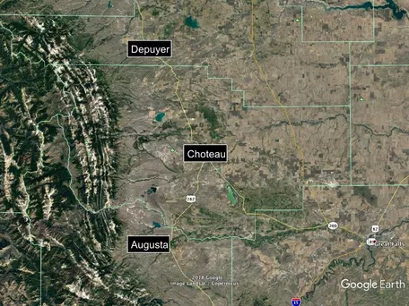
Google Earth Map of Augusta-Choteau area![[creative commons]](/images/creativecommons_16.png)
County Information

×
China Wall Bob Marshall Wilderness Area![[reuse info]](/images/information_16.png)
Geographic, Socio-Economic Indicators from Headwaters Economics
See the report on Montana's Rock Mountain Front by Chris Mehl (2012), Headwaters Economics, that contains extensive historical, demographic and economic (agricultural, land use, hunting and outdoor recreation, and much more) information about this area.
Headwaters Economics has developed an Economic Profile System that produces "socioeconomic reports of communities, counties, & states, including aggregations and comparisons. The Economic Profile System (EPS) uses federal data sources, including the Bureaus of Economic Analysis, Census, & others." Explore the geographies of the of the Rocky Mountain Front by exploring these topical reports for each county.
Teton County
- Profile of Socioeconomic Measures Teton County, MT (Acrobat (PDF) 803kB Apr10 18)
- Profile of Land Use, Teton County, MT (Acrobat (PDF) 374kB Apr10 18)
- Profile of Public Land Amenities, Teton County, MT (Acrobat (PDF) 477kB Apr10 18)
- Profile of Agriculture, Teton County, MT (Acrobat (PDF) 504kB Apr10 18)
- Profile of Mining Including Oil and Gas, Teton County, MT (Acrobat (PDF) 410kB Apr10 18)
- Profile of Timber and Wood Products, Teton County, MT (Acrobat (PDF) 413kB Apr10 18)
- Profile of Tourism, Teton County, MT (Acrobat (PDF) 470kB Apr10 18)

×
Image of Allen Mountain in the Sun River Game Range. There is a field and treed hills in the foreground leading up to the Allan Mountains which are rocky and dotted with cliff faces.
Pondera County
- [Profile of Socioeconomic Indicators Pondera County, MT (Acrobat (PDF) 805kB Apr10 18)
- Profile of Land Use, Pondera County, MT (Acrobat (PDF) 374kB Apr10 18)
- Profile of Public Land Amenities, Pondera County, MT (Acrobat (PDF) 478kB Apr10 18)
- Profile of Agriculture, Pondera County, MT (Acrobat (PDF) 504kB Apr10 18)
- Profile of Mining Including Oil and Gas, Pondera County, MT (Acrobat (PDF) 412kB Apr10 18)
- Profile of Timber and Wood Products, Pondera County, MT (Acrobat (PDF) 412kB Apr10 18)
- Profile of Tourism, Pondera County, MT (Acrobat (PDF) 469kB Apr10 18)
Lewis and Clark County
- Profile of Socioeconomic Indicators Lewis and Clark County, MT (Acrobat (PDF) 809kB Apr10 18)
- Profile of Land Use, Lewis and Clark County, MT (Acrobat (PDF) 375kB Apr10 18)
- Profile of Public Land Amenities, Lewis and Clark County, MT (Acrobat (PDF) 480kB Apr10 18)
- Profile of Agriculture, Lewis and Clark County, MT (Acrobat (PDF) 506kB Apr10 18)
- rofile of Mining Including Oil and Gas, Lewis and Clark County, MTfile of Mining Including Oil and Gas, Lewis and Clark County, MT (Acrobat (PDF) 412kB Apr10 18)
- Profile of Timber and Wood Products, Lewis and Clark County, MT (Acrobat (PDF) 415kB Apr10 18)
- Profile of Tourism, Lewis and Clark County, MT (Acrobat (PDF) 475kB Apr10 18)
Public Lands
×
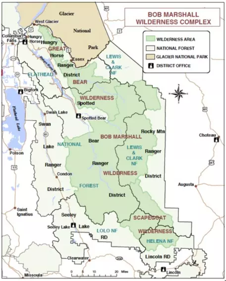
Map of the Bob Marshall Wilderness Area
- Flathead National Forest, see also Special Places ( This site may be offline. )
- Helena-Lewis and Clark National Forest
- See also resources from the Bob Marshall Wilderness Foundation; download their Bob Marshall Wilderness Complex Map (Acrobat (PDF) 293kB Apr10 18)
- The Public Lands Information Center can help you find a Montana BLM 1:100,000 Surface Management Map.
- Public-Private Land Ownership Maps can be downloaded from the Montana State Library.