
Short Course: Teaching in the field with SfM and RTK GPS/GNSS
GETSI Field Virtual Short Course
May 17-21, 2021
Typical daily time: 6-8am Hawaii | 9-11am PT | 10am-12pm MT | 11am-1pm CT | 12-2pm ET and
11am-12pm Hawaii | 2-3pm PT | 3-4pm MT | 4-5pm CT | 5-6pm ET (see Agenda for details)
![[reuse info]](/images/information_16.png)
Teaching materials are drawn from the free online NSF-funded GETSI modules:
- High Precision Positioning with Static and Kinematic GPS/GNSS
- Analyzing High Resolution Topography with TLS and SfM
Vision
Fieldwork is an integral part of the geosciences and there is a longstanding tradition of teaching field methods as part of the undergraduate curriculum. As Earth science research technologies have grown, there is more interest in introducing geodetic methods into field education courses. Technology integration into field education has several advantages, including student engagement and workforce development. This short course has been developed in response to community interest and input and builds on successful pioneering efforts of UNAVCO community members.
Participants
 Students taking pictures for SfM on an outcrop near Kathmandu.
![[creative commons]](/images/creativecommons_16.png)
Participants in this course are a subset of those accepted for the in-person short course originally scheduled for May 2020 but now postponed to May 2022 due to the pandemic (Change Detection with SfM and GPS: Teaching Undergraduates in the Field), as well as some additional teaching colleagues and students of the primary participants. They have all expressed a desire to teach field geodesy methods sooner and not have to wait until the end of the 2021-22 academic year to gain these skills. Attendance was limited to the number of available GNSS receiver pairs (base and rover) that could be sent out for people to work with hands-on.
Goals
Participants will be able to:
- Create a georeferenced SfM point cloud (this requires being able to successfully do both SfM and GPS surveys). (Ideally this would be applied to a geoscience research question but if that is not practical in a particular location during the short course, at least participants will know how they would do it.)
- Develop a geodesy field teaching implementation plan
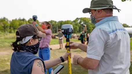
Instructors
 Participants and instructors in a geodesy field teaching short course held by UNAVCO.
- Benjamin Crosby (Idaho State University)
- Bruce Douglas (Indiana University)
- Beth Pratt-Sitaula (UNAVCO)
Sponsors
- NSF -funded GEodesy Tools for Societal Issues (GETSI)
- National Association of Geoscience Teachers (NAGT)
Questions
Contact Beth Pratt-Sitaula (prattsitaula AT unavco.org)
Meeting Information
Participant Workspace (private)