
Hazard Cascade Systems Modeling
Summary

This assignment is designed to help students expand their understanding of hazards as isolated events – to interconnected components of a complex system. Students learn terminology and process for creating dynamic systems models, a tool for visualizing complex relationships between factors in a system. Then, they create their own land surface hazard systems models to illustrate some of the complex interactions dictating impacts and outcomes of natural disasters. Students reflect on how qualitative visual models such as systems maps may be related to quantitative models used for predicting outcomes.
This activity can be used individually or in conjunction with other land surface hazard activities:
- https://serc.carleton.edu/teachearth/activities/311552.html
- https://serc.carleton.edu/teachearth/activities/312255.html
Development of this resource was supported by the Center for Land Surface Hazards (CLaSH) - NSF Award ID #2224871.
Any opinions, findings, and conclusions or recommendations expressed are those of the author(s) and do not necessarily reflect the views of CLaSH and/or the NSF.
 Collapse
Context
Audience
Introductory undergraduate geoscience or geohazards courses; introduction to surface processes course.
![[reuse info]](/images/information_16.png)
Skills and concepts that students must have mastered
Students should have a working knowledge of hazards, including definitions and some factors that may influence the magnitude or timing of hazards. Ideally, students have already completed more in-depth learning on specific hazards (e.g., mass wasting and/or flooding), so that the primary role of this lesson is to help students recognize the overlap between the factors important to each hazard and complexities in predicting hazard outcomes. (If your students need additional background in hazards, some readings are in References below.)
How the activity is situated in the course
This activity is typically done midway through the semester, after students have learned about several hazards in isolation. It can be used as a precursor to exercises in which students utilize simple models to predict outcomes after hazard events.
Goals
Content/concepts goals for this activity
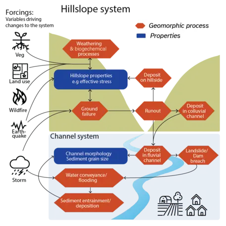
Students describe hazard cascades in which surface hazards alter landscapes in ways which affect the likelihood of other hazards.
Students differentiate between positive and negative feedbacks and explain hazard cascades based on the interactions of systems factors.
Higher order thinking skills goals for this activity
Students develop visual models of hazard systems, illustrating causal relationships, directionality, and complex systems interactions.
Skills goals for this activity
Students provide feedback on each other's models and work in teams to increase the complexity of their systems models. They synthesize what they know about surface hazards to build a complex model that can describe the system as a whole.
Description and Teaching Materials
The instructor presents an interactive slide deck that walks students through the creation of systems models, including how to represent factors, causality and directionality.
- Factors are the systems components included in the model,
- Causality links factors by illustrating which factors affect others, and
- Directionality indicates how factors affect others by indicating positive or negative correlation.
Throughout the slide deck, students are asked to participate by answering discussion questions and completing questions included in the Student Handout. The interactive slides include built-in stopping points for where students should begin working on different parts of the student handout.
Part 1 questions are designed to scaffold learners toward constructing a systems model.
Part 2 gives students the opportunity to build a systems model, including collaborative work in which students provide feedback on each other's models and work together to increase the complexity of the models through creating branches (factors that act as causal factors or effect factors for more than one other system factor), chains (sequences of factors connected by at least three arrows in the same direction), and feedbacks (a closed chain of arrows in which a factor acts as both cause and effect in the same circuit).
Part 3 gives students the opportunity to reflect on how dynamic systems modeling is helpful in framing their understanding of land surface hazards. These questions encourage students to interpret their systems models in words, identify where human impacts may appear, and reflect on how qualitative systems modeling relates to predictive quantitative modeling.
Slides: Updated- Systems Modeling slides.pptx (PowerPoint 2007 (.pptx) 1.5MB Jul14 26)
Student Handout: Systems Model Student Handout (Acrobat (PDF) 437kB Jul14 26)
Teaching Notes and Tips
Instructors should introduce dynamic systems modeling as a tool that helps students recognize the complexity of Earth systems and a mechanism for simplifying that system to clarify relationships between factors. The slides build a dynamic systems model step-by-step, and questions ask students to build a model gradually so that the instructor can choose how much guidance students need.
To scaffold this lesson for novice learners, the instructor may want to walk students through Part 1 of the activity sheet, or have students use the exact same examples shown in the lecture slide to fill out Part 1 of the student worksheet, using it more like guided notes than an independent application activity. In this scenario, the instructor may want to make the entirety of Parts 2 and 3 of the student activity group work.
Pausing class for students to check in with the instructor and each other during Part 1 and incorporating discussions in which the instructor asks for students to give examples of feedbacks as a formative assessment prior to moving to the more complete, more complicated model has also been helpful.
This lesson can be adapted for more advanced students as well. For example, it could be used in an advanced class in conjunction with a computer model to help students predict and understand how and why changing the values of assumed values in the model, e.g. frictional coefficients, results in the outputs observed in the model.
My students create models by hand and submit PDFs via gradescope. Some students prefer to use drawing software on their ipads or devices. Students can use software to build their systems models, such as Google Slides or systems-specific software such as Model Builder,Lucid Chart, Sage Modler, etc.
Assessment
Formative assessment can be collected via class and individual discussion and general monitoring of student progress during the activity. We recommend the extensive use of discussion and formative assessment questions for introductory courses.
Students are graded based on the models they generate. All questions are graded on a good faith completion basis. Models are graded to ensure students have accurately illustrated causality and directionality between their chosen factors, and that they are able to describe complex relationships between factors by incorporating feedbacks, chains, and/or branches within their diagrams. Suggested grading criteria are included in the Student Handout, but grading weights can be altered based on the format of your classroom activities.
References and Resources
A lesson plan on numeric modeling with STELLA can be a good complement to this resource: https://serc.carleton.edu/integrate/teaching_materials/earth_modeling/unit1.html
Background reading and more lesson plans on modeling in Earth Science can be found here:
https://serc.carleton.edu/integrate/teaching_materials/earth_modeling/student_materials/unit1_article1.html
General references on hazards if your students need more background content
- Videos: Natural Hazards: Crash Course Geography #27
- Readings:
- Hazards, Disasters, and Risks: https://pmc.ncbi.nlm.nih.gov/articles/PMC7123175/
- Teaching Engineering: Naturally Disastrous: https://www.teachengineering.org/lessons/view/cub_natdis_lesson01https://books.lib.uoguelph.ca/canadiannaturalhazardsclimatechange/chapter/1-5-2/
- Vulnerability to Natural Hazards: https://courses.ems.psu.edu/geog30/node/379
Creation of the dynamic systems modeling was based the lesson described here:
Fan, N., Sadler, T. D., Kirk, E. A., Ke, L., Elsner, J. N., & Lesnefsky, R. R. (2026). Socio-Scientific System Modeling: Helping Undergraduates Perceive Complexity of Socio-Scientific Issues. Journal of College Science Teaching, 55(1), 41–49. https://doi.org/10.1080/0047231X.2025.2513315
Cascading land surface hazard science is described here:
Yanites, B.J., Clark, M.K., Roering, J.J., West, A.J., Zekkos, D., Baldwin, J.W., Cerovski-Darriau, C., Gallen, S.F., Horton, D.E., Kirby, E., Leshchinsky, B.A., Mason, H.B., Moon, S., Barnhart, K.R., Booth, A., Czuba, J.A., McCoy, S., McGuire, L., Pfeiffer, A., & Pierce, J. (2025) Cascading Land Surface Hazards as a Nexus in the Earth System. Science 388(6754). https://doi.org/10.1126/science.adp9559