
Unit 1.1-SfM/GNSS: Structure from Motion with UAV, GNSS and ground control points (GCPs)
Summary
In this unit, students learn how to design and conduct a Structure from Motion (SfM) survey with ground control points (GCPs). Photos are collected with an uncrewed aerial vehicle (UAV). The survey is geoferenced using real-time kinematic global navigation satellite system (RTK GNSS) instruments. The photos are processed using Agisoft Metashape software to build a variety of 3D models (point clouds, etc.), which students can analyze to address a geologic research question. A wide variety of societally valuable potential science topics are suggested.
SfM is a photogrammetric method that constructs 3D models using overlapping photos. SfM applications are widespread and commonly used in numerous subdisciplines in Earth Science. RTK GNSS techniques allow rapid collection of high-accuracy and high-precision (±2 cm) position information. Combining SfM and RTK GNSS is commonly used to locate SfM models precisely and for temporal surveys in the exact location for surface change detection.
Learning Goals
![[creative commons]](/images/creativecommons_16.png)
- Design and conduct a combined SfM-GNSS survey considering site-specific characteristics and science objectives, including:
- List the equipment needed for an SfM UAV survey with GCPs.
- List and carry out the steps needed to conduct a UAV-platform SfM survey with GCPs (survey workflow).
- Use best practices in designing layout, distributing, and surveying GCP targets.
- Make supporting field notes and observations required for survey analysis and interpretation.
- Process SfM photos with GCPs to generate 3D models, including point clouds, digital elevation models, and orthomosaics, that can be used to address a geoscience research question (model workflow).
Context for Use
This unit is designed for upper-level undergraduate and graduate students in the geosciences, civil engineering, or related fields. It is designed for small-to-medium-sized classes (~5-20 students) with an instructor and, ideally, a teaching assistant for larger classes. It is appropriate for academic year courses with field components or a component of a summer field camp.
This is a more advanced unit that links components of GETSI's field modules High Precision Positioning with Static and Kinematic GPS and Analyzing High Resolution Topography with TLS and SfM. This unit assumes completion of Unit 1: GPS/GNSS Fundamentals andUnit 2: Kinematic GPS/GNSS Methods in the GPS module and builds on Unit 1-SfM: Introduction to SfM in this module. Students should be confident working with kinematic GNSS instrumentation.
The unit requires ~20 minutes for the initial lecture, ~40 minutes for in-class survey pre-planning and class discussion, and ~2-3 hours for field survey planning and implementation. Post-survey data processing should take ~3 hours with teaching materials provided. If implemented during the academic year, it is recommended that this activity be divided into three sessions: introduction and planning (in-class and field), survey and data collection (in the field), and data processing and analysis (in a computer lab or with student laptops).
Description and Teaching Materials
This unit can be adapted to a wide variety of field sites or prepared data sets. Review Units 2-5 in this module for ideas of sites that will work best for your learning goals. Then use the survey design guide here to carry out a combined SfM-GNSS survey using a UAV collection platform.
Description
This unit has three stages, reflective of the survey stages: (1) introduction and pre-survey planning, (2) conducting the survey, and (3) processing the data.
Introduction and pre-survey planning
The pre-class reading, introductory lecture, and in-class exercise are preparation for planning the field survey. The reading material guides students through the thought process of how to collect data effectively (and considers how it will be processed in the lab). The reading emphasizes how survey design can affect final results and requires students to consider variables related to logistics, safety, and best practices in survey design. Reading materials should be summarized in class, given the lecture materials provided. This should be followed by a class discussion of survey design, which includes collaboratively developing a field survey plan using maps and Google Earth of the study site. The provided PowerPoint presentation, student reading, pre-trip planning exercise, and Google Earth file can be used to practice the process at the example field site before doing pre-planing for the actual field site. Or the instructor could choose to adapt the files to feature the actual course field site from the beginning.
Conducting the survey
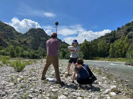
The survey should be conducted during one or two lab periods (if during the regular semester). First, the instructor and/or student must acquire and check equipment for the survey (e.g., UAV, RTK GPS/GNSS units, GCP targets, batteries, first-aid kit, water, food, etc.). At the field site, the students and instructor should assess the pre-survey plan, revise as needed, and decide on a staging area and bring equipment there. Students should divide into groups to disperse the GCP targets according to the survey plan and measure their precise location with the RTK GPS/GNSS units while taking notes. The UAV survey occurs in tandem with or following measurement of the GCPs. After the survey, students should collect and inventory all field equipment before packing the vehicles and departing the field area. Instructors can request support for GPS/GNSS instrument loans from EarthScope Consortium, which runs the NSF's geodetic facility.
Processing the data
In a computer lab, this portion of the unit should take place during one or two lab periods. Computers must have Agisoft Metashape, a licensed software, if using the guide provided with these materials. Before class, the instructor should compile the photos from the UAV survey and the RTK GPS/GNSS data and provide this data to the students. The instructor should give a brief <5 min description of the goals and expected outcomes of the activity. The students can then work individually or in groups to work through the workflow provided. The instructor should circulate around the room to help students troubleshoot as needed.
1) Pre-survey Planning
The instructor presents students with a field area and asks them how they would best design an SfM survey with ground control points (GCPs), where the GCPs are surveyed with kinematic GNSS. What are the important considerations? Where would they place the base station and why? What are the best positions and materials for the GCP targets*, given survey needs, logistics, and safety? Students should first work individually, then in small groups to discuss the survey designs, before convening as a class to discuss and arrive at a consensus on the survey design plans.
*GCPs are typically identified with targets – physical markers that can be identified in the SfM photos – that are surveyed precisely with high-precision GPS/GNSS. Targets can be as simple as a clearly identifiable ground feature, like a lone boulder in a grassy field, but are more commonly temporary features, like flags, flat-lying fabric markers, or spray-painted X's.
2) Conducting the Survey
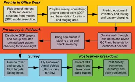 SfM with GCP survey workflow
Students will work in groups to implement the survey design for an SfM digital survey model with GCPs. Students are responsible for all aspects, from testing, packing, and setting up equipment to surveying and data collection (except for the UAV flight, which will be conducted by the instructor or technician with an appropriate FAA UAV license). It is best for students to divide tasks into groups and work as a team to efficiently conduct the survey (e.g., placing GCP targets, setting up and testing the base station and rover, and assessing the SfM flight path for on-site conditions). Students must collect well-organized and complete field notes, including appropriate field sketches, metadata, and logs, which will be submitted and assessed.
3) Data Processing and Assessment
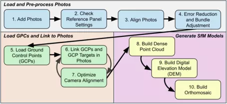 SfM-GCP data processing workflow
After students have implemented and completed their survey, they should hand in their field notebooks for assessment and feedback. The students will process the kinematic GPS data and the SfM data with GCPs using the guide provided, which walks students through the SfM with GCP processing using Agisoft Metashape. Students should prepare a written description and analysis of the lessons learned that summarizes their experience and knowledge of kinematic GNSS and SfM survey design and implementation with GCPs based on the Summative Student Exercise. It is recommended that students work individually to analyze and interpret their data based on the specific objective of the survey. This portion of the activity is class- and topic-specific, so the instructor is advised to adapt the activity as appropriate.
Teaching Materials
- Pre-survey planning - These planning documents can be used to practice the process at the example field site before doing pre-planing for the actual field site. Or the instructor could choose to adapt the files to feature the actual course field site from the beginning.
- Introduction to SfM with UAV GNSS and GCP surveying presentation (PowerPoint 2007 (.pptx) 13.4MB Sep5 25)
- Pre-class reading on SfM-GNSS surveying with GCPs (Microsoft Word 2007 (.docx) 5.8MB Aug9 25)
- Student exercise: SfM-GNSS pre-trip planning activity (Microsoft Word 2007 (.docx) 4.3MB Aug9 25)
- Example Survey Area.kmz (KMZ File 1kB Sep5 25)
- Conducting the survey, Data processing, and Assessment
- SfM survey using GNSS-GCP-UAV summative student exercise (Microsoft Word 2007 (.docx) 240kB Aug10 25) - This file provides a framework of a student exercise for a UAV SfM survey where the ground control points are georeferenced with GNSS. Instructors using this unit should plan to fill in details about their particular field setting and science question/s.
- MetaShape Guide for SfM with GNSS-georeferenced GCPs (UAV survey) (Microsoft Word 2007 (.docx) 33.4MB Sep5 25)
- Unit 1.1 rubric (Microsoft Word 2007 (.docx) 234kB Aug10 25) - This rubric has suggested grading criteria for the student planning, field, and summative exercises of the unit.
Teaching Notes and Tips
- Handling group sizes: With smaller groups, students will be introduced to the equipment and gain hands-on experience with each aspect of the survey. With larger groups, it is best to break them into smaller groups and introduce the equipment by rotating instructors. Furthermore, for larger classes, groups can be tasked with different components of the survey (e.g., placing GCP targets, setting up the RTK GNSS, testing the UAV, RTK GNSS survey of GCP targets, setting up and conducting the UAV survey) to ensure each group is actively involved in some aspect of the survey. In such cases, it is recommended that students from each group give presentations at the end of the day or the following class periods, explaining to the other students what their group has done. Equipment introduction can be done in the classroom or in the field. Aspects of survey pre-planning are best done in the classroom with the aid of Google Earth, but should be revisited and likely modified upon arrival at the field site depending on site conditions (e.g., obstructions, weather).
- Processing time: SfM post-collection processing takes several hours to days to complete. SfM post-processing is best done in a computer lab during another class or lab period. Students can work independently, in pairs, or in groups to generate 3D models. For larger groups, we recommend that students work in pairs, as computer skills are likely to vary. Prior to class, instructors should work to ensure quality control of the data collected and ensure that all data is easily accessible to all students before the start of the class or lab period, particularly for larger classes where various groups collect different data.
Assessment
Formative Assessment:
Much of the formative assessment can be done through observations of and discussions with students individually, in pairs, or periodically in the whole group. This could include:
- Introductory lecture: Class discussion, think-pair-share, and/or in-class planning activity
- In the field: probing questions, guided setup, and survey design
Summative Assessment:
A component of the summative assessment is the pre-trip planning activity exercise, in which students demonstrate their ability to design a plausible SfM/GNSS survey with GCP. A summative assessment for a general report that describes the survey workflow and the basic steps to generate an SfM model with GCPs is provided in the Summative Student Exercise. For a more thorough summative assessment, select a target science topic from the Analyzing High Resolution Topography Units 2-5 and adapt it to address a relevant field site for your course, or choose a prepared data set to have students work with.
- Unit 1.1 rubric (Microsoft Word 2007 (.docx) 234kB Aug10 25) - This rubric has suggested grading criteria for the student planning, field, and summative exercises of the unit.
References and Resources
- SfM UAV-GNSS change detection workflow 1-pager (Acrobat (PDF) 300kB Aug11 25) - 1-pager - Benjamin Crosby (Idaho State University)
- USGS Open-File Report 2021-1039: Processing Coastal Imagery With Agisoft Metashape Professional Edition, Version 1.6—Structure From Motion Workflow Documentation. Jin-Si R. Over, Andrew C. Ritchie, Christine J. Kranenburg, Jenna A. Brown, Daniel D. Buscombe, Tom Noble, Christopher R. Sherwood, Jonathan A. Warrick, and Phillipe A. Wernette. https://doi.org/10.3133/ofr20211039
- James, M.R., Chandler, J.H, Eltner, A., Fraser, C., Miller, P.E., Mills, J.P., Noble, T., Robson, S., Lane, S.N., (2019) Guidelines on the use of structure‐from‐motion photogrammetry in geomorphic research, Earth Surface Processes and Landforms, first published: 17 April 2019 https://doi.org/10.1002/esp.4637