Initial Publication Date: June 26, 2012
Other mapping projects in Google Earth
Barbara Tewksbury (Hamilton College)Inclined layers in
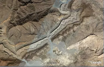
folded rocks near Karkh, Pakistan (27 50 35.00N, 67 10 03.70E). Click
image to enlarge.
Google
Earth has many fabulous and well-exposed areas that are suitable for
mapping in folded terrain. Some, such as the area shown at right in
Pakistan, also have strong color contrasts among units, making the areas
amenable for mapping contacts. Using the Google Earth 3D view makes it
possible for my students to visualize the relationships in areas where
students from previous years would have simply thrown up their hands in
frustration.
You'll find a great collection of potential sites for mapping projects in areas of folded and faults rocks here. Below, you can download two specific assignments that I have used in my structural geology class.
- A take-home exam (Microsoft Word 1.2MB Oct18 08): the 10 mapping areas referred
to in the download are denoted with single asterisks in the image collection referred to
above.
- A complex virtual mapping project (Microsoft Word 1.9MB Oct18 08): this project
combines Google Earth views with SRTM DEMs and ASTER imagery in ArcMAP
and provides an outstanding opportunity for a more extensive and complex
virtual mapping project that also incorporates rock samples and thin
sections (some with kinematic indicators). The area lies in the
Anti-Atlas Mountains of Morocco and is shown below. The assignment
itself is a bit bare bones, because I put it together at the last minute
for a student who couldn't go on a required field trip. It could be
spiffed up with an interesting scenario or by requiring the student to
make the map in ArcGIS rather than by hand. But it might stimulate some
good ideas for your own labs!
Go to the collection of mapping areas
Go to Visualizing inclined contacts - Visualizing strike & dip - Visualizing vertical contacts - Visualizing horizontal contacts - Visualizing folds - Other mapping projects


