Initial Publication Date: June 26, 2012
Locations in Google Earth for teaching geologic mapping and map interpretation
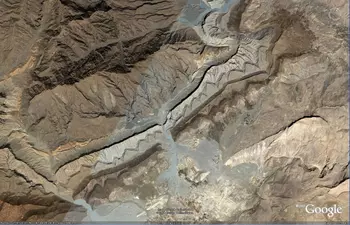
Google Earth is a terrific resource for teaching geologic map interpretation and geologic mapping. Google Earth satellite images in many places in the world show bedrock units with strong, contrasting colors in areas with little vegetation. Imagery is seamless and, in many places, high resolution. Below, you'll find images and location information for some fabulous areas around the world that are suitable for teaching students mapping and map interpretation. Elsewhere on this site, we have information on how to teach geologic map interpretation using Google Earth.
Comments or suggestions? Contact Barbara Tewksbury (Hamilton College).
To go to the following places in Google Earth, copy and paste either the lat/lon or the place name into the Google Earth Fly-to box.
Or, you can download a kmz file of placemarks (Zip Archive 5kB Aug26 10), which includes the locations below plus placemarks for other great locations for mapping.
If you do not have Google Earth, you can download it here.
In the list below single asterisks (*) denote the images used in the take-home exam described here. Double asterisks (**) denote the extended mapping project described on the same page.
Inclined layers on limb of plunging anticline, near Khvorgu, Iran (27 33 48.03N, 56 26 24.71E)
Monocline in the eastern Iran (32 24 50.95N, 56 47 00.19E)
Raplee Anticline, Monument Upwarp, near Mexican Hat, Utah (37 09 15.44N, 109 49 20.24W)
Doubly plunging anticline near Chahar Gas, Iran (31 54 22.30N, 56 38 59.91E)
En echelon folds adjacent to strike slip fault, near Gamboli, Pakistan (29 49 29.91N, 68 19 45.34E)*
Faulted folds near Dubinovka, Iran (31 35 13.65N, 56 48 24.80E). Note: the image is rotated so that north is toward the upper left corner.
Domes and basins in the Anti-Atlas Mountains near Tadakoust, Morocco (29 27 26.62N, 08 38 40.69W)**
Overturned anticline in the Tian Shan Mountains northeast of Kashi, China (39 57 55.47N, 76 52 50.14E)*
Plunging folds in Anti-Atlas Mountains near Tilemsoun, Morocco (28 13 37.61N, 10 51 21.00W). Note: the image is rotated so that north is toward the upper left .
Folds and faulted dome in Anti-Atlas Mountains near 'ain el Orak, Algeria (33 15 59.36N, 0 39 11.10E)
Folds south of In Salah, Algeria (25 33 45.67N, 01 45 36.33E)*
Syncline near Dubinovka, Iran (32 08 57.72N, 56 42 25.77E). Note: the image is rotated so that north is toward the left.
Basin near Jukan, Iran (25 56 45.59N, 59 56 08.50E)
Folds in Anti-Atlas Mountains near Challala Dahrania, Algeria (33 06 44.63N, 0 08 31.19E)*
Faulted layers in eastern Iran (32 11 31.34N, 56 53 26.61E)
Folds in Paktika Province, Afghanistan (32 09 24.04N, 68 48 03.05E)*. Note: the image is rotated so that north is toward the right.
Folds near Baluchani Kash, Pakistan (26 36 42.73N, 62 32 25.26E)
Folds in Coahuila, Mexico (26 06 34.72N, 100 51 17.24W)*
Folds in Big Horn Basin near Greybull, Wyoming (44 36 00.09N, 108 07 17.89W)*
Folds in the Cape Ranges near Vyversrus, South Africa (33 33 35.52S, 21 07 22.69E)*
Folds in the Macdonnell Ranges near Watarrka National Park, Australia (24 13 26.82S, 132 08 11.38E)*
Folds in the Amatusuk Hills, Alaska (69 06 26.48N, 161 51 42.16W)*
Folds in the Valley and Ridge Province near State College, Pennsylvania (40 58 36.38N, 77 12 56.43W)*
Faulted folds in the Great Kavir Desert 75 km NNW of Jandaq, Iran (34 38 34.13N, 54 01 30.48E)


