Using lidar to track Lake Michigan bluff retreat and inform local communities
Summary
The coasts of the Great Lakes are highly dynamic environments. Bluff erosion provides sediment for beaches, but it also poses a hazard to life and infrastructure. Assessing bluff retreat is key to preventing or mitigating financial and infrastructure losses. This activity provides students with a valuable opportunity to utilize remote sensing (lidar) to explore dynamic coastal erosion. Students will analyze lidar topographic data and lake water levels to investigate how the morphology of a portion of Lake Michigan coastline changes over a decade timescale. Students will examine the interplay between the hydrosphere and the Earth's surface in the Great Lakes Region, as well as the impact of bluff erosion on local communities.
Context
Audience
![[creative commons]](/images/creativecommons_16.png)
Skills and concepts that students must have mastered
Students should have basic geomorphology terminology for glaciated areas (e.g., drumlin, esker, etc.) and for slopes (i.e., crest, toe, face, face retreat, bluff, etc.). Ideally, students will have practiced sketching exercises, but if not, the instructor should spend some time introducing sketching (suggestions are in the background reading.)
How the activity is situated in the course
This activity is a laboratory exercise that follows a lecture on coastal geomorphology. The coastal geomorphology unit is one of the last ones in our course. Students have studied mass wasting in a previous unit. However, this is not a pre-requisite for this exercise.
Goals
Content/concepts goals for this activity
- Characterize a coastal bluff in Wisconsin by identifying key features on a topographic profile, a student-made sketch, and satellite imagery. (Evaluate: Questions 1, 2, 3, 5, 6a, 7a)
- Summarize factors that make a bluff stable and unstable (Questions 4, 13)
- Describe how geomorphologists use topographic data to investigate changes in the coastline (Questions 6, 8)
Higher order thinking skills goals for this activity
- Analyze changes to the bluff geomorphology over the decadal-timescale using multi-temporal lidar. (Part B, questions 6b-f, 7b-e, 15)
- Develop and test predictions about changes to the bluff geomorphology related to changes in the water level in Lake Michigan. (Part C, questions 9 a-d, 10, 11,12,
- Explain the relationship between bluff stability and coastal erosion in the Great Lakes Region (Question 13, 14) and the relevance to the local community (Question 6g, 16, 17).
Skills goals for this activity
N/A
Description and Teaching Materials
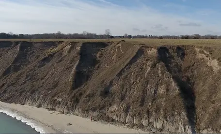
To engage students, we suggest showing the drone footage of the bluff along the coast of Wisconsin and asking students to interpret bluff processes using their prior knowledge. Focus on getting students to think about bluff erosion; the goal is to start the class with a discussion, rather than having the right answers. Instructors can follow up with thought-provoking questions such as: Do you think the bluff changes over a 10-year period? How much? What if you plan to buy land or develop a community center overlooking the lake? How would you get more information?* Instructors can show the bluff location on Google Earth using the different controls (3D, tilting, orientation) to review basic geomorphology terms and discuss the hazards created by bluff erosion along the Great Lakes coastline. *We provide links for government and regulatory agencies, and scientific/ research sources provide reports, maps, and zoning guides. Potential resources for further learning are compiled in the references and resources section.
- Background reading for lidar in Lake Michigan lab (Microsoft Word 2007 (.docx) bytes Sep25 25)
- Student handout for lidar in Lake Michigan lab (Microsoft Word 2007 (.docx) bytes Sep25 25)
- Slides show for instructor lidar in Lake Michigan Lab (PowerPoint 2007 (.pptx) bytes Sep25 25)
- Optional 3d printing file for instructors ( bytes Sep25 25)
Teaching Notes and Tips
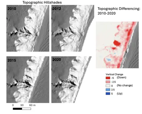
In Question 3, emphasize that students should draw a field sketch of the Wisconsin coastline. We noticed a few students had copied the field sketch from the provided example in Banff. Students also need to label features and provide some sense of scale (use the scale-bar from the image, or label the height of trees in the image, etc) to receive full credit. In Question 6, we also opened Google Earth together as a class. Students who were more comfortable using Google Earth could answer these questions independently and explore Google Earth on their own. If your students need help navigating on Google Earth, we found that projecting the location on a screen proved useful. Additionally, the concept of topographic differencing can be confusing for students. We recommend instructors review this concept with students and explain how to read Figure 6 in detail as a class.
Assessment
Assessment for this activity is summative.
We provide the following suggestions for grading criteria:
- Answers with clear right/wrong might be 1 or 2 points for correctness.
- Open-ended questions might be 2 or 4 points, with answers that are "correct with appropriate explanation" getting full points and "partially correct and/or only partially explained" getting fewer points.
- We provide a rubric for how to grade the sketch in the answer key.
References and Resources
Materials for this lab
- Background reading
- Student worksheet
- Coastal bluff seen with lidar: https://youtu.be/qsX6385uAiQ?si=0ol_NZt61f2QwVjf
- 3D printing file for instructors who want to have a 3D print of the study area
Teaching Materials provided
- Editable PowerPoint Presentation for instructors
- The answer file is available for educators in Teaching Stach or by emailing Carolina Michel at michelca@msu.edu or Chelsea Scott at cpscott1@asu.edu
Web sources
- Drone clip by Collin Roland and Luke Zoet (University of Wisconsin-Madison). Students use the drone clip to observe the terrain https://youtu.be/b32nK4y-tEw.
- Time-lapse video by Collin Roland and Luke Zoet (University of Wisconsin-Madison). Students use the video to describe bluff erosion. https://youtu.be/tNTn9NLn2EY
- Lake Michigan Bluff Retreat Seen with Lidar: Students use this video to see how to use Google Earth and hillshades from lidar to observe the change in coastal bluffs in Port Washington. https://youtu.be/7TnTuN8opE4?si=6qIWe6tOraZRImaG.
- Lake Michigan Shoreline Differencing on OpenTopography: For instructors or students wanting to learn how they can generate topographic differencing and visualize it using free platforms, such as Open Topography and QGIS. https://youtu.be/qsX6385uAiQ?si=lLIdnPDahb-ORTrc
OpenTopography is supported by theNational Science Foundation under Award Numbers2410799, 2410800 & 2410801