Initial Publication Date: August 11, 2023 | Revision: September 23, 2026
- First Publication: August 11, 2023
- Revision: September 23, 2026 -- Revision based on reviews
- Revision: September 23, 2026 -- Revision based on reviews
|
Cite thisVectors: Practice Problems
Solving Earth Science Problems with Direction and Magnitude
Examining relative sea level change in North America
Sea level is not changing at the same rate everywhere. Relative sea level change is the sum of sea level rising due to climate change and land moving up or down, in part due to the isostatic adjustment of the continent after ice sheet melting since the last glacial maximum. We can investigate the balance between these phenomena using a vector map of the rates of relative sea level change along the coastlines of North America.

Fig. 1. NOAA Sea Level Map
![[reuse info]](/images/information_16.png)
Provenance: https://tidesandcurrents.noaa.gov/sltrends/
Reuse: This item is in the public domain and maybe reused freely without restriction.
Problem 1: Use the map in Figure 1 to identify and interpret patterns in the rates of relative sea level change along the North American coastlines.
Problem 1a. Look at the scale for magnitude of the vectors. What is the magnitude of the greatest rate of relative sea level rise vector on this map? What is the magnitude of the greatest rate of relative sea level fall vector represented in the map?
There is a vector along the Gulf Coast, near the Mississippi River delta, where the rate of relative sea level rise is greater than 9 millimeters per year (mm/yr). There are several vectors on the southern coast of Alaska and the western edge of Hudson Bay where the rate of relative sea level fall is more than 9 mm/yr.
Problem 1b. This map shows both shaded topography and sea level change rates. Are each of the properties a scalar value or a vector?
Vector-or-scalar Step 1. Determine if the value has a direction and a value or only a numeric value.
Topography is the representation of elevation, which has only a numerical value.
Sea level change has a numerical value (a magnitude) and a direction (up or down).
Vector-or-scalar Step 2. If the data has a numeric value only, it is a scalar value. If it has a magnitude and direction it is a vector.
Topography is the representation of elevation, which has only a numerical value, but not a direction, so it is a scalar.
Sea level change has a numerical value (a magnitude) and a direction (up or down), so it is a vector.
Problem 1c. Observe the trends present on the map. Are there regions that have overall high relative sea level rise vectors? What about relative sea level fall?
The east coast and the Gulf coast appear to have the highest rates of relative sea level rise; the rise is slower along the west coast. The relative sea level is falling along the southern coast of Alaska.
Movement of tectonic plates
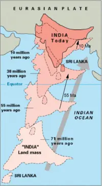
Fig. 2. India plate motions with vectors at 55 and 10 Ma
Provenance: USGS
Reuse: This item is in the public domain and maybe reused freely without restriction.
Vector math is important to the study of the movement of tectonic plates, because the vectors are the way scientists describe both the magnitude and direction of plate motion.
Problem 2. 55 million years ago, India was moving northeastward toward Asia at a rate of 150 mm/yr (fast!). But as India neared Asia, the rate slowed down, so that by 10 million years ago it was only moving one fourth as fast as it had been. The motion at 55 million years ago can be described by a vector ` bb"V"_(bb"55mya")` with magnitude 150 mm/yr and azimuth 14o. What are the magnitude and direction of the velocity vector ` bb"V"_(bb"10mya")` for motion 10 million years ago?
Multiply-by-scalar Step 1. Identify the magnitude and direction of the vector to be multiplied and the scalar multiplication factor.
The original vector magnitude = 150 mm/yr with an azimuth (direction) of 14o. The scalar multiplication factor is one fourth = 0.25
Multiply-by-scalar Step 2. Multiply the vector magnitude by the scalar to get the new magnitude and direction.
The magnitude of ` bb"V"_(bb"10mya") =150 ((mm)/(yr)) xx 0.25 = 37.5 ((mm)/(yr))` , which should be rounded to 38 mm/yr. Since the scalar is positive, the direction stays the same, azimuth 14o.
Multiply-by-scalar Step 3. Does your answer make sense?
The rate of 38 mm/yr is indeed much slower than the original 150 mm/yr and the direction should not have changed.
Motion of sand grains entrained by longshore transport

Fig. 3. Waves striking a beach at an angle cause swash and backwash, resulting in longshore drift
![[creative commons]](/images/creativecommons_16.png)
Provenance: https://www.internetgeography.net/topics/what-is-longshore-drift/
Reuse: This item is offered under a Creative Commons Attribution-NonCommercial-ShareAlike license http://creativecommons.org/licenses/by-nc-sa/3.0/ You may reuse this item for non-commercial purposes as long as you provide attribution and offer any derivative works under a similar license.
The transport of sand at the beach is controlled by wind-driven waves running up the beach face (the swash) and the water flowing back down the beach under the influence of gravity (the backwash). If the waves approach the shore perfectly perpendicular to the beach, the motion is one-dimensional. However, most waves approach the shore at an angle, causing motion parallel to the beach face as well (Fig. 3). We can examine the overall motion of the sand grains using the principles of vector math.
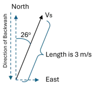
Problem 3: A wave strikes an east-west beach face with a swash velocity (`bb"V"_(bb"S")`) of 3 meters per second (m/s) and an azimuth of 26o. What is the velocity of the backwash (`bb"V"_(bb"BW")`) and the net eastward velocity (`bb"V"_(bb"S(E)")`) of a sand grain being transported by the wave? Assume that the grain has the same velocity as the water, there is only east-west net transport, and that the direction of backwash is perpendicular to the east-west beach face.
Components Step 1. Draw a diagram that shows the resultant vector magnitude and direction, and the direction of the components you want to solve for.
From the question text, the vector representing the velocity of the swash (
`bb"V"_(bb"S")`) has a magnitude of 3 meters per second (m/s) and an azimuth of 26
o. The question asks for the velocity of the backwash (
`bb"V"_(bb"BW")`), which is perpendicular to the beach and the net eastward velocity (
`bb"V"_(bb"S(E)")`), so we draw a diagram with the resultant and the 2 directions we are asked to find - east and the direction of backwash.
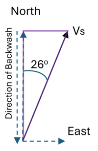
Components Step 2. Find the right triangle that includes the resultant, the components, and the angle.
The purple triangle on the vector component figure to the right includes the resultant, each of the components, and the angle. Note that the top side of the triangle is the same length as
`bb"V"_(bb"S(E)")`, so the length of the top side of the triangle is the magnitude
`bb"V"_(bb"S(E)")`.
Components Step 3. Use trigonometry to solve for the lengths of each component.
We can calculate the magnitude of the backwash and east component vectors of ` bb"V"_(bb"S")` (denoted as ` bb"V"_(bb"BW")` and ` bb"V"_(bb"S(E)")` respectively) using trigonometry.
` bb"V"_(bb"BW") = bb"V"_bb"S"*cos(alpha) = 3` m/s` * cos(26`o`) = 2.70` m/s
` bb"V"_(bb"S"(bb"E")) = bb"V"_bb"S"*sin(alpha) = 3` m/s` * sin(26`o`) = 1.32` m/s
The vector representing the eastward movement `bb"V"_(bb"S(E)")` has a magnitude of 1.32 m/s and an azimuth of 90o (which is to the east).
The vector representing the velocity of the backwash ` bb"V"_(bb"BW")` has a magnitude of 2.70 m/s, and an azimuth of 180o (which is to the south).
Components Step 4. Does your answer make sense?
Our magnitudes for ` bb"V"_(bb"BW")` and ` bb"V"_(bb"S(E)")` should be less than ` bb"V"_(bb"S")` , and this is true for our results. In addition, the net velocity should be parallel to the beach face (it is), and the backwash should be perpendicular (it is), so our answer is consistent.
Movement of a GPS station relative to another feature

Fig. 4. Blue vector shows the motion of the GPS station called TABL in California. White line shows the San Andreas Fault.
Provenance: Sarah Kruse, University of South Florida
Reuse: This item is in the public domain and maybe reused freely without restriction.
Problem 4. The GPS station TABL lies just 3 km from the San Andreas Fault, but it is not moving parallel to the fault (Fig. 4). The TABL station vector has magnitude (rate) = 26 mm/yr and an azimuth of 316
o. The San Andreas Fault nearby has an azimuth of 295
o. What is the component of the velocity at the TABL site parallel to the San Andreas Fault? What is the component of the velocity at TABL perpendicular to the San Andreas Fault?
Components Step 1. Draw a diagram that shows the resultant vector magnitude and direction, and the direction of the components you want to solve for.

Fig. 5. Blue vector shows motion of the GPS station TABL. White line shows the San Andreas Fault.
Provenance: Sarah Kruse, University of South Florida
Reuse: This item is in the public domain and maybe reused freely without restriction.
Draw a diagram that has the resultant vector (
VT) that is scaled to the magnitude and in an appropriate direction. Then draw two lines that start at the vector tail and go in a direction perpendicular to the San Andreas fault and perpendicular to the San Andreas Fault. (These are in black in the diagram to the right.)
Vperp is perpendicular to the fault and
Vpar is parallel.
The resultant vector magnitude should be VT= 26 mm/yr. The resultant vector azimuth should be 316o. Since the azimuth of the San Andreas fault is given as 295o, there should be an angle `beta` between VT and Vpar that is 316o- 295o = 21o.
Note that in Figure 5, the image is rotated so the San Andreas Fault is horizontal. This is just to help visualize the triangle so that the desired components are horizontal and vertical.
Components Step 2. Find the right triangle that includes the resultant, the components, and the angle.
Fig. 5. Blue vector shows motion of the GPS station TABL. White line shows the San Andreas Fault.
Provenance: Sarah Kruse, University of South Florida
Reuse: This item is in the public domain and maybe reused freely without restriction.
The yellow triangle includes the resultant, components, and the angle beta.
Components Step 3. Use trigonometry to solve for the lengths of each component.
`sin(beta) = (opp)/(hyp) = bb"V"_(bb"perp")/bb"V"_bb"T"`.
Rearranging,
`bb"V"_(bb"perp") = sin(beta)*bb"V"_bb"T" = 0.36 * 26` mm/yr `= 9.4` mm/yr
.
`cos(beta) = (adj)/(hyp) = bb"V"_(bb"par")/bb"V"_bb"T"`.
Rearranging, `bb"V"_(bb"par")= cos(beta)*bb"V"_bb"T" = 0.93 * 26` mm/yr `= 24` mm/yr .
Components Step 4. Does your answer make sense?
Check 1: Should the parallel and perpendicular components of motion have faster or slower rates than the resultant ` bb"V"_(bb"T")` ? Component magnitudes will always be smaller than the resultant magnitude, as can be seen from the yellow triangle. 9.4 mm/yr perpendicular and 24 mm/yr northward are indeed slower than the resultant 26 mm/yr.
Check 2: Just looking at the direction of ` bb"V"_(bb"T")` , should the perpendicular component be greater (faster) than the parallel? No, the plate at the TABL site is moving more in a direction closer to parallel than perpendicular to the San Andreas Fault. The perpendicular component of motion is only 9.4 mm/yr, while the parallel (24 mm/yr) is almost as great as the resultant motion of 26 mm/yr.
When will a sinkhole collapse?
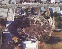
Fig. 5. Famous sinkhole collapse in Winter Park, FL in 1981.
Provenance: https://www.chicagotribune.com/nation-world/os-fla360-pictures-winter-park-sinkhole-20121113-photogallery.html
Reuse: This item is offered under a Creative Commons Attribution-NonCommercial-ShareAlike license http://creativecommons.org/licenses/by-nc-sa/3.0/ You may reuse this item for non-commercial purposes as long as you provide attribution and offer any derivative works under a similar license.
A sinkhole is a cavern in limestone. The roof will remain stable if the sum of the forces is upward, but if conditions change such that the sum of the forces becomes downward, the roof will collapse. The forces are shown in Figure 6.
Problem 5: Use vector addition to sum the forces on the roof of the cavern for the case when the weight of the roof produces a downward force of 6.1 x 10⁶ N, the cavern is filled with water that provides an upward buoyancy force of 1.2 x 10⁶ N. The cohesion on the sides of the roof is 5.2 x 10⁶ N, which is an upward force. Add the vectors so that you can determine if this sinkhole collapse?

Fig. 6. Sinkhole force balance.
Provenance: Sarah Kruse, University of South Florida
Reuse: This item is in the public domain and maybe reused freely without restriction.
Add Vectors Step 1. Identify the magnitude and direction of each vector given in the problem, and determine which vector needs to be solved for.
We need a coordinate system to define the direction of vectors. We'll define vertical up as positive, so vectors in the opposite direction (down) will be negative. With this coordinate system, the vectors to be summed are
- ` bb"F"_bb"w" "weight of roof" = -6.1 xx 10^6 N "(down = negative up)" `
- ` bb"F"_bb"b" "buoyancy force" = 1.2 xx 10^6 N "(up)" `
- ` bb"F"_bb"c" "cohesion" = 5.2 xx 10^6 N "(up)" `
Add Vectors Step 2. Break down each of the given vectors into their respective directional components.
The only direction is up-down, so we defined these in Step 1.
Add Vectors Step 3. Add the magnitudes of the components with the same direction.
We add the forces,
` bb"F"_(bb"sum")= bb"F"_bb"w" + bb"F"_bb"b" + bb"F"_bb"c" = -6.1 xx 10^6 N + 1.2 xx 10^6 N + 5.2 xx 10^6 N = 0.3 xx 10^6 N`
Since this is a positive number, this is a net upward force.
Add Vectors Step 4. Use your results in Step 3 to find the magnitude and azimuth of the sum vector.
We don't need to find the azimuth, because this problem just has one direction (up-down). The magnitude of the resultant vector is just the sum in Step 3, and the direction is up because the resultant is positive. This sinkhole will not collapse.
Add Vectors Step 5. Does your answer make sense?
The resultant sum in Step 3 is positive upward. Just checking, the sum of the two upward forces supporting the roof is `1.2 xx 10^6 N + 5.2 xx 10^6 N = 6.4 xx 10^6 N` (pink plus blue vectors in Figure 6). This is greater than the downward force of 6.1 x 10⁶ N (black vector in Figure 6), so greater upward force should keep the roof stable.
Ocean Buoy Movement
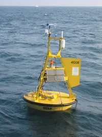
Problem 6. A buoy that measures ocean temperature is dropped in the North Pacific Current and moves 500 km at an azimuth of 75 degrees (East-North-East). Then, it gets caught in the California Current and moves 400 kilometers at an azimuth of 170 degrees (South-South-East). Find the net displacement of the buoy by adding the two vectors.
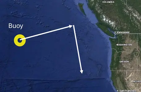
Provenance: Drawn by Eric Baer on a basemap from Google Maps.
Reuse: This item is offered under a Creative Commons Attribution-NonCommercial-ShareAlike license http://creativecommons.org/licenses/by-nc-sa/3.0/ You may reuse this item for non-commercial purposes as long as you provide attribution and offer any derivative works under a similar license.
Add Vectors Step 1. Identify the magnitude and direction of each vector given in the problem, and determine which vector needs to be solved for.
In this problem, the magnitudes and the directions of the two vectors are given explicitly in the problem. There are two vectors, one ( `bb"V"_(bb"NP")`) with a magnitude of 500 km and a direction of 75o and the other ( `bb"V"_(bb"CC")`) has a magnitude of 400 km and a direction of 170o.
We will determine the final vector as the sum of these two vectors `bb"V"_(bb"CC")`+ `bb"V"_(bb"NP")`
Add Vectors Step 2. Break down each of the given vectors into their respective directional components.
We will resolve these two vectors into North-South and East-West directional components. If you are comfortable with it, you could pick directional components that are parallel to one of the vectors, and it might be a bit less math, but for some students it is less intuitive, so we will go with North-South and East-West.
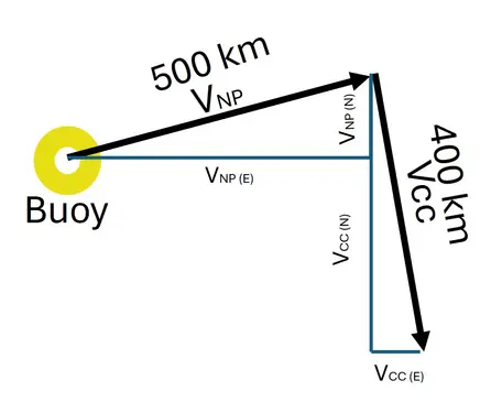
North Pacific Current:
Provenance: Eric Baer, Highline College
Reuse: This item is in the public domain and maybe reused freely without restriction.
`bb"V"_(bb"NP"(bb"N")) = cos(alpha) * bb"V"_(bb"NP") = cos(75`o`) * 500` km` = 0.259 * 500` km` = 129` km
`bb"V"_(bb"NP"(bb"E")) = sin(alpha) * bb"V"_(bb"NP") = sin(75`o`) * 500` km` = 0.966 * 500` km` = 483` km
California Current:
`bb"V"_(bb"CC"(bb"N"))= cos(alpha) * bb"V"_(bb"CC") = cos(170`o`) * 400` km` = -0.985 * 400` km` = -394` km
`bb"V"_(bb"CC"(bb"E"))= sin(alpha) * bb"V"_(bb"CC") = sin(170`o`) * 400` km` = 0.174 *400` km` = 69.5` km
Add the magnitudes of the components with the same direction.
Add the north components of both segments to get the north component of the resultant vector.
` bb"V"_(bb"total"(bb"N")) = bb"V"_(bb"NP"(bb"N")) + bb"V"_(bb"CC"(bb"N")) = 129` km` + -394` km` = -265` km
Add the east components of both segments to get the east component of the resultant vector.
` bb"V"_(bb"total"(bb"E")) = bb"V"_(bb"NP"(bb"E")) + bb"V"_(bb"CC"(bb"E")) = 483` km` + 69.5` km` = 553` km
Add Vectors Step 4. Use your results in Step 3 to find the magnitude and azimuth of the sum vector.
Recall that the component vectors are perpendicular to each other, so they form the opposite and adjacent sides of a right triangle. This means that the magnitude of the resultant vector can be found using the Pythagorean theorem:
`(bb"V"_(bb"total"))= sqrt[ (bb"V"_((bb"total"(bb"N"))))^bb"2" + (bb"V"_((bb"total"(bb"E"))))^bb"2"] = sqrt((-265 "km")^2 + (553 "km")^2) = 613` km
The azimuth can be determined by using the relation:
`alpha = tan^(-1) ((bb"V"_(bb"total"(bb"E")))/(bb"V"_(bb"total"(bb"N")))) = tan^(-1) (553` km` / -265` km`) = -64.4o
Since the displacement is southward, we add this angle (-64.4o) to 180 degrees to get the displacement relative to North.
`alpha` = -64.4o+180o=115.6o. This should be rounded to 116o.
Add Vectors Step 5. Does your answer make sense?
Check the magnitude: Your resultant vector should be longer than the original vectors and shorter than if you put the vectors in a line from head to tail. So the magnitude of the sum should be greater than 500km and 400km and less than 900 km. The magnitude is 613 km, so the magnitude of the answer makes sense.
Check the azimuth: The azimuth should be between the azimuths of the original vectors (75o and 170o). The calculated azimuth is 116o, so the result seems consistent.
Next Steps
TAKE THE QUIZ!!
I think I'm competent with vectors and I am ready to take the quiz! This link takes you to WAMAP. If your instructor has not given you instructions about WAMAP, you may not have to take the quiz.Or you can go back to the Vectors explanation page.
 Show me how
 Hide
Hide