
Instructor Virtual Workshop: Teaching in the field with SfM and RTK-GPS/GNSS to Undergraduates
August 11-15, 2025
Virtual
1st daily session: 6-8 am HI | 8-10 am AK | 9-11 am PT | 10 am-12 pm MT | 11 am-1 pm CT | 12-2 pm ET
2nd daily session: 11 am-12 pm HI | 12-1 pm AK | 2-3 pm PT | 3-4 pm MT | 4-5 pm CT | 5-6 pm ET (see Program for details)
Overview
Applications closed April 18, 2025. The workshop is full. Accepted attendees should be notified before the end of April.
Interested in getting hands-on experience with RTK-GPS and SfM methods, even if you cannot attend a workshop in person?
This workshop offers a great opportunity to learn field instrumentation methods you can integrate into a wide variety of undergraduate geoscience courses.
Workshop participants will learn practical approaches for creating georeferenced point clouds of high-resolution topography data using Structure from Motion (SfM) photogrammetry and Global Positioning System (GPS) -- which can be used to address geoscience research questions. Methods are appropriate for both summer field camps and academic-year courses with field components.
Participants will be sent a pair of GPS survey instruments to use during and the week after the workshop. Synchronous online sessions alternate with time to practice the methods somewhere outdoors, near where you are located. See Agenda.

- High Precision Positioning with Static and Kinematic GPS/GNSS
- Analyzing High Resolution Topography with TLS and SfM
Fieldwork is an integral part of the geosciences and there is a longstanding tradition of teaching field methods as part of the undergraduate curriculum. As Earth science research technologies have grown, there is more interest in introducing instrumentation into more geoscience courses. Technology integration into field education has several advantages, including student engagement and workforce development. This workshop has been developed in response to community interest and input and builds on successful pioneering efforts of EarthScope community members.
Attendees*
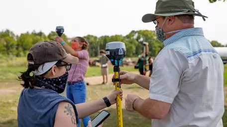 Geoscience students learning to do RTK GPS surveying.
![[reuse info]](/images/information_16.png)
This workshop is for US-based instructors interested in incorporating GPS and SfM field methods into undergraduate Earth and environmental science courses. We strongly recommend multiple participants from the same or near-by institutions. This will provide you with the opportunity for local collaborators on the field components AND allow the workshop to reach more people for the same number of instruments.
Community college and introductory-level instructors, as well as majors-level instructors, are all encouraged to apply. Later-stage graduate students with significant teaching responsibilities are also eligible, particularly if multiple people from the same (or near-by) institution participate.
*Participants must be at U.S. institutions for the instrument shipping. If you are interested in participating from outside the U.S. and have access to Emlid GPS receivers locally, please contact the email below.
Expectations
Participants in the workshop are expected to:
- Adhere to the EarthScope Code of Conduct
- Attend the entire virtual workshop (August 11-15, 2025)
- Return the instruments on time after the workshop (shipping labels will be supplied).
Goals
Participants will:
- Create a georeferenced SfM point cloud (this requires being able to successfully conduct both SfM and RTK-GNSS surveys)
- Be able to articulate how the methods can be used to address societally-relevant geoscience research questions
- Make implementation plans for teaching the methods in their own course/s
Micro-credential
- Proficiency certifies that participants have developed intermediate-level skills or competencies relevant to the course content. In this case, learning to design and conduct GNSS and SfM surveys, produce a georeferenced 3D point cloud, interpreted data to address real-world geoscience topics, and plan for teaching the topic to undergraduates.
- You can showcase the credential on platforms like LinkedIn, your CV, or personal website.
- After the workshop, if you use SfM and GNSS instruments in your undergraduate teaching and complete a short reflection form, you can earn the Mastery-level of the credential.
Leadership
Instructors
 Students taking pictures for SfM on an outcrop near Kathmandu.
![[creative commons]](/images/creativecommons_16.png)
- Benjamin Crosby (Idaho State University)
- Beth Pratt-Sitaula (EarthScope Consortium)
- DeeDee Okamoto (EarthScope Consortium)
Sponsors
- U.S. National Science Foundation-funded Geodetic Facility (GAGE) operated by EarthScope Consortium
- National Association of Geoscience Teachers (NAGT)
Questions
Contact Beth Pratt-Sitaula (beth.pratt-sitaula@earthscope.org)