
The Dynamic Earth
Summary
Context
Audience
Skills and concepts that students must have mastered
How the activity is situated in the course
Goals
Content/concepts goals for this activity
Higher order thinking skills goals for this activity
- Develop student map reading skills
- Develop 3-D visualization skills
- Develop student knowledge of Central American geography
Other skills goals for this activity
Description of the activity/assignment
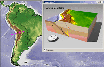
The Dynamic Earth module consists of five linked activity units that introduce students to the processes shaping Earth and the associated implications for society. Unit 1, Searching for Evidence, contains a visualization depicting topography across the Yucatan Peninsula of North America. This visualization begins as a 2D topographic map in which changes in color represent changes in elevation and topography. The map then rotates and tilts, while evolving into a 3D visualization with the same color coding. The 3D topography is then sequentially sliced revealing the topographic profile of the Yucatan Peninsula in an east-to-west cross section. The vertical exaggeration is increased, and the profile seamlessly evolves into an elevation vs. distance graph.
Students investigate the changes and variability in the earth's surface beginning with the examination of topography at different locations on the earth. This is accomplished through a region-by-region examination of topographic profiles. Spatial thinking skills required to relate topographic maps and topographic profiles can be difficult for students to develop when there are initial obstacles to conceptualizing in three dimensions. Students interact with visualizations from different tectonic settings that animate the transformation of a regional topographic map to the 3-D topography to the topographic profile plot.
This learning module was developed as part of The SAGUARO Project (formerly SAGE), directed by Michelle Hall-Wallace at the University of Arizona. SAGUARO utilizes Geographic Information System (GIS) software to conduct investigations of earth and environmental systems.
Determining whether students have met the goals
Teaching materials and tips
- The Dynamic Earth
In Unit 1: Searching for Evidence, follow link to the words 'large one.'
Other Materials
Supporting references/URLs
Michelle Hall-Wallace and Carla M. McAuliffe, 2002, Design, Implementation, and Evaluation of GIS-based Learning Materials in an Introductory Geoscience Course, Journal of Geoscience Education, vol. 50, no. 1, p. 5-14.
