Using StraboSpot for Field Sedimentology & Stratigraphy
Summary
Context
Audience
This module is designed to be flexible to allow students to experience a digital field notebook. The field notebook introduction of Part 1 would be appropriate for a wide variety of classes, however the sedimentological and stratigraphic tasks of Parts 2 and 3 are best suited for upper division sedimentology or field courses, guiding students through traditional workflows and reinforcing hierarchy of sedimentary terms.
Skills and concepts that students must have mastered
How the activity is situated in the course
Activity Length
Due to its flexible nature, the time required to implement the module varies from ~2 hours if using only the first activity outline to a full day if using all three activities. In addition, the module could be extended further if written reports and/or additional data sets are incorporated.Goals
Content/concepts goals for this activity
- Map location and interpretation
- Lithologic description
- Lithofacies differentiation and description
- Measuring/describing stratigraphic section
- Sedimentary succession interpretation
Higher order thinking skills goals for this activity
- Application of background sedimentological knowledge to make sedimentologic/stratigraphic observations.
- Analysis of data across varying scales to describe the lithofacies from grain- to outcrop-scale.
- Synthesis of observations to interpret the sedimentary succession.
- Creation of a measured stratigraphic section through incorporation of combined observations and interpretations.
Skills goals for this activity
- Gain familiarity with StraboSpot and the sedimentary vocabulary and workflow
- Produce a measured stratigraphic section
However, depending on how this flexible module is implemented, this can reinforce other skills (including short answer to full report writing, group team work, presentations, etc.).
Description and Teaching Materials
![[creative commons]](/images/creativecommons_16.png)
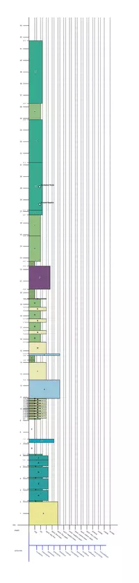
Supporting materials for this module include 1) the pdf outline of this activity, 2) the pdf 'Field Book' export of the data set (data input in chronologic order) from StraboSpot, 3) Annotated 3D outcrop model posters, 4) the Carmel Formation stratigraphic section export from StraboSpot, and 5) outcrop images from the Carmel Formation measured section. Materials can also be found at https://strabospot.org/teaching (note: Requires setting up a free account)
Module Outline: StraboSpot Module Outline (Acrobat (PDF) 329kB May19 20)
Justensen's Flats field book: Field Book (Acrobat (PDF) 13.2MB May19 20)
Justensen's Flats outcrop model posters: OutcropInterval1.pdf (Acrobat (PDF) 6.9MB May20 20), OutcropInterval2.pdf (Acrobat (PDF) 9.8MB May20 20), OutcropInterval3.pdf (Acrobat (PDF) 8.6MB May20 20), OutcropInterval4.pdf (Acrobat (PDF) 13.9MB May20 20)
Green River Channel outcrop model poster: CedarMountainModelScreenshot.pdf (Acrobat (PDF) 8.8MB May20 20)
Justensen's Flats measured section: JustensensFlats_Stratigraphic_Section.pdf (Acrobat (PDF) 389kB May20 20)
Justensen's Flats Outcrop Images: CarmelOutcropImages.pptx (PowerPoint 2007 (.pptx) 33.9MB May20 20)
Technology Needs
StraboSpot account (free)- While the mobile iOS and Android apps are usable without an account, data uploads and exports to/from StraboSpot require an account The StraboSpot app- Accessible through iOS or Android mobile devices (tablets are ideal due to increased screen size). Alternatively, the app can be accessed through a web browser on an internet-connected PC (http://www.strabospot.org).Assessment
References and Resources
https://strabospot.org/files/Strabo_Help_Guide.pdf - help guide for general use of StraboSpot
Comment? Start the discussion about Using StraboSpot for Field Sedimentology & Stratigraphy