
Mars Image Analysis
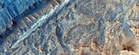 Sulfate and clay strata in Gale Crater from HiRISE, ESP_012841_1750. Image Credit: NASA/JPL/University of Arizona.
![[creative commons]](/images/creativecommons_16.png)
Homework 2_Remote Sensing
Julia Kahmann-Robinson PhD and Marjorie Chan PhD, University of Utah Department of Geology & Geophysics
Directions
View the following THEMIS image and answer the questions in reference to the image. As you view the image think about how this image might support one or more of NASA's main exploration goals:
- Determine if life ever existed on Mars
- Characterize the climate of Mars
- Characterize the geology of Mars
- Prepare for future human exploration of Mars
THEMIS Image: http://themis.asu.edu/node/5765
Note: For an in-class activity, post the image on a .ppt slide and/or as handouts to be discussed in class.
Questions
Getting to know THEMIS Imagery
- Before viewing the image, explain what THEMIS detects and how it works in a few sentences.
- What is the title of the THEMIS image?
- Study the THEMIS image. List at least (2) features you can observe.
- If the sun is illuminating from the left, are the features expressing positive (hill) or negative (valley) relief? If features differ from another (for example, one has positive relief and the other negative) please describe the features.
- What is the Lat/Long that the THEMIS image is centered on?
- Explain how this image meets NASA's exploration goals of Mars. If some goals are not met, please elaborate.
- If you were to lead a lander mission to an area located within the image, where would you land and why?
More THEMIS Imagery
Go to the THEMIS image gallery by Topic: http://themis.asu.edu/gallery choose an image you like and report the following:
- What is the Image ID or the Image url that you chose?
- Why did you choose this image?
- Where is the image located?
- What major Mars geographic region is it located near? (South/North pole, Victoria crater, Endurance crater, Merdiani Planum, Hellas Basin etc.) Use the View this image on Map link at the bottom of the image data column to see a map view of Mars.
- Why might this location be important to science?
HiRISE Imagery
Navigate to the HiRISE website: http://hirise.lpl.arizona.edu/
Scroll to the bottom of the page (gray box) and click on the link "Science Themes". Click on the Aeolian Processes file of images. Under the main image: click "View Images in this Theme". Find image titled: "Dunes in the Western Nereidum Montes". If you struggle, in the search box type in the image number: ESP_013046_1390 and search.
- Find the definition of the term Aeolian and explain here.
- Why might an image of aeolian processes on Mars be of interest to us on Earth?
- Sketch what you see below. Can you identify the direction of the wind if North on Mars is up? If so, what direction (cardinal directions) is it?