What is Geophysics?
Geophysics is a quantitative natural science that uses physics-based tools to study Earth processes and structures.
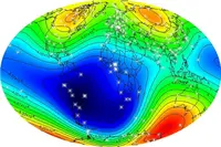
Total magnetic field for 2000 (NOAA).
![[reuse info]](/images/information_16.png)
Provenance: National Oceanic and Atmospheric Administration via Wikimedia Commons.
Reuse: This item is in the public domain and maybe reused freely without restriction.
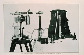
Mendenhall gravity measurement apparatus, 1895 (NOAA).
Provenance: National Oceanic and Atmospheric Administration, NOAA Central Library.
Reuse: This item is in the public domain and maybe reused freely without restriction.
Thinkers have explored geophysics concepts for thousands of years. Lodestone (with magnetite in it) was used for navigation dating back to antiquity and Zhang Heng is often credited with creating the first seismoscope in 132 A.D. Today, some geophysics tools are advanced enough for scientists to examine Earth processes with sub-millimeter precision and draw conclusions about structures deep within Earth.
The field of geophysics encompasses sub-disciplines such as geodesy (see What is Geodesy?), seismology, and near-surface geophysics. Geophysics tools are also used to answer questions in other disciplines as they often fill a shared need for making measurements of features that are difficult to reach -- archeology, planetary science, petroleum engineering, construction, and ecology frequently have uses for geophysics instruments, among many others.
Learn more from this video, What is Geophysics?
Seismology
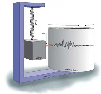
Illustration of a seismometer.
![[creative commons]](/images/creativecommons_16.png)
Provenance: Scott Johnson, EarthScope Consortium, Inc.
Reuse: This item is offered under a Creative Commons Attribution-NonCommercial-ShareAlike license http://creativecommons.org/licenses/by-nc-sa/3.0/ You may reuse this item for non-commercial purposes as long as you provide attribution and offer any derivative works under a similar license.
Seismology is the study of waves of energy released during earthquakes and other events (landslides, mine collapses, soccer games, explosions, etc.). It is typically used to understand the structure of the Earth and how, why, and where earthquakes occur.
During an earthquake, energy is released as multiple waves:
- P-waves, or longitudinal waves, which travel the fastest
- S-waves, or shear waves, which travel the second-fastest
- Surface waves, or Love and Rayleigh waves, which travel the slowest
Because these waves travel at different speeds, the lag-time between their arrivals increases at locations farther away from the earthquake's epicenter. When an earthquake is recorded by a seismometer, this lag-time relationship can be used to determine how far away an earthquake's epicenter is. If at least three seismometers record an earthquake, the location of the epicenter can be determined using a method known as trilateration.
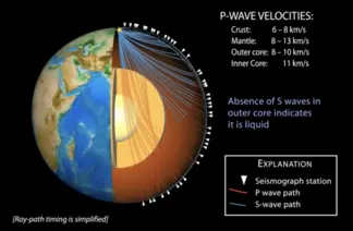
Seismic shadow zone.
Provenance: EarthScope Consortium, Inc., Jenda Johnson.
Reuse: This item is offered under a Creative Commons Attribution-NonCommercial-ShareAlike license http://creativecommons.org/licenses/by-nc-sa/3.0/ You may reuse this item for non-commercial purposes as long as you provide attribution and offer any derivative works under a similar license.
Earthquakes can also be used to study the structure of Earth's interior in an application known as
seismic tomography. For example, scientists deduced that Earth's outer core is liquid by mapping arrivals of P-waves and S-waves around the world. On the opposite side of Earth from an epicenter, there is a seismic shadow zone where P-waves appear, but S-waves do not. Because P-waves travel through liquids and S-waves do not, the best explanation is that the outer core is composed of liquid. A visualization of the shadow zone is presented in this video,
Layers of the Earth--What are they? How were they found?
Seismic tomography can also be used to identify variations in density throughout Earth materials. Seismic waves travel faster in materials that are denser, and scientists have studied the densities and corresponding speeds at which seismic waves travel through Earth materials. This allows assumptions to be made about geology from seismic data. Learn more from What is Seismology?
GETSI modules that feature seismic data and methods:
Near-surface geophysics methods
Near-surface geophysics methods allow for the collection of data with high spatial resolution in small (meters to kilometers), shallow survey areas. Multiple near-surface geophysics methods exist, each with its own advantages and disadvantages depending on the target. These tools provide incredible insight as to what exists in the subsurface, but sometimes there are multiple possibilities for structures that would produce the same results. This problem is referred to by geophysicists as nonuniqueness. If resources allow, it is often useful to collect data using multiple methods to reduce nonuniqueness and obtain a more thorough understanding of properties in the subsurface.
Learn more on What is Near-surface Geophysics? from this video and webpage.
Active-source seismic reflection and refraction

Seismic refraction survey.
Provenance: Beth Pratt-Sitaula, EarthScope Consortium
Reuse: This item is offered under a Creative Commons Attribution-NonCommercial-ShareAlike license http://creativecommons.org/licenses/by-nc-sa/3.0/ You may reuse this item for non-commercial purposes as long as you provide attribution and offer any derivative works under a similar license.
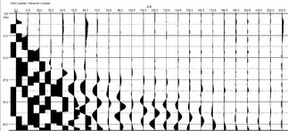
Seismic refraction data.
Provenance: The seismic refraction data was collected by Rick A. Hoover, PG of Quality Geosciences Company, LLC. We also recognize the York County Economic Alliance and their Codorus Creek Beautification Initiative.
Reuse: This item is offered under a Creative Commons Attribution-NonCommercial-ShareAlike license http://creativecommons.org/licenses/by-nc-sa/3.0/ You may reuse this item for non-commercial purposes as long as you provide attribution and offer any derivative works under a similar license.
Active-source seismic reflection and refraction leverage seismic tomography to obtain a detailed profile of wave speeds throughout a small, shallow survey area. The term "active-source" means that seismic waves are generated by surveyors rather than by tectonic processes. Depending on the depth of interest, different sources can be used; swinging a sledgehammer onto a metal plate is frequently used for shallow depths, and is very common. For deeper surveys, specialized trucks that drop weights ("thumpers") may be necessary. Explosives can also be carefully detonated, although this method is used much less frequently. As the seismic waves are produced, their arrivals are recorded at geophones spaced at even intervals along the survey line. Learn more about active source seismic surveys in these
seismic wave behavior animations and
How To: Seismic refraction field setup video.
GETSI module that features active seismic: Measuring Depth to Bedrock Using Seismic Refraction
Ground penetrating radar (GPR)
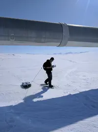
An operator pulls GPR across an ice field. Photo from USGS.
Provenance: U.S. Geological Survey, Water Resources Mission Area
Reuse: This item is in the public domain and maybe reused freely without restriction.
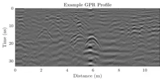
Example GPR profile with objects detected as hyperbolas.
Provenance: GETSI GPR Module, Unit 2 slide deck
Reuse: This item is offered under a Creative Commons Attribution-NonCommercial-ShareAlike license http://creativecommons.org/licenses/by-nc-sa/3.0/ You may reuse this item for non-commercial purposes as long as you provide attribution and offer any derivative works under a similar license.
Due to its ease of implementation, ground penetrating radar (GPR) is a near-surface geophysical method that is widely used beyond geophysical research. GPR emits microwave and radio-wave pulses that reflect off structures in the subsurface. The return times of these reflections are measured by a receiver. During data collection, the instrument is slowly moved over the study area on a lawn-mower-like cart, sled, or other vehicle depending on the terrain. Modern instruments often include screens that show data in real time. Subsurface structures appear as hyperbolas in a cross-section. Learn more about GPR in
GPR is not as simple as it's shown on TV and
How To: Ground Penetrating Radar field setup video.
GETSI module that features GPR: Forensic Geophysics Using Ground Penetrating Radar
Magnetism
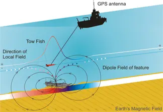
Magnetometers can also be towed by boats to detect magnetic anomalies under water. Figure by Karen Nichols and WA Graphics Team via Flickr.
Provenance: Illustration by Karen Nichols. This is from a set of graphics created by the WA Graphics Team for the Explore the Seafloor access and learning project. They were used in school packs, in display material and on the Explore the Seafloor website. For more information about this project please visit: ets.wessexarch.co.uk/ Accessed via flickr.
Reuse: This item is offered under a Creative Commons Attribution-NonCommercial-ShareAlike license http://creativecommons.org/licenses/by-nc-sa/3.0/ You may reuse this item for non-commercial purposes as long as you provide attribution and offer any derivative works under a similar license.
While a magnetic field can always be detected on Earth due to geomagnetism generated by the rotating outer core, metallic objects in the subsurface will generate an additional magnetic field in the presence of a functioning magnetometer or gradiometer. These instruments generate magnetic fields that induce electric currents in conductive materials, allowing them to be detected and mapped. In addition to locating metallic ore bodies, magnetism is particularly useful for locating archaeological objects and unmarked pipes or utilities before construction. Learn more in this
Environmental Magnetism video.
GETSI module that features magnetism: Locating Subsurface Features Using Gravity and Magnetics
Electrical resistivity
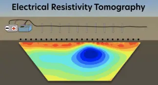
Illustration of an electrical resistivity tomogram.
Provenance: EarthScope Consortium, Inc.
Reuse: This item is offered under a Creative Commons Attribution-NonCommercial-ShareAlike license http://creativecommons.org/licenses/by-nc-sa/3.0/ You may reuse this item for non-commercial purposes as long as you provide attribution and offer any derivative works under a similar license.
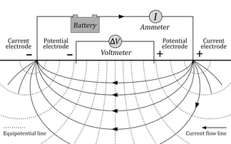
Illustration of an electrical resistivity survey setup.
Provenance: EarthScope Consortium, Inc. (GETSI Resistivity module, Unit 2 webpage).
Reuse: This item is offered under a Creative Commons Attribution-NonCommercial-ShareAlike license http://creativecommons.org/licenses/by-nc-sa/3.0/ You may reuse this item for non-commercial purposes as long as you provide attribution and offer any derivative works under a similar license.
Electrical resistivity is a property of a material indicating how much it resists the flow of electricity. For example, water has a low resistivity and atmospheric air has a high resistivity. Resistivity can be used to understand properties of Earth's subsurface such as saturation, salinity, groundwater contamination, and metal content. To conduct an electrical resistivity tomography (ERT) survey, metal stakes are hammered into the ground and connected by cables, forming electrodes. Cables are attached to a resistivity meter and power source, allowing current to be supplied to the electrodes. Learn more in
ERT: Imaging Sub-Surface Structures animation and
How To: Electrical Resistivity Setup video.
GETSI module that features ERT: Evaluating the Health of an Urban Wetland with Electrical Resistivity
Electromagnetism
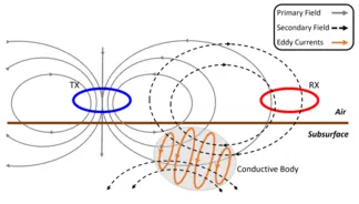
Electromagnetic induction produces eddy currents in conductive subsurface materials.
Provenance: Gavin Wilson, Jacob Conrad, John Anderson, Andrei Swidinsky, Jeffrey Shragge via Wikimedia Commons.
Reuse: This item is offered under a Creative Commons Attribution-NonCommercial-ShareAlike license http://creativecommons.org/licenses/by-nc-sa/3.0/ You may reuse this item for non-commercial purposes as long as you provide attribution and offer any derivative works under a similar license.
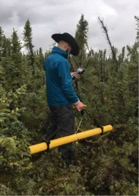
Electromagnetic surveying.
Provenance: Andy Parsekian
Reuse: This item is offered under a Creative Commons Attribution-NonCommercial-ShareAlike license http://creativecommons.org/licenses/by-nc-sa/3.0/ You may reuse this item for non-commercial purposes as long as you provide attribution and offer any derivative works under a similar license.
Electromagnetic surveying uses the principle of electromagnetic induction to detect the conductivity of the subsurface. The law of induction states that moving magnets can induce electrical currents in conductive materials, and changing electrical currents can induce magnetic fields. Electromagnetic surveying equipment employs this principle to induce electrical "eddy" currents in the subsurface. Eddy currents induce their own magnetic fields, the strength of which are dependent on the conductivity of the subsurface and are measured by a receiver. Conductivity and resistivity both tell us about the ability of the subsurface to conduct electricity, so you may wonder when one method is used instead of the other. Unlike resistivity surveying, electromagnetic surveying is completely non-invasive; nothing is hammered, or even placed on the ground. This often makes electromagnetic surveying the preferred method in areas that are ecologically fragile (e.g. permafrost, biological soil crust), have restrictions or dangers that prevent digging (e.g. protected archeological sites, unmapped utilities), or have inaccessible terrain (e.g. alpine environments). While most equipment is designed to be carried and features two wire loops attached to a portable battery and a plank or tube, electromagnetic surveying equipment can also be much larger and flown by aircraft or drone.
GETSI module that features electromagnetism: Electromagnetic Exploration of Thawing Permafrost
Gravity
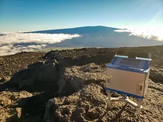
A gravity survey is conducted at Mauna Kea in Hawaii.
Provenance: U.S. Geological Survey, Mauna Loa.
Reuse: This item is in the public domain and maybe reused freely without restriction.
While gravity feels the same to humans everywhere on Earth's surface, there are actually small variations in the gravitational field. These variations occur due to changes in nearby mass and distance from Earth's center of mass. For example, gravity is weaker at the equator than at the poles because Earth's radius is larger at the equator than at the poles. Additionally, gravity might be stronger in a mountain range than in the foothills because there is more mass underfoot to attract another object. Large-scale variations in Earth's gravity have been observed by twin satellites in the
Gravity Recovery And Climate Experiment (GRACE) and Follow-On mission (GRACE-FO); these missions are discussed more on the
What is Geodesy? page. Small scale variations can also be detected with gravimeters in gravity surveys. The gravity method is extremely useful for locating objects or structures in the subsurface that have a much different density than the surrounding rock. Caves and karst voids, buried gas tanks, magma reservoirs, and ore bodies are excellent targets for gravity surveys. Learn more from the
What Is Gravity? How can we use it to find buried objects in the Earth? animation.
To learn more about gravity surveying, explore the GETSI module Locating Subsurface Features Using Gravity and Magnetics

An illustration of gravity anomalies along a profile.
Provenance: EarthScope Consortium, Inc.
Reuse: This item is offered under a Creative Commons Attribution-NonCommercial-ShareAlike license http://creativecommons.org/licenses/by-nc-sa/3.0/ You may reuse this item for non-commercial purposes as long as you provide attribution and offer any derivative works under a similar license.
Magnetotellurics
Magnetotellurics uses ambient electrical current from solar wind, thunderstorms, and other Earth processes to detect the electrical resistivity of the deep subsurface. The use of natural electric current makes this method a passive geophysics technique, unlike electrical resistivity surveys; the equipment detects a signal that already exists, rather than emitting a synthetic signal and detecting the signal's return. Magnetotellurics is also capable of imaging much deeper portions of Earth (up to hundreds of kilometers in depth) because it relies on lower frequency electromagnetic waves that propagate farther into Earth. Due to the long wave periods and low signal-to-noise ratios, magnetotellurics often requires instruments to be deployed for weeks or longer. The MTArray was completed in 2024, providing a spatially comprehensive magnetotellurics dataset of the contiguous United States. This data continues to provide insights into the plumbing of volcanic systems, faults and subduction zones, and electrical storms. Learn more from What is Magnetotellurics?
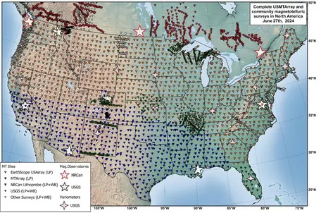
Locations comprising the MTArray (2006-2024). Figure by USGS.
Provenance: U.S. Geological Survey, Communications and Publishing
Reuse: This item is in the public domain and maybe reused freely without restriction.
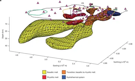
Model produced by Bennington et al., 2025 showing resistivity throughout Yellowstone's magma system, produced with the magnetotellurics method.
Provenance: Bennington et al., 2025, Nature Communications.
Reuse: This item is offered under a Creative Commons Attribution-NonCommercial-ShareAlike license http://creativecommons.org/licenses/by-nc-sa/3.0/ You may reuse this item for non-commercial purposes as long as you provide attribution and offer any derivative works under a similar license.
Distributed acoustic sensing (DAS)
Distributed acoustic sensing (DAS) is a near-surface geophysics method that leverages fiber optic cables. Often already in place around the world for communication purposes, fiber optic cables have tiny glass fibers inside them that can deform with ground motion. When light pulses emitted by an instrument called an "interrogator" pass through the cables, the imperfections in the cable create backscatter. The locations at which the cable deforms can be determined based on the return time of the light, and the amount of deformation can be estimated by the change in phase of the backscattered light wave. With processing, the causes of deformation can be analyzed.
Because cables can be hundreds of kilometers in length and continuous data is collected along the length of each cable, handling vast quantities of data tends to be the biggest obstacle when using DAS. In spite of this, DAS is extremely useful for a variety of applications including seismology, volcanology, and tsunami hazards. Learn more from What is Distributed Acoustic Sensing?
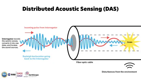
Disturbances from the environment (e.g. earthquakes, traffic) can cause strain in fiber optic cables, backscattering light waves to an interrogator.
Provenance: David Loria, EarthScope Consortium, Inc.
Reuse: This item is offered under a Creative Commons Attribution-NonCommercial-ShareAlike license http://creativecommons.org/licenses/by-nc-sa/3.0/ You may reuse this item for non-commercial purposes as long as you provide attribution and offer any derivative works under a similar license.
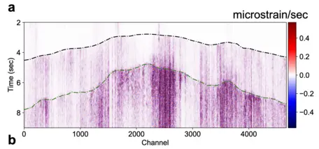
Figure from Li et al., 2023 showing arrival of P-wave (black dashed line) and S-wave (green dashed line) detected by DAS for a M2.5 earthquake.
Provenance: Li et al., 2023, Nature Communications.
Reuse: This item is offered under a Creative Commons Attribution-NonCommercial-ShareAlike license http://creativecommons.org/licenses/by-nc-sa/3.0/ You may reuse this item for non-commercial purposes as long as you provide attribution and offer any derivative works under a similar license.

