Density, Isostasy, and Topography
Anne Egger
, Stanford University
Author ProfileSummary
In this activity, students develop an explanation for the bimodal topography of the earth through measuring densities of rocks and wood blocks, deriving the isostasy equation, and applying their knowledge to estimate crustal thicknesses.
Context
Audience
This activity is used in an introductory physical geology course entitled "Dynamic Earth". The students in the course range from first-quarter freshmen to senior engineering majors.
Skills and concepts that students must have mastered
Students must be familiar with plate tectonics and earth structure, particularly the compositional and mechanical divisions of the interior of the Earth. They need not be familiar with rock names or types.
How the activity is situated in the course
I use this activity in the 2nd or 3rd week of my course. It is a stand-alone activity, but I refer back to it frequently throughout the remainder of the course.
Goals
Content/concepts goals for this activity
By the end of this activity, students will be able to:
- Illustrate the concept of isostasy and give an example of isostatic rebound
- Describe the difference between continental and oceanic crust
- Utilize the isostasy equation to predict crustal thickness in various regions
- Illustrate the concept of isostasy and give an example of isostatic rebound
- Describe the difference between continental and oceanic crust
- Utilize the isostasy equation to predict crustal thickness in various regions
Higher order thinking skills goals for this activity
By the end of this activity, students will be able to:
- Use analog materials to model Earth materials
- Evaluate the quality of a data set (e.g. remove spurious data, suggest sources of error)
- Use analog materials to model Earth materials
- Evaluate the quality of a data set (e.g. remove spurious data, suggest sources of error)
Other skills goals for this activity
By the end of this activity, students will be able to:
- Apply quantitative skills to geological problems
- Apply quantitative skills to geological problems
Description of the activity/assignment
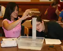
This activity begins with an exploration of a topographic map of the earth, ending with the question: Why is the distribution of topography on the earth bimodal? The students then collect two forms of data. They measure the density of the most common rocks that make up oceanic crust (basalt), continental crust (granite), and the mantle (peridotite). They also measure the density of several different kinds of wood, and how high each kind floats in a tub of water. In each case, they work in teams of two or three and then the entire class shares their data. Based on the data from the wood, they derive an equation that relates the density of the wood to the height at which the block floats in the water - the isostasy equation. They then substitute density values for real rocks into their equation to derive thicknesses for average continental and oceanic crust, and apply their knowledge in order to draw a cross-section of the crust across South America. This activity gives students a real, hands-on and mathematical understanding of the principle of isostasy.

Determining whether students have met the goals
After the classroom activity is completed in class, students read two articles: one from Scientific American and one from Geology (both listed below) and write a short summary that forces them to apply what they've learned in this activity. These papers are graded based on a rubric, also included below.
More information about assessment tools and techniques.Teaching materials and tips
- Activity Description/Assignment:Student handout for Density, Isostasy, and Topography activity (Microsoft Word 3.7MB Dec31 08)
- Instructors Notes:
- Solution Set:
Other Materials
- Follow-up writing assignment to Density, Isostasy, and Topography activity (Microsoft Word 29kB Dec31 08)
Supporting references/URLs
This activity was developed based on the "Isostasy" lab published in the Laboratory Manual in Physical Geology by the American Geological Institute (AGI) and the National Association of Geoscience Teachers (NAGT), Richard M. Busch, ed.
Students must have read the following short reading before they come to class:
Earth Structure, available at Visionlearning
Students are directed to the following reading after the completion of this activity:
Highs and Lows: Topography and Isostasy This website from the Global Change Program at University of Michigan provides a short summary of the topics discussed in class, and has an embedded interactive isostasy animation, where students can change the density of the block and see what happens.
For a follow-up writing assignment, students are asked to read these two articles:
Brandon and Pinter, 1997, "How Erosion Builds Mountains", Scientific American April 1997
Montgomery, D.R., et al, Climate, Tectonics, and the Morphology of the Andes: Geology, Jul 2001; 29: 579 - 582
This activity has supplemental information submitted as part of the InTeGrate Teaching the Methods of Geoscience workshop in June 2012.