For the Instructor
These student materials complement the Water Science and Society Instructor Materials. If you would like your students to have access to the student materials, we suggest you either point them at the Student Version which omits the framing pages with information designed for faculty (and this box). Or you can download these pages in several formats that you can include in your course website or local Learning Managment System. Learn more about using, modifying, and sharing InTeGrate teaching materials.The High Plains Aquifer
The High Plains Aquifer system consists of Tertiary sedimentary rock, dominantly sandstone and gravel (Figure 45), eroded from the ancient Rocky Mountains and deposited in the Tertiary period (from about 31 to 5 million years ago). The Ogallala Formation is the primary aquifer unit in the system. The aquifer underlies almost 175,000 mi2 and spans eight states, with most of its area in Nebraska, Texas, and Kansas. This region is among the largest and most productive croplands in the US, and is the source of almost 20% of our corn, wheat, and cotton production, as well as a significant portion of our soybeans, sorghum, and alfalfa. It is also host to almost 20% of the cattle raised in the US. Because the climate is semi-arid, with mean annual precipitation ranging from 12 inches in the West to 33 inches in the East, growing economically viable crops requires substantial irrigation. If you have ever flown over the Midwest on a clear day you may have seen circular "patches" of irrigated land - the hallmark of center-pivot irrigation systems (Figure 46).
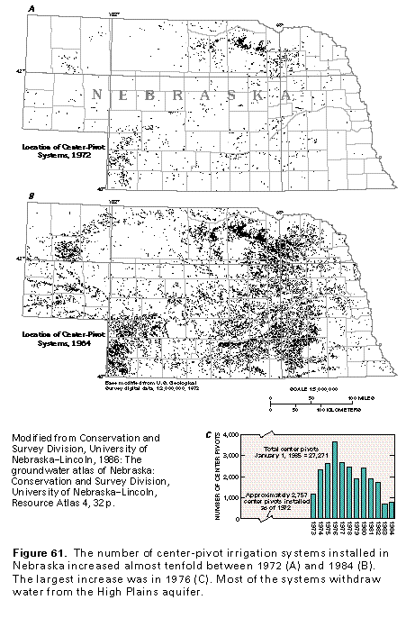
Although farming has been a major part of the economy in the region since the late 1800's, in the 1960's new technology in electrical pumps allowed access to deeper groundwater and ushered in an era of rapidly expanding irrigated acreage (Figure 47). Accompanying this expansion, aquifer-wide groundwater withdrawals increased from a few million acre-feet (M-AF) per year to almost 20 M-AF. Water level declines began in the 1950's, with the onset of intensive groundwater extraction for irrigation-based agriculture. The total overdraft of the aquifer is almost 250 million acre-feet, from pre-development (ca. 1950) to 2011 – this is almost 17 times the annual flow of the Colorado River.
 Figure 45. Outcrop of the Ogallala Formation in Texas.
Source: USGS High Plains Water Level Monitoring Study
 Figure 46. Satellite image of center pivot irrigation systems in Nebraska. Each circle is ~1/4 mile in diameter.
Image generated in Google Earth.
 Figure 47. Map showing single pivot irrigation systems in Nebraska in 1972 (upper map) and 1984 (lower map).
Source: USGS National Groundwater Atlas
 Figure 48. Map showing decreases in groundwater level from pre-development through 2011.
Source: USGS High Level Monitoring Study
As a consequence of sustained overdraft for several decades (see Figure 42 above), water levels in the aquifer have dropped substantially, by more than 100 feet in many areas (Figure 48). Over half of this decline has occurred since 2000. Water level declines are not evenly distributed, however. The highest rates of decline are focused in the southern reaches of the aquifer system, where recharge rates are low and irrigation demand is highest. In the northern portions of the aquifer system, water level declines are considerably smaller – and in some cases the water table has actually risen – primarily due to locally higher recharge focused along the Platte River (Figure 48).

