For the Instructor
These student materials complement the Water Science and Society Instructor Materials. If you would like your students to have access to the student materials, we suggest you either point them at the Student Version which omits the framing pages with information designed for faculty (and this box). Or you can download these pages in several formats that you can include in your course website or local Learning Managment System. Learn more about using, modifying, and sharing InTeGrate teaching materials.Rivers come in many shapes and sizes
If you take a tour through any given landscape, via car or virtually through Google Earth, you are very likely to see a variety of different river types. At first glance they may not appear so different (just a bunch of long tracks of flowing water), but if you look closer you will see that each river is, in a sense, unique, with some having a single channel while others may flow in multiple, interweaving channels. You'll see that each river has a different pattern of sinuosity (i.e., the frequency and amplitude of 'wiggles'), and each has their own variations of width and depth, differences in the material composing the channel bed and banks, and differences in the vegetation lining the channel. Figure 28 shows a few examples of different channel types.
The shape and size of a river depends on a multitude of factors that vary over time and space. A comprehensive discussion of these factors, and the interactions between them, is beyond the scope of this course, but it is useful to discuss how rivers are self-formed, dynamic systems. To a large extent, water 'designs' the channels through which it flows and, in the process, acts as the primary factor sculpting the features that comprise a landscape. Understanding how river channels form and change over time is a very active research topic in the fields of hydrology and geomorphology. Recent breakthroughs in numerical modeling (including computational fluid dynamics models that can resolve the complex structures of turbulence and fluid flow as well as morphodynamic models that can simulate interactions between flow, sediment and vegetation) and increasing availability of high resolution topography data (aerial light detection and ranging (lidar) data, terrestrial lidar, and high resolution surveying and 3-D photography techniques) have greatly enhanced our ability to study the form and dynamics of river channels in great detail, over vast areas. In the broadest sense, river channel form is controlled by a) the amount of water (especially the size of 'common' floods that occur once every few years, as discussed below), b) the underlying geology (the type of rock and variability within the rock structure), c) the amount and type of sediment supplied to the channel (coarse material such as sand and gravel as well as fine material such as silt and clay), and d) the type of riparian vegetation along the channel.
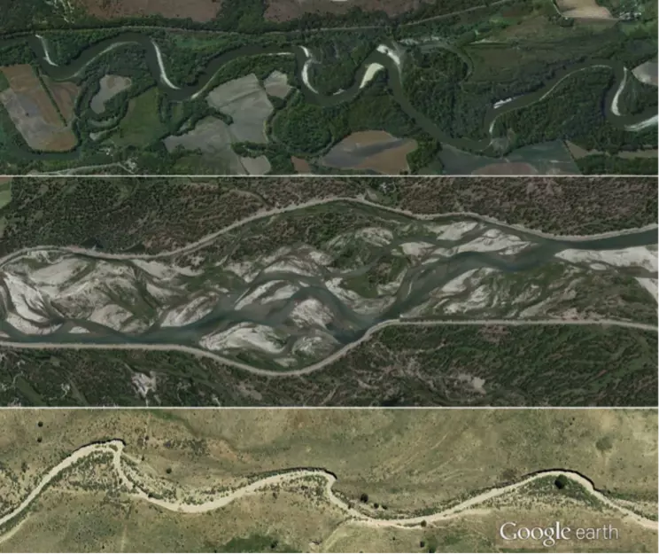 Figure 28. Examples of several different types of rivers. From top to bottom: Minnesota River near Mankato, MN (meandering, 100 m wide channel); Snake River in Grand Teton National Park, WY (braided , 1 km wide braid plain); ephemeral wash near Santa Fe, NM (ephemeral and meandering, 20 m wide channel).
Source: Images compiled by Patrick Belmont from Google Earth.
