
Unit 2: Application of Concepts to Case Studies
Summary
In Unit 2, students apply and evaluate foundational concepts about storm hazards and risk in the context of two cases studies: Superstorm Sandy (2012) and the Storm of the Century (1993). Through different activities and assignments, students develop skills for finding, evaluating, and relating data to case studies and build an understanding of preparedness, response, and resilience. The activities include: an analysis of hazard mitigation plans for their local community, examination of storm-related geophysical processes in the context of societal risks, preparation of a press release for community preparedness, and a peer review and revision opportunity for the press releases. Instructors may also end this unit by having students revise their concept maps from Unit 1, applying lessons learned in Units 1 and 2.
Learning Goals
After completing Unit 2, students will be able to:
- Find and analyze long-term sea-level and storm surge data;
- Evaluate the Hazard Mitigation Plan (HMP) for their local community in the context of major storms;
- Assess risk communication plans;
- Identify stakeholder positions for risk communication plans; and
- Develop their own risk communication plans and effectively communicate them in writing.
Context for Use
This Unit is designed to be implemented over two consecutive 90-minute class sessions, with homework after each session.
Students should complete Unit 1 of this module before Unit 2 begins. Unit 2 can be covered in ~ 3 course hours. Instructors should assign Unit 2 readings prior to starting Unit 2. Additionally, between class sessions, the following should be assigned as homework for Unit 2:
- HMP Review of Hurricane Sandy and the Storm of the Century
- Press Release Activity (complete before or during Class 4)
- Coastal Erosion Activity (optional)
- TEDxBarcelona talk "Sand Wars"
Unit 2 requires basic mathematics, locational geography, deductive reasoning, critical thinking, writing and editing skills appropriate for science and non-science majors at the university or advanced high-school level. It can be used in a lecture, lab, or online setting. Internet access, however, is essential for the research activities and to access data. Students also need a PDF-reader. Students should have successfully completed Unit 1 and demonstrated a solid understanding of risk assessment and risk management in order to reach the expected outcomes. For online courses, students should be able to make and upload drawings, such as their initial and revised concept maps.
Description and Teaching Materials
Jump to: Preparation for Unit 2| Unit 2, Day 1 | Homework Between Classes | Unit 2, Day 2 | Formative Assessment: Concept Map | Optional Activity: Coastal Erosion
Overview of Unit 2
While Unit 1 focuses on developing conceptual literacy, Unit 2 emphasizes relevant skill development. The activities encourage and promote data access, use, visualization, and analysis, as well as data-based writing. The lessons integrate the geophysical processes that create natural hazards with the social environment that creates risk. Through Unit 2, students learn how to employ the literacy in climate hazards, risks, and social response through emergency management and strategic planning to perform research tasks. In addition to building on their growing knowledge of the foundational concepts, students will find, evaluate, and relate geophysical data to case studies and their communities in the context of preparedness, response, and resilience. The unit helps students understand that for each storm, impacts and risk are part of a coupled natural and human system. Instructors may choose to end the Unit with students revisiting the concept map they created for Unit 1, by making changes that incorporate lessons learned in Units 1 and 2. The peer review process provides a low-stakes activity that reinforces systems thinking and the collaborative nature of risk assessment, management, and communication between experts and public officials. The opportunity to revise press releases at the end of Unit 2 reinforces the iterative nature of risk assessment, management, and communication. In addition, the process of identifying stakeholders and their roles helps prepare the students for the town-hall style debate at the end of the module.
Through a series of five assignments, students learn how to find, evaluate, and relate data to selected case studies: Hurricane Sandy and the 1993 Storm of the Century. Students apply these skills in a systems thinking approach to their own community and assess preparedness, response and resilience. Instructors may wish to supplement the provided materials with videos related to the case studies (information below in Teaching Notes and Tips).
As noted above, this unit is designed to be implemented after Unit 1, over two consecutive 90-minute class sessions. At the end of this unit, students should revise their Unit 1 concept maps, either in class or as homework, before starting Unit 3. Students should be encouraged to expand the map to include new system components and linkages in the system. The original and revised maps are a useful assessment for gauging how far the students have advanced their systems thinking skills within this module.
General Purpose:
This unit's purpose is to provide students with details about these two case studies (Superstorm Sandy and the Storm of the Century), so students can use the concepts and vocabulary introduced in Unit 1 to examine and understand real-world events. In addition, the unit introduces habits of mind regarding the interactions of short-term events like storms and long-term processes like sea-level rise. Students encounter real-world management decisions which were based on cost control and short-term risk mitigation, but which failed to consider how geologic services can also benefit societal needs.
The Sea-Level Rise Activity exposes students to map data and to model estimates of long-term and future sea level change. It reminds them about the relationships between hazard magnitude, frequency, recurrence interval and probability. Students use this information to answer questions related to storm surge and coastal flooding. Students examine the potential impact of these phenomena to critical infrastructure. For example, students compare current sea level and storm surge heights in recent storm disasters to predicted sea levels for 2050. They apply this new information to hazard assessment plans.
In the Press Release activity, students learn to critically assess their local hazard mitigation plans for a specific event---hurricanes and winter storms---and learn how risk is communicated to the general public at a time of crisis. The students use examples of weather-related press releases from government entities to develop new press releases that communicate risk related to a particular storm and storm stage. Students then evaluate the effectiveness of their communication in the Press Release Revision activity.
Specific Aims:
The initial activities and assignments in Unit 2 provide students with a common understanding of two major storms, and a deeper understanding of the complex impacts on, and interactions with, natural and human systems. The homework prepares students for class discussion and facilitates completion of Unit 2's activities and assignments. In addition to developing skills in utilizing and analyzing real science data, students work with complex geophysical systems and develop perspectives about long- and short-term geologic processes.
The Sea-Level Rise Activity encourages and promotes skills in data management, data visualization, data analysis, and writing for students in a real-world context. Student apply those skills and systems thinking to assess vulnerabilities, preparedness, response, and resilience. The activity requires that students consider storm hazards in terms of long-term processes of the Earth, like sea-level rise.
In the Peer Review activity, students have the opportunity to consider different elements of assessing and communicating risk for different storm types. They also develop awareness about risk communication---specifically the importance of clear, concise, and high-quality writing---and have the opportunity to receive feedback and incorporate that feedback in a revised draft.
Preparation for Unit 2
Students should successfully complete Unit 1 of the Major Storms Module before beginning Unit 2. Students must also complete readings on the two selected case studies before the first class in Unit 2.
Unit 2 Homework (to be completed before starting Part I)
Readings:
Superstorm Sandy:
- Risk Landscape: A Guide to Hazard Mitigation 'NYC's Risk Landscape: A Guide to Hazard Mitigation (Chapter 4, sections on Coastal Storms and Coastal Erosion)
- The Science Behind Superstorm Sandy's Crippling Storm Surge, an article from Scientific American;
- Superstorm Sandy Anniversary, an article from the Weather Channel.
1993 Storm of the Century:
- The Blizzard of '93: The Overview, an article from the New York Times;
- Blizzard of '93: Why Was It the Storm of the Century?, an article from AccuWeather;
- Superstorm: Eastern and Central U.S., March 1993, an article from Popular Mechanics.
Part I - Unit 2, Class 1: Sea Level
Instructors should present an overview of the data-related activities for the session (~ 15-20 minutes) to prepare students for in-class work. Allow time for questions and briefly review student outcomes from Unit 1. Students work in class on the Sea-Level Rise Activity (~ 1-1.5 hours); the activity can be completed as homework if students need extra time. Because students often need initial guidance in navigating the maps and software for this activity, we recommend beginning this activity in class. Reserve 10--15 minutes at the end of Class 1 to review student responses and answer questions.
Lesson Materials:
- ; Sea level Activity Instructor Notes and Rubric (Acrobat (PDF) 153kB Jul20 24)
- Sea level Activity (Microsoft Word 2007 (.docx) 30kB Oct10 24); Sea Level Activity pdf version (Acrobat (PDF) 130kB Oct10 24)
Unit 2 Homework (assigned between classes)
Homework Material(s):
- Instructor guidelines: ;
- Student handout: Press Release Assignment Student (Microsoft Word 2007 (.docx) 24kB Jul20 24); Press Release Assignment Student PDF Version (Acrobat (PDF) 116kB Jul20 24)
Part II – Unit 2, Class 2: Press Release and Peer Review Guidelines
Spend a few minutes discussing the results of the Sea Level Activity and homework assignments. Discuss mitigation efforts and recommendations for preparedness and resilience (~10 minutes). In this class session, instructors should form student pairs for the Peer Review Activity (students must have completed their Press Release Activity prior to the Peer Review). See Teaching Notes and Tips below regarding pair formation. Allow about ~20 minutes for students to complete the review and discuss feedback with their partner. Instructors should follow the Peer Review with ~10 minutes of class discussion, to review strengths and weaknesses of the press releases. Finally, if time remains, instructors should have students revise their concept maps from Unit 1 (time TBD by instructor).
Lesson Materials:
- Press Release Peer Review Guidelines (Microsoft Word 2007 (.docx) 17kB Jul20 24); Press Release Peer Review Guidelines PDF Version (Acrobat (PDF) 57kB Jul21 17)
- Press Release 1st Draft Rubric (Microsoft Word 2007 (.docx) 20kB Jul20 24)
- Press Release Revision Guidelines and the Press Release Rubric for the 2nd draft are found in Unit 3.
Unit 2 - Formative Activity: Revision of Major Storms, Storm Impacts, and Risk Concept Maps
This activity is intended to serve as a mid-module check point to assess student gains in systems awareness and understanding. It allows the students to revisit their initial perceptions about storms, storm impacts, and risks and either add onto their original concept maps or else start over with a new map that better represents their current breadth of knowledge. Before beginning this activity, instructors may find it helpful to review the activities of Units 1 and 2, and have students list some of the key concepts from those activities.
Materials: Students revise their concept maps developed during Unit 1 in this formative assessment activity (intended for the end of Unit 2). If they wish to start a new map, they should hand in both the new and old versions so the instructor can compare them.
General Purpose: To serve as a formative assessment for learning targets in Units 1 and 2.
Specific Aims: To reinforce ideas of systems thinking.
It is recommended that instructors implement this activity during Class 2, if there is time. If the peer review process fills the full class, instructors can assign the revision of the concept map for homework, to be collected before the start of Unit 3.
Optional Add-on Activity for Unit 2: Coastal Erosion
This activity uses Hurricane Sandy as a case study to examine the intersection between geologic processes and societal risks and costs associated with storms. It places these in the context of long-term processes like glaciations, sediment budgets, beach formation and erosion, plus societal factors like development, post-storm beach reconstructions and sand debris removal. This activity engages the students in complex natural and societal systems thinking using a common, everyday material: sand. A more detailed introduction and instructor information is in this file:
General Purpose: The purpose of the coastal erosion activity is to familiarize students with geoscience data as it relates to major storms and storm impacts, especially with regard to long-term geologic processes that provide beneficial societal services, such as the creation and maintenance of coastal dunes and barrier beaches. While highly recommended for students in geoscience, physical geography, and environmental science, the activity is designed and written so that non-science students can also understand and complete it.
Specific Aims: Through this activity, students use real geoscience data to develop perspectives unique to the geosciences, such as timescales of process. For example, the activity includes assessment of how short-duration events, like storms, affect longer-term natural processes like beach-building. Like the Sea-Level Rise Activity, the Coastal Erosion Activity helps students learn to apply those skills and a systems thinking approach to assess vulnerability, preparedness, response, and resilience of a community. The activity requires that students consider long-term natural processes, like sea-level rise, and how those processes may affect the impact of major storms. Students will also consider the role of stakeholders in the context of storm impacts. Thus, this activity will also work as a lead-in for the next homework assignments and Town Hall Meeting assignments of Unit 3.
Materials for Coastal Erosion Activity:
- ;
- ;
- ;
- NYC Hurricane Sandy After Action Report & Recommendations (May 2013)
Please note: Students should focus on the "Debris Removal" section of the report (pp.22-23), although the entire document may be useful as reference material in their preparation for the Town Hall in Unit 3. - USGS, Assess Community Vulnerability to Coastal Change Hazards for Hurricanes and Other Storm Scenarios
Recommendations for inclusion of optional activity: The Coastal Erosion Activity may be of particular interest to geoscience instructors who wish to more heavily emphasize the use of geoscience data and its application in their classrooms. It can build on the foundation established in the Sea-Level Rise Activity. Instructors in other disciplines (particularly non-science courses) may choose to opt out of the activity, depending on the skill level of the class. Assessment of the Sea-Level Activity should give instructors feedback on the appropriateness of employing the Coastal Erosion Activity. Instructors may want to consider the following in the context of the Sea-Level Rise Activity before including the Coastal Erosion Activity: 1) the length of time needed to complete the activity; 2) the level of student frustration and/or confidence in using data and map applications; 3) the level of student understanding in reviewing (potentially) unfamiliar geoscience processes.
Instructors who choose not to include the Coastal Erosion Activity should consider where in the module they can introduce the role of stakeholders in decision-making, in preparation for the Town Hall Meeting. Instructors can highlight the role of stakeholders that should be included in risk communications (Press Release Assignment), for example, or as part of their HMP Analysis in Unit 1.
Teaching Notes and Tips
Additional Background Info Sources (videos and informational sites)
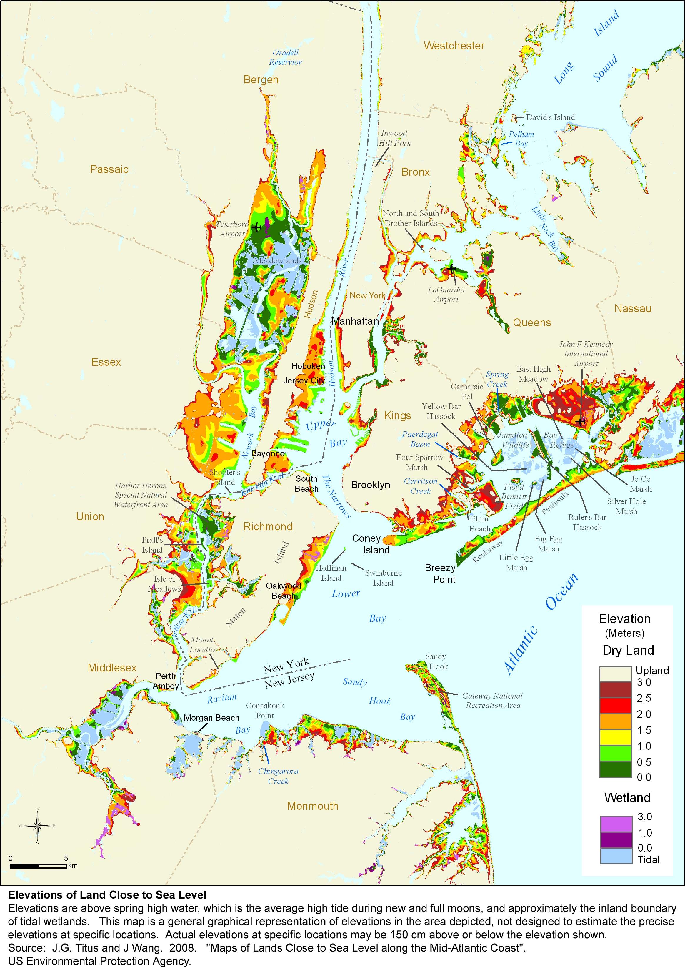
- To familiarize students with data available on storms, instructors may wish to demonstrate a couple of examples in class, using maps of sea level risk for NYC published in 2008 and maps of storm surge risk for the same areas from NYC.gov site's Plan for Hazards - Coastal Storms & Hurricanes - NYCEM.
- Instructors may wish to supplement the basic information included with videos of the two case studies. For Hurricane Sandy: National Geographic's Superstorm New York: What Really Happened (available from YouTube and other providers), PBS's Nova: Inside the Megastorm, or numerous short clips from news agencies. For the 1993 Super Storm (Storm of the Century), commentary is available online (20th Anniversary of the Blizzard of 1993). PBS Frontline has a follow-up story on problems with flood insurance coverage for Hurricane Sandy's called "Business of Disaster" that aired in May 2016.
- Activity materials include background information on particularly large storms using online data portals and reports such as NOAA's National Centers for Environmental Information (NCEI) Billion-Dollar Weather and Climate Disasters: Overview and their long-term impacts. Information on Superstorm Sandy and the 1993 Storm of the Century are in numerous NOAA Reports. In addition, students will have to find Hazard Mitigation Plans for their local community, as well as geoscience data (flood stages, snowfall, windspeed, etc.) on a recent major storm that hit their community.
- Additional information is available from such non-profit agencies as Coastal Care, with special reports on risk mediation efforts in NYC after Hurricane Sandy, and storm surge discussions by weather agencies like the National Hurricane Center and the Weather Underground.
Press Release Assignment
- For the Press Release Assignment, students should be responsible for finding their local community's own hazard mitigation plan. However, instructors must identify in advance what HMP is available (at a city- or state-level) and give students guidance on where to look to find the appropriate materials. For example, elements of an HMP are included on the City of Worcester's website, but a more detailed Hazard Mitigation Planning is only available for the state of Massachusetts. Instructors should decide which materials they want students to use and guide them to the appropriate information. Instructors in small communities may wish to assign the HMP for a large city or their state.
- While instructors may use the provided examples for the State of Massachusetts for the Press Release Assignment, we highly encourage using press release examples from each student's local community and, if winter storms and hurricanes are not a major threat to their area, to select storm types relevant to their local community.
- Students should be assigned one of two storm types (e.g., hurricanes or winter storms), in addition to a "phase" of the storm (e.g., pre-, during, or post-) as the focus of their press release. This is to illustrate that risk communication during different phases of a storm event will vary. For example, pre-storm communications may focus on preparedness, whereas post-storm are more likely to center on clean-up.
- Instructors should require that press releases be submitted in advance of the Unit 2, Day 2 class session (preferably by several hours, if not the day before). This will allow the instructor time to briefly review the assignment and determine if there are common mistakes or issues to be discussed during class.
Implementation of Peer Review
- Instructors may also review the earlier submissions to help determine how to pair students for the peer review. The authors recommend pairing students by contrasting storm types (e.g., a student who prepared a press release on winter storms with a student who prepared a press release on hurricanes) and with differing phases (e.g., a student who focused on pre-storm communication with a student who focused on communication during the event). Based on class size, this might not be possible for all pairs, but the priority should be on matching students with different storm types first.
- Students should receive feedback from their peers, as well as the instructor, with ample time before the next class meeting to allow them to incorporate feedback into their second drafts. Instructors may want to complete the rubrics before the Unit 2, Day 2 class session to return to students at the end of the session to help facilitate this. Another option would be to post completed rubrics online, or to email them to the students.
- Instructors should provide students with enough time during the peer review process to reflect on the feedback they have received. Students should be encouraged to use the back of their returned, completed rubric to note what revisions will be necessary and why.
- Instructors should follow the Peer Review with ~10 minutes of class discussion to review strengths and weaknesses of the press releases. During this time, instructors should highlight the importance of using data to support the points being communicated in the press release. Instructors should also use this time to discuss the role of stakeholders in risk communication and have students reflect on how stakeholders need to be addressed in their press releases.
Other
- Instructors should use the second rubric provided to evaluate the revised press release (see Revision Guidelines and Rubric for 2nd Draft in Unit 3). Instructors may choose to distribute the 2nd rubric - in class or electronically - so that students have additional guidance about the evaluation.
- The authors realize that instructors in some geographic regions (i.e., Southern California) may have difficulty selecting major storms relevant to their area. As such, we recommend using other major weather patterns (i.e., El Niño) or minor weather patterns (i.e., rain) coupled with other conditions that can cause hazards (i.e., mudslides).
Assessment
The Sea Level Activity can be assessed using the embedded questions to evaluate how well the students were able to follow directions, read and assess visual information, and understand the implications of millions of residents losing infrastructure (roads, public transportation, medical, fire and police services) and access to critical resources (clean water, electricity, food) for some days after the storm.
The three parts of the Press Release Assignment can be assessed using the Press Release 1st Draft Rubric (Microsoft Word 2007 (.docx) 20kB Jul20 24), which is filled out during peer review, and the Press Release Rubric - 2nd Draft (Microsoft Word 2007 (.docx) 21kB Jul20 24) or Press Release Rubric - 2nd Draft PDF Version (Acrobat (PDF) 84kB Nov4 16).
The optional pre- and post-unit concept maps provide an additional formative assessment of student progress in applying higher-order systems thinking major storms, storm impacts, and storm risks. Instructors might refer to this completed activity to address gaps in understanding and to point out over-looked aspects before Unit 3.
The coastal erosion activity can be assessed using the embedded questions to evaluate how well the students understand unit conversions and scaling factors, concepts of rate and resource replenishment, and visual profile data. Preferred responses are available in the
.Learning goals for Unit 2 are met when:
- Students correctly evaluate and relate geophysical data to their community in the context of preparedness, response, and resilience for a major storm;
- Students successfully translate data from their local HMP into a risk communication press release;
- Students demonstrate critical analysis of risk communications by evaluating a peer's press release;
- Students identify and accurately integrate knowledge about stakeholders' positions into their press releases; and
- Students demonstrate improvement in their writing skills by submitting a revised and improved second draft of their press release.
References and Resources
Additional Resources and References for Case Studies
Superstorm Sandy
- NPR's coverage of Sandy
- Flood, Rebuild, Repeat: Are We Ready for a Superstorm Sandy Every Other Year?
Storm of the Century
Press Release Assignment
- The was developed after consulting several examples. See Press Release Activity guidelines for a list.