
Unit 4: Comparing risks at different volcanoes
Summary
Students assess the risks from three different volcanoes based on the Risk Equation, Risk = Hazard x Value x Vulnerability. The three volcanoes--Fuego Guatemala, Rinjani Indonesia, and Moana Loa Hawaii--have varying characteristics, thus giving the opportunity for dynamic conversations and insights into different volcanoes and their affected communities. The final (jigsaw format) group product is a table that helps students to identify the volcano that poses the greatest risk and thus most needs monitoring. Students must present a clear rationale for why it is selected over other volcanoes, taking into consideration the volcanic hazards, population characteristics, and infrastructural vulnerabilities for each volcano. Students also complete a preparatory exercise on the characteristics of different Volcanic Explosivity Index (VEI) eruptions.
Learning Goals
Unit 4 Learning Outcomes
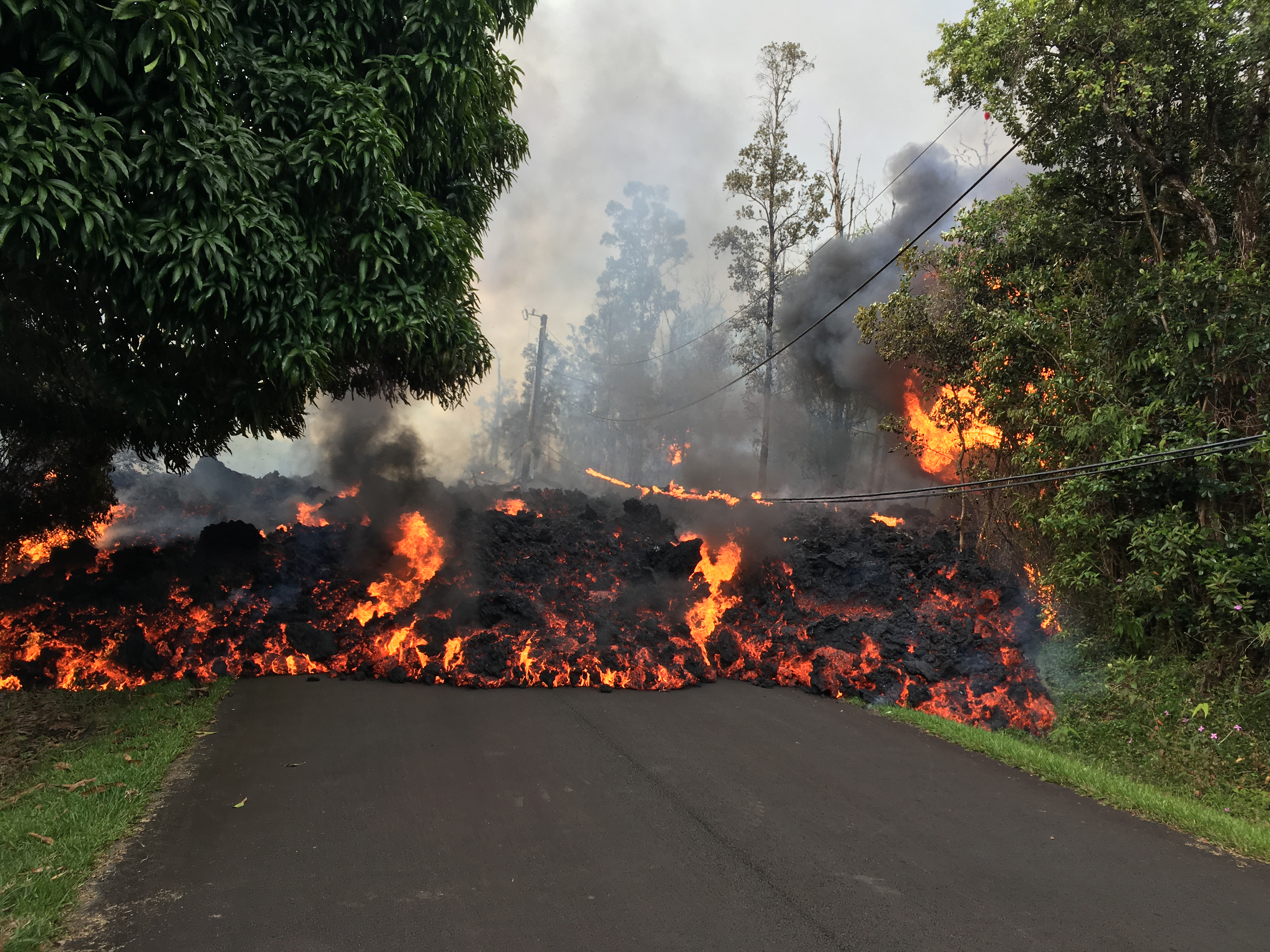
 Lava flow on Makamae Street, HI, from the 2019 Kilauea eruption. In this unit, students will analyze the volcanic hazards, population characteristics, and infrastructure vulnerabilities for a series of volcanoes. Image from USGS
 ![[creative commons]](/images/creativecommons_16.png)
Students will
- Assess the varying levels of risk for three different volcanoes with different styles of eruptions based on available geodetic data, human factors, mean recurrence intervals, and types of hazards.
- Compare volcano risks in order to recommend future volcano monitoring
- Communicate risk of volcanic eruption to a non-expert audience
Context for Use
This unit is designed for an introductory level non-majors geoscience course, but can be adapted to introductory-intermediate Volcanology, Geologic Hazards, and other courses. The unit can be completed in a 50 -75 minute class period if introductory materials are completed by students as pre-work (as noted in Teaching Materials). It will be helpful for students to be familiar with different volcano types, tectonic environments and magma sources, but pre-work and introductory information at the beginning of the activity review explosive and effusive eruptions and associated hazards. Students should also know that seismometers, GPS, InSAR and tiltmeters are used to monitor volcanoes and what data from those instruments indicate about magma movement. This is covered in Units 1, 2 and 3 (see module overview for details). In addition, students should have an understanding of what a mean recurrence interval is and what it means (which is also covered in Unit 3).
Description and Teaching Materials
Introductory/Pre-Class Work:
Before doing the main exercise, it is important that students understand the Volcanic Explosivity Index (VEI). To prepare for class, students should complete this reading and homework exercise in which they determine the types of eruptive materials and eruption impact time and distance for VEI 0-8.
- Student:
- Unit 4 Eruption Types Pre-Reading and Exercise (Microsoft Word 2007 (.docx) 6.2MB Feb3 23)
- (same table as in the exercise in case you want to send the students a separate digital version to fill in)
- Instructor:
In Class:
This work will include a review of different types of volcanoes and eruptions in the context of an overview of Mauna Loa, Fuego and Rinjani volcanoes, provided in the activity. Instructors can use the presentation to guide students through the class period.
- Unit 4 Instructor Presentation (PowerPoint 2007 (.pptx) 6.2MB Feb2 23)
The presentation contains embedded links to this video:
- Video: Role of USGS in Volcanic Crisis (MP4 Video 46.4MB Jan22 19)
- Video: Role of USGS in Volcanic Crisis - closed captions (MP4 Video 8.8MB Dec22 18)
Part 1 (All- class discussion, 10 min):
The presentation provides some starting slides that provide visuals for the three volcanoes that will be explored during this activity. Instructors can use the initial slides to focus the conversation around how these volcanoes vary from a VEI (Volcano Explosivity Index) and hazards standpoint based on the pre-reading. In addition, the video provides a context of what the role of the USGS has relative to emergency managers and other stakeholders. This will situate the activity upon which they are about to embark, in that they will make recommendations to an organization (VDAP) Volcano Disaster Assistance Program that works with local governments and agencies, but does not dictate what should be done.
Part 2 (Expert, small group work, 20 min):
The instructor assigns students one of three groups that explores one of the three volcanoes in depth: Mauna Loa, Fuego, or Rinjani. Students will work together to characterize the Volcanic Risk of their assigned volcano, using the provided handouts and questions (below). Characterizations include:
- Volcanic hazards: hazard maps and eruptive history
- Mean Recurrence Intervals (MRI): frequency and size of previous eruptions
- Current geodetic (and other volcanic) monitoring available: GPS, Tilt, InSAR, Lidar, Seismic
- Human impacts: population density
- Vulnerability to hazards: possible human structures to be impacted (homes, roads, dams), and corruption index
Class Handouts
- Students
- Fuego Guatemala Factsheet (Microsoft Word 2007 (.docx) 13.3MB Jul16 24)
- Rinjani Indonesia Factsheet (Microsoft Word 2007 (.docx) 11.5MB Jul16 24)
- Moana Loa Hawai'i Factsheet (Microsoft Word 2007 (.docx) 8MB Jul15 24)
- Comparing risks at different volcanoes in-class student exercise (Microsoft Word 2007 (.docx) 312kB Jul16 24)
- Instructors:
Part 3 (Mixed Expertise Groups, 10 min):
Student groups will reassemble in teams with at least one representative from each volcano, to share information about each volcano to compile variables to consider when assessing risk (risk = hazard probability x vulnerability x value).
Part 4 (Group report-outs in verbal discussion or poster session. Optional):
Group Discussion (5-15 min): Groups report their assessment of the volcano/community at greatest risk.
OR
Poster Session (15-20 min): Each team determines the volcano they think should receive funding for additional monitoring, along with a clear justification. Teams will present their argument in a poster-session style format where each team has half of their members serve as representatives who present their argument to fellow classmates while the other half of their team hears other teams' arguments. In the middle of the session, the team members switch roles.
Teaching Notes and Tips
Mechanics of the Activity
- When assessing risk in Part 3, students will first break down the aspects of Hazard, Value, and Vulnerability by high, medium, low for their own volcano (in Part 2), and will compare that to what they find from the other volcanoes. Part of the negotiation is then which volcano is the highest risk, which is the least at risk and which is in the middle.
- In Part 3, students can choose which volcano they want to focus on for the questions or the instructor can assign different groups different volcanoes.
- Question 1 of Part 3 (when groups are mixed), can be made more dynamic and applied to the other three units by asking students to look at the Smithsonian Volcano Website in order to examine what the real time data look like to assess alert levels for each volcano and their confidence with that alert level based on the data available.
Pedagogical Considerations
- This activity is designed to facilitate student-student interactions which foster student learning by requiring them to negotiate the content among themselves. This active learning approach is based on what research indicates is most effective for student learning, however some students can be resistant to this approach for a number of reasons including:
- A perception that they're not learning from experts: it may help to address this by indicating to students the reason for your approach and some of the research in how this ultimately results in greater success by the students and supports skill development sought by employers (see an overview and and resources about engaged pedagogies).
- They lack confidence in their own capabilities: this unit has opportunities for students to build on each others work and learn by correcting any mistakes, so that students can take risks in failure and still benefit and learn. In addition, the lesson is designed to help them build their confidence or self-efficacy as they learn more.
- They are introverted and do not like to interact with others: this is a tricky one, as students may always default to the silent role. Assigning roles may help with asking students to take on different assigned roles, and there are also aspects of this lesson that can help introverts "recenter" by having more silent reflection time.
- When calling on individuals for responses to whole-class discussions, it can help to ask only when there are more than one correct answer and/or provide students time to talk to their neighbors through Think-Pair-Share before sharing out. These can help to alleviate the concerns of being "wrong." In addition, using clickers in large classes, raising hands, or thumbs up/thumbs down options can easily gauge where students are for alert levels and then lead to sharing in smaller groups.
Very Small- and Large- Enrollment Courses:
Group Activities are often most effective with groups of 3-5 students.
- Courses with very small enrollment (e.g. less than 15 students) can have each Expert group examine more than one volcano (Part 2), which will likely also use more class time. Alternatively, instructors of small enrollment courses can provide results/input for one of the volcanoes so that in mixed groups (Part 3), students only have to present on the single volcano they examined in their expert group, but can use information from all three volcanoes in their analysis.
- Instructors of courses with more than 15-20 students can organize multiple sets of groups so that there are several expert groups for each volcano (Part 2) who reassemble into mixed groups (Part 3). During report-outs, all groups can contribute (Part 4).
- Very large enrollment courses in challenging room settings (e.g. lecture theaters) may find it overly time consuming to try to move large numbers of students from expert to mixed groups (from Part 2 to Part 3). In this case, it works well to start the activity during the middle of one class period (e.g. Part 1) or have them complete Part 1 as additional pre-class work. Then, when students arrive in class on the 2nd day, they start class by sitting in a mixed group (Part 2). See more ideas about using jigsaw activities in very large enrollment courses in Teasdale's Instructor Stories.
- All-class report- outs can be modified to have students report using clickers or even a free online program such as Poll Everywhere in which students use their cell phones.
- Distributing handouts can be time-consuming in very large enrollment courses, but can be facilitated by preparing sets of handouts that can be retrieved by a single group member. It may save time to have stacks of handouts around the room. In some cases, geology majors or geology/science club members can be recruited to help distribute handouts in class.
Assessment
Formative Assessment
Instructors will learn students progress from review of pre-class reading questions and in-class report outs.
Summative Assessment
The student exercise can be the primary summative assessment for the unit.
[all unit outcomes addressed]
OPTIONAL Additional Summative Assessment
- (open response and multiple choice options)
References and Resources
Additional Resources for Students and Instructors:
Background information about reading and interpreting volcano monitoring data for students to learn the basics of data associated with volcano monitoring:
- Geodesy is the measurement and monitoring of the size and shape of Earth included within a three-dimensional, time varying space), more info at What is Geodesy?
For more on geodetic and seismic data, see:
- GPS: see a tutorial on using GPS data
- Seismic: Using seismic data (earthquakes) to monitor volcanoes
- Tilt: USGS has more information on using tilt data to monitor volcanoes
- InSAR: The GETSI module Imaging Active Tectonics with InSAR and Lidar has a presentation with more information on how InSAR works. The application in that case is earthquake deformation but the concept is the same for sensing volcanic deformation. Presentation on the background theory of InSAR (PowerPoint 2007 (.pptx) 8.8MB Oct2 23)
- Lidar: See a NASA review of Mount St Helens Lidar
Other resources that may be useful for us or for other instructors:
- Smithsonian Global Volcanism Project website
- Klemetti, Ranking the 10 Most Dangerous Volcanoes, Wired Magazine
- Newhall et al., Anticipating future Volcanic Explosivity Index (VEI) 7 eruptions and their chilling impacts, Geosphere
- Global Volcanic Hazards and Risks - open access text book
Additional Resources for Instructors:
- Mauna Loa 1984 video (note this is 26 minutes long, which may be too much for use during class).


