
For the Instructor
This material supports the Monitoring Volcanoes and Communicating Risks GETSI Module. If you would like your students to have access to this material, we suggest you either point them at the Student Version which omits the framing pages with information designed for faculty (and this box). Or you can download these pages in several formats that you can include in your course website or local Learning Managment System. Learn more about using, modifying, and sharing GETSI teaching materials.Welcome Students!
- Make interpretations and predictions from analyzing GPS, Tilt, LiDAR, InSAR, and Seismic data from real world volcanoes.
- Graph and map your interpretations and calculate mean recurrence intervals for eruptions.
- Asses the risk for communities surrounding volcanoes and how to communicate these risks to non-scientists.
Unit 1: Monitoring Volcanic Activity at Mount St. Helens

How can data from an imminent volcanic eruption be used to forecast the risk to surrounding communities? In this unit, you will examine geodetic data (GPS and lidar) as well as seismic data to assess volcanic activity and determine the USGS alert level for the volcano. In addition, you will use a hazard map for the Mount St. Helens area to determine which towns are at risk if a large eruption occurs. As an optional activity, you can also learn how to develop a way to communicate possible risks to local communities.
Introductory/Pre- Class Work:
To prepare to learn in class about dome type eruptions during the eruption of Mount St. Helens in 1980, watch the following videos and follow instructions to generate a list of eruption pre-cursors. Be prepared to share these ideas in class.
- Video
- Video: Geodetic Monitoring of Volcanoes (MP4 Video 49.6MB Jan22 19)
- Video: Geodetic Monitoring of Volcanoes - closed captions (MP4 Video 49.6MB Jan16 19)
- Pre-reading & questions related to Mt St Helens
- Student pre-class reading and questions (Microsoft Word 2007 (.docx) 13.1MB Jan29 23)
- Student pre-class reading questions only (Microsoft Word 2007 (.docx) 205kB Jan29 23)
In class materials:
- Summary of your assigned data type (GPS, lidar, or seismic) In class reading: Data types for monitoring 2004 MSH activity (Microsoft Word 2007 (.docx) 2.3MB Jan29 23).
- USGS alert levels for volcanic activity: alert level rankings from the USGS, also available as a printable page (PowerPoint 2007 (.pptx) 145kB Jul17 24)
- Seismic data from the 1980 eruption: Unit 1 Stage 5 student seismic data (Microsoft Word 2007 (.docx) 1.5MB Aug7 24) PDF (Acrobat (PDF) 774kB Aug7 24)
- Mount St. Helens Hazards Map: Mt St Helens hazards maps 1995 and 2014 (PowerPoint 2007 (.pptx) 17.3MB Jul17 24)
Unit 2: Kilauea Hawai'i - Monday Morning Meeting at the USGS Hawai'i Volcano Observatory

You may have heard about recent volcanic eruptions taking place in Hawaii and the effects that they have had on the surrounding communities. How do the Volcanologists in Hawaii predict the timing and hazards of these eruptions? In this unit, you will analyze one of the four volcano monitoring data sets (GPS, Tilt, Seismic and InSAR) and then move to mixed groups to work acting as USGS scientists at the Hawaiian Volcano Observatory. You group will share your data set, learn from your teammates on how to interpret the other data sets, and develop a forecast for an eruption of Pu'u O'o in the Kilauea volcano.
- Pre-Reading 1: USGS Information on Lava Flow Hazards (Acrobat (PDF) 185kB Jun5 18) and complete the Lava Flow Hazards Questions (Microsoft Word 2007 (.docx) 202kB Feb1 23)
- Pre-Reading 2: Information regarding Lava Flow Diversion (Acrobat (PDF) 1.6MB Feb1 19) and complete the Lava Flow Diversion Questions (Microsoft Word 2007 (.docx) 533kB Feb1 23)
- InClass Materials (Not all students will receive the same information)
- InSAR Reading (Microsoft Word 2007 (.docx) 5.1MB Jan31 23) and InSAR Expert Group Questions (Microsoft Word 2007 (.docx) 314kB Jan31 23)
- Seismic Reading (Microsoft Word 2007 (.docx) 16.5MB Jan31 23) and Seismic Expert Group Questions (Microsoft Word 2007 (.docx) 203kB Jan31 23)
- Tilt Reading (Microsoft Word 2007 (.docx) 10MB Jan30 23) and Tilt Expert Group Questions (Microsoft Word 2007 (.docx) 203kB Jan30 23)
- GPS Reading (Microsoft Word 2007 (.docx) 7.8MB Jul17 24) and GPS Expert Group Questions-word (Microsoft Word 2007 (.docx) 211kB Jan31 23)
- Data for all groups (PowerPoint 2007 (.pptx) 2.7MB Jul15 24)
-
(same worksheet for all interdisciplinary groups)
Unit 3: Yellowstone is active, but is it erupting?
You may have heard of Yellowstone as being a super volcano that could erupt "at any moment". Its eruption could have devastating effects on large areas of the US and Canada, but what is the likelihood of such an eruption occurring? In this unit, you will explore seismic data for the last several decades and calculate mean recurrence intervals of seismic swarm events in Yellowstone. You will also use Additional geodetic data (GPS, InSAR) to investigate whether or not seismic swarm events reflect volcanic activity. Finally, you will explain the source and causes of earthquake swarms in the context of responding to non-scientists' concerns that swarms indicate an impending eruption.
Pre-class work: To prepare for class, you will wan to read abotu Mean Recurrence Intervals (MRI) for volcanic eruptions. please read and answer questions in the following:
- Student Pre-Reading with questions embedded (Microsoft Word 2007 (.docx) 1.7MB Jul17 24)
- Student Worksheet for digital submission (Microsoft Word 2007 (.docx) 251kB Jul17 24)
In class materials:
- Student worksheet (Microsoft Word 2007 (.docx) 2MB Aug7 24)
- Student Data Part 1 (Microsoft Word 2007 (.docx) 372kB Aug7 24)
- Student Data Part 2 (PowerPoint 2007 (.pptx) 25.6MB Aug8 24)
Unit 4: Comparing risks at different volcanoes
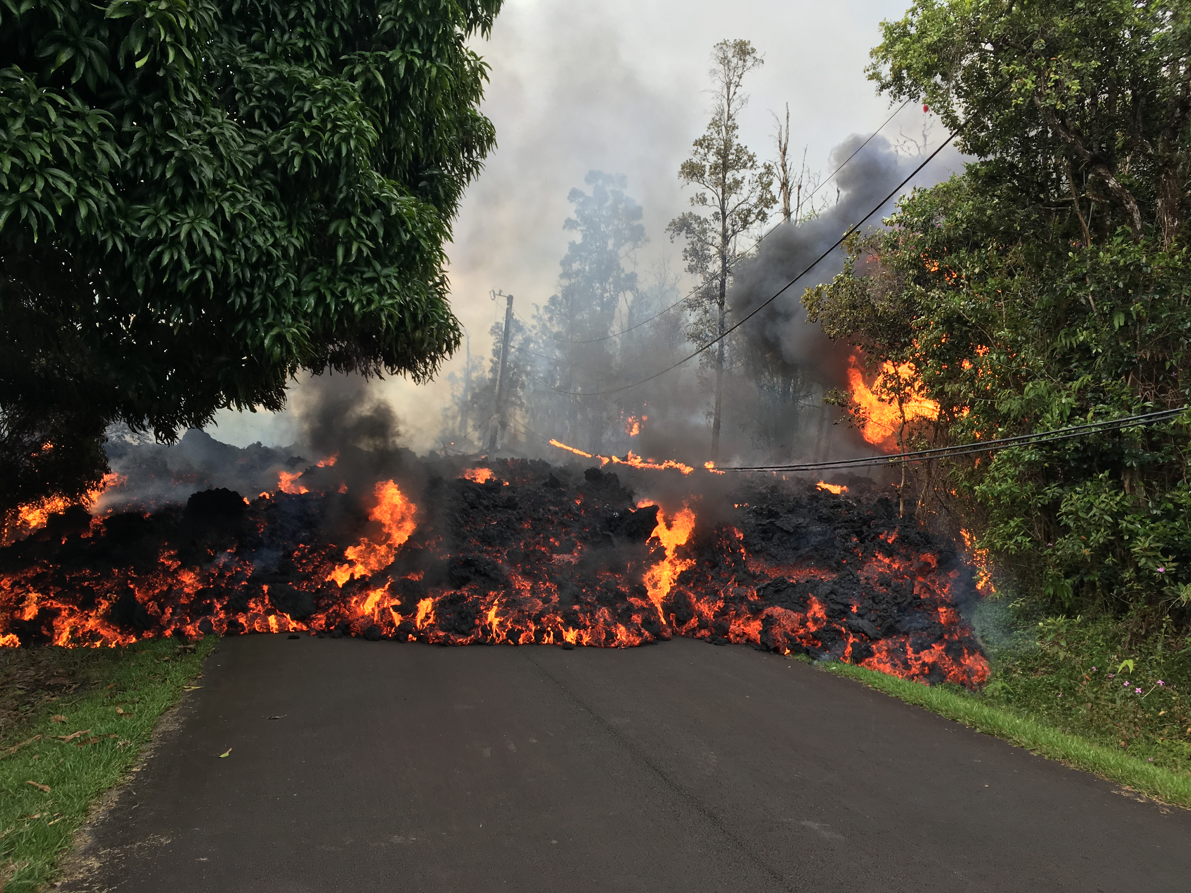
 Lava flow on Makamae Street, HI, from the 2019 Kilauea eruption. In this unit, students will analyze the volcanic hazards, population characteristics, and infrastructure vulnerabilities for a series of volcanoes. Image from USGS
 ![[creative commons]](/images/creativecommons_16.png)
How are we able to asses risk level of certain volcanoes to their surrounding communities? In this unit, you will assess the risks specific to a series of volcanoes with varying properties based on the Risk equation: Risk = Hazard x Value x Vulnerability. Your final product will be a table that helps one to identify the volcano at greatest risk, taking into consideration the volcanic hazards, population characteristics and infrastructural vulnerabilities for the communities surrounding each volcano.
- Pre-Reading on Eruption Types (Microsoft Word 2007 (.docx) 6.2MB Feb3 23) and complete work using the Student Answer Sheet (Microsoft Word 2007 (.docx) 193kB Jul3 19) (or on the reading depending on your instructors preferences).
- In Class Handouts (different groups will receive different readings)
- Fuego handout (Microsoft Word 2007 (.docx) 13.3MB Jul16 24)
- Rinjani handout (Microsoft Word 2007 (.docx) 11.5MB Jul16 24)
- Mauna Loa handout (Microsoft Word 2007 (.docx) 8MB Jul15 24)
- Student Worksheet for all groups (Microsoft Word 2007 (.docx) 312kB Jul16 24)


