Ideas for Teaching with Datasets, Simulations or Models
Visualizing Polar Change: Data and Tools to Understand an Arctic Climate in Transformation
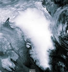
by Walt Meier, National Snow and Ice Data Center The Arctic is undergoing a rapid change, which will have dramatic implications for the Arctic climate and beyond. NSIDC has numerous datasets and visualization tools that can be used to track and understand this change and its implications. This presentation focused on Arctic sea ice, the most dramatic climate change indicator.Download PowerPoint presentation (PowerPoint 6.2MB Feb25 08)
Activity Ideas

GeoMapApp: A new virtual globe designed especially for earth and environmental science education
by Andrew Goodwillie, Lamont-Doherty Earth Observatory of Columbia UniversityThis java application is now updated with a spinning 3-D globe visualization capability. GeoMapApp is now integrated using Web Mapping and Web Feature Services with hundreds of large datasets and grids that reveal knowledge about the surface of our planet both on land and beneath the oceans. The talk will briefly demonstrate interactive tools for exploring seafloor bathymetry, sub-bottom reflection profiles, rupturing of seafloor at spreading centers by earthquakes, the properties and kinematics at plate boundary and volcanism at convergent margins.
Description of how to use GeoMapApp
Activity Ideas
- Compare Data for Plate Tectonics
Feature Exploration on the Seafloor
Seafloor Sediment Thickness Variability
How much work to learn about the Earth?
Marine research proposal
Lithospheric flexure in Hawaii
Continental and oceanic heat flow
Chemistry of continental vs. oceanic rocks
 Graphic showing some of the data sources available in NASA's Giovanni web portal Details Giovanni: Satellite-Based Earth Science Data in the Classroom
Steven Lloyd - NASA Goddard Earth Sciences Data and Information Services Center

Giovanni is a web-based application developed by the NASA Goddard Earth Science Data and Information Services Center. This tool provides a simple way to visualize, analyze and access vast amounts of satellite-based Earth science data. The presentation below highlights Giovanni's features and provides examples of its use, with an emphasis on how satellite remote sensing can help us understand recent events in the atmosphere and biosphere.
- Download PowerPoint presentation (PowerPoint 2.4MB Feb11 08)
Jim Acker Presentation on Ocean Color Data (PowerPoint 2.8MB Jul22 05)
Activity Ideas
- Will I need an umbrella?
Regional water cycle exploration with Giovanni
Where in the World is El Nino?
Comparing Rainfall Trend
Exploring local, regional, and seasonal hydrology
Using 3D and 4D Exploration and Visualization of Geoscience Data with the GEON Integrated Data Viewer
Stuart Wier, UNAVCOThis is a powerful tool for exploration and display of data in solid earth and atmospheric sciences. The GEON Integrated Data Viewer (IDV) accepts most any earth-located data, including 2D, 3D, and 4D grids and model output, point observations, and tracks and soundings. UNAVCO has enhanced the IDV to display, for example, earthquakes hypocenters, focal mechanism "beachballs," GPS velocity vectors, plate boundary strain rates, three-dimensional seismic tomography, and mantle geodynamic model results.
Activity Idea
USGS Data Sets: Applications for the Classroom
Matthew Arsenault, Woods Hole Science Center, U.S. Geological SurveyThere are many earth science data sets freely available from the U.S. Geological Survey that can be useful for teaching.
Activity Ideas
- Shoreline and Sea Level Change
Exploring the ocean floor and near shore societal issues using data sets
Creating an integrated dataset for Long Island Sound
Data Sources