Cracked, Bumpy and Beautiful: Earth's Surface
This activity benefited from feedback during the development process.
This activity benefited from feedback from peer teachers and instructors during its development and implementation as a part of the Earth and Space Science professional development course. For more information on the process, see http://serc.carleton.edu/spaceboston/review.html.
Initial Publication Date: June 6, 2018
DOIThis page currently has no DOI, but you may request a DOI be assigned. |
Cite thisSummary
Using a variety or resources, students will plot the locations of mountain ranges,volcanoes and major earthquakes on a class map. Students will then hypothesize what may be creating concentrated areas of these occurrences. We will then connect this information, using an overlay, to the earth's crustal plates and their movement.
Learning Goals
~Students will relate changes in the earth's surface (ie: formation of mountains along with volcanic eruptions and earthquakes)to the existence of crustal plates and movement.
Context for Use
This lesson is created for middle school age children (used in 6th grade). It is created for a class size of approximately 22 students, heterogeneously grouped. Within the class this lesson is structured for students to work in blended cooperative groups of 3-4 students. This class activity is expected to occur over three days, with class periods of one hour daily.
Prior to implementing this lesson students should be familiar with world maps and reading latitude and longitude lines. Students should have some prior work plotting coordinates on a map.
Lessons and investigations prior to this lesson will ensure that students have developed an understanding of the following:
- The solid earth is layered with a lithosphere; hot, convecting mantle; and dense, metallic core.
- Earth's crust consists of numerous plates, which fit together to cover the surface. These plates sit atop the asthenosphere.
Background
Earth is comprised of layers. For the purpose of this age level these layers are; core, mantle, lithosphere (crust). The lithosphere is the rocky outer shell of Earth, which is made up of the crust and rigid upper part of the mantle (only 5% of Earth's total mass). This layer consists of numerous plates which fit together like a jigsaw puzzle. There are two kinds of crustal plates; the heavier, more dense oceanic plates and the thicker less dense continental plate.
Oceanic crust = basalt, an igneous rock produced by melting from the mantle
Continental crust = made of lower density rocks
The lithospheric plates sit atop the mantle. The upper part of the mantle is solid, but because it is warm and its pressure is low, it is softer and flows more easily than the crust. At different point, parts of the upper mantle melt due to pressure. This melting causes the outer pieces of earth to shift. Further information about convection currents and their impact on this process may be helpful for the teacher to understand.
.
This lesson focuses on children developing an understanding of the results of the shifting of plates and impact that this movement has on the surface of our planet. The place at which the plates meet is referred to as the plate boundaries. The type of boundary depends on whether the plates forming them are moving toward each other, separating, or sliding past each other.
- Convergent boundary: when two plates collide. The pressure of this convergence produces mountains and bands of earthquake and volcanic activity.
- The movement of one plate sliding below another is called subduction. When a plate subducts, the rocks in the plate are pushed deep into Earth where they're heated and recycled back into the mantle.
- Divergent boundary: forms where tow plates diverge, or move apart. Melted rock can come to the surface at divergent boundaries and form new crust. These boundaries occur mainly between ocean crusts. Mid-ocean ridges, undersea mountain ranges, are formed at this boundary.
- Transform boundary: forms where two plates slide past each other. This sliding causes rocks along the boundary to grind against each other causing earthquakes.
Lithospheric plates constantly move at rates of centimeters per year in response to movements in the mantle. Major geological events, such as earthquakes, volcanic eruptions and mountain building, result from these plate motions
For historical information into the development of the theory of plate tectonics visit http://www.geo.ua.edu/intro03/plate.html
Description and Teaching Materials
In-Class Activities
1. Each student will "draw" the name of a volcano, earthquake and mountain/mountain range. Students will work within groups of 3 to locate the geographic coordinates of each of their assignments. Computer access will be given to each group with a compiled hotlist to ensure focused research. Print resources will also be available.
2. Once each student has found their coordinates they will place a stickers on the class map (poster) to represent each:
a. red circle – volcano
b. yellow rectangle – earthquake
___________ - mountain/mountain range
3. Upon completion of the class map, a class discussion should occur to elicit student observations and thoughts about the data. Students should be encouraged to share their ideas about the causes of volcanoes and earthquakes along with sharing their thoughts about how mountains are formed.
4. After sufficient discussion the teacher will plate a clear overlay onto the map, this overlay will have the lithospheric plates drawn along with arrows depicting the direction of the movement of these plates.
5. Students should be given ample time to review this new information and once again be asked to make connections between the information that is depicted on the class map.
6. Students will be given a Guided Reflection Sheet upon which they will respond to the following questions:
a. Observe the pattern of earthquakes and volcanoes over the surface of the Earth. Are they scattered at random or are they concentrated in certain areas? Describe your observations.
b. Describe the distribution of earthquakes and volcanoes in relation to the continents.
c. Is there a relationship between the direction of the plate movement and the occurrences or earthquakes and volcanoes? Describe and explain.
d. Why do you think you were asked to locate mountain ranges on this map? What might be the relationship to crustal plate movement?
7. Following Day: Students will complete an "Act-It-Out" in groups of three students. Each group will "draw" the name of a boundary and act out the action and possible result at this boundary.
At Home Assignments
Students will visit the following website to review the theory of plate tectonics and the different plate boundaries. Students should complete notebook sketches and descriptions for each.
cotf.edu/ete/modules/msese/earthsysflr/plates1.html (link down)
Students will be asked to develop a minimum of three discovery questions. These questions should reflect their personal interest as related to the information gleaned during the mapping activity. Emphasis will be place on "researchable" versus "investigable" questions. (previously introduced)
Materials
- List of major earthquakes
- List of largest volcanoes
- Each of the above lists should include no fewer than 25 of each, earthquakes and volcanoes should be hand selected by the teacher to ensure easily found on the given map and to help demonstrate the locations of plate boundaries
- List of major mountain ranges
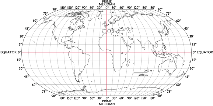
- Four poster size copies of black line world map with latitude and longitude coordinates (laminated)[uploaded here]
- Plastic overlay (poster size) with crustal plates outlined and plate directional arrows
- Small red stickers to represent volcanoes
- Small yellow rectangle stickers to represent earthquake epicenters
- ________________________stickers to represent mountain ranges
- Clear plastic overlay, made the same size as the poster. This overlay should show the tectonic plates and the direction of their movement
- Students access to computers, atlas materials and other reference books.
- List of Volcanoes, Earthquakes and Mountain Ranges used for plotting ~ Uploaded :my file (Excel 35kB Jun26 10)
Standards
MA: Earth and Space Science, Grades 6-8
1. Recognize, interpret, and be able to create models of the earth's common physical features in various mapping representations, including contour maps.
5. Describe how the movement of the earth's crustal plates causes both slow changes in the earth's surface (e.g., formation of mountains and ocean basins) and rapid ones (e.g., volcanic eruptions and earthquakes).
Teaching Notes and Tips
The follow up lesson to this activity will include a "draw with me" notes discussion to ensure that each child has accurately depicted the various plate boundaries. This discussion will introduce the theory that convection currents along with the "pull" and "push" are responsible for the shifting plates. This lesson will introduce the earlier theory proposed by Alfred Wegner as Continental Drift. We will follow up with a terrific activity I have previously used, adapted from a lesson found at Windows to the Universe. Students will be allowed to research a volcano, earthquake area or mountain range to create a travel brochure which outline the features of the land form and geographical information.
Assessment
- Students will complete a reflection writing with guided questions. This work will be assessed based on the ability to demonstrate an understanding of crustal plate movement as related (geographically) to volcanoes, earthquakes and the formation of mountain ranges.
- Students will develop "Discovery" questions they want to investigate and/or research based on the activity. This will eventually lead to individual work/research on an area of interest. Upon completing their work students will create travel brochures for the "extreme traveler".
- Students' conceptual understanding of this activity will be applied to further inquiry and study of plate tectonics, and convection currents as related to the mantle.
References and Resources
Elkins-Tanton, Linda T. The Earth and the Moon. New York: Chelsea House, 2006. Print.
Sciencesaurus a Student Handbook. Wilmington, MA: Great Source Education Group, 2006. Print.
http://www.ngdc.noaa.gov/nndc/struts/form?t=101650&s=1&d=1
The Significant Earthquake Databasecontains information on destructive earthquakes from 2150 B.C. to the present that meet at least one of the following criteria: Moderate damage (approximately $1 million or more), 10 or more deaths, Magnitude 7.5 or greater, Modified Mercalli Intensity X or greater, or the earthquake generated a tsunami.
http://www.volcano.si.edu/world/list_allnames.htm
The Global Volcanism Program Database currently contains 1587 volcano names (1545 Holocene and 42 Pleistocene with thermal activity) (bolded), 1995 synonyms, and 9290 subfeatures, for an overall total of 12872 names, sorted below in alphabetical order. Descriptions of the various "Volcano Type" and "Volcano Status" designations can be found on the http://www.volcano.si.edu/world/volcanocriteria.cfm page.
http://www.worldatlas.com/aatlas/infopage/latlong.gif
Blank Map with Longitude and Latitude lines. Download free of charge then increase size to Poster.
http://geology.com/plate-tectonics/
This is a terrific site to use for enrichment activities and for additional background for teachers.
cotf.edu/ete/modules/msese/earthsysflr/plates1.html
This link will be used for the homework assignment. This site is written for a younger audience and includes clear descriptions and graphics.
Copyright © 1999-2003, Wheeling Jesuit University/Center for Educational Technologies®. All rights reserved.
Center for Educational Technologies and the COTF/Classroom of the Future logo are registered trademarks of Wheeling Jesuit University.
http://www.usgs.gov/
Welcome to the USGS - U.S. Geological Survey. Web. 24 June 2010. .
Cracked, Bumpy and Beautiful: Earth's Surface --Discussion
G'Day Lisa:
Some random reactions from a non-scientist as he reads though things ...
1. Great project idea. Good stuff.
2. BACKGROUND: "This melting causes the outer pieces of earth to shift." I think, when you get the chance, it would be worth explaining what you mean by this a little more. Maybe make the mention of ridge push and slab pull, which, if I understood Lindy's lectures correctly is a cause of melting rather than melting being the cause. I think kids can understand the idea of slab pull.
3. IN-CLASS ACTIVITY: I don't know if this would ever be a problem, but what defines an mountain range? The blue-ridge mountains in the Carolina's count? The white mountains? The Berkshire's? Could this be a cause of difficulty? (I don't know.)
4. ASSESSMENT: It might be helpful for other teachers reading this activity to know what "guided questions" you are going to provide. I love the "extreme traveller" idea!
Super stuff!
- J
3640:12757
edittextuser=3827 post_id=12757 initial_post_id=0 thread_id=3640
Some comments from Lindy --
gorgeous work, as usual!
Being clear how you use "lithosphere" and "crust" is important to learning these ideas, I find; they are not always used consistently in education or research. Crust, as we know, is compositionally different from the mantle. Lithosphere includes both the crust and some buoyant, melt-depleted mantle material (the mantle lithosphere) stuck together, and moving together as a plate. In the background section you imply lithosphere and crust are synonyms, so that should perhaps we rewritten.
In background you also say that the upper mantle sometimes melts "because of pressure" - I wonder what a better way is to say this. Perhaps just leave it at "melts" for this age group, or explain that as mantle moves toward the surface the reduction in pressure can allow it to melt.
Also in background you mention specifically that earthquakes happen at transform faults - absolutely true. They also occur at all other kinds of boundaries, too, including divergent, if only because of magma movements in most cases. There is a great map you can get of earthquakes, and they cluster along all the boundaries.
And I have a similar question about the mountain ranges idea. Indeed mountain ranges can be created by various processes, including thrust faulting at convergent boundaries (e.g. the Himalayas, the Appalachians), but also by volcanoes and subduction zone processes (modern Andes, plus lots of complex activity there from the past). You did mention that you will choose the mountain ranges to be most pertinent. There will be overlap between volcanoes and mountains, therefore, since the two are redundant in part; this might take some discussion in class. There are other mountain chains whose causes are not understood at all - there's an east-west chain in Utah (I can't think of its name) that defies explanation at the moment.
The resources are very good. You might also look at the IRIS seismic monitoring website:
http://www.iris.edu/seismon/
all my best -
Lindy
3640:12777
edittextuser=3776 post_id=12777 initial_post_id=0 thread_id=3640
Thank you both for the information and ideas. I will definitely incorporate your thoughts and take a look at the website.
Lindy - I like your suggestion about the mantle. I will also clarify the background piece about the Lithosphere vs the Crust, I didn't mean to have that sound synonymous.
I'll get these change in next week...I'm fully into my next class...Inclusion.
Have a safe trip and again...thanks for all your thoughts and support.
3640:12830
edittextuser=3856 post_id=12830 initial_post_id=0 thread_id=3640
Hello Lisa -
Actually marking features on a class map and then seeing what it all looks like seems to me a great way to engage kids in thinking about this topic. As the number of "dots" grows, I expect kids will be excited and raise questions.
I also think a wide range of learners will be well-served by this activity, and I know you care about that.
I think the one potential pitfall is that when you eventually overlay the transparency with the plate boundaries drawn in, some kids could feel that there was a "right answer" you had in mind all along - that they were illustrating a point rather than investigating a real question.
If you care to avoid this, some small changes might help (you may already have these in mind).
One would be to take all (or at least a few) of the ideas students propose about causes and ask how they might find support for each. Try out those ideas. (Lining up the plates with the map you've made encourages a connection between the plate boundaries and features you've mapped. What other ideas might kids propose, and what information or overlay would they need to compare in each case?)
Even though students already know about the plates, and may well bring up this connection themselves, it might still be good to consider whether anything else could explain the pattern. (I'm not sure what would serve well in this regard, but for the sake of example: how do the clusters of volcanos/earthquakes/mountains relate to equator/poles? Got any ideas, Lindy, Jim or others?)
Maybe it is as simple as making sure to map some of the mountain ranges, like the oine in Utah that Lindy mentioned, that don't lie along the plate boundaries on your overlay.
Regarding your questions under 6:
I prefer the wording of a and b to d, because it focuses students on their observations/descriptions rather than your motives. Easy to change d if you care about this ("What do you notice about the location of mountain ranges..." or something like that).
Looking forward to hearing what your students do and think!
Ellen
3640:12854
edittextuser=3872 post_id=12854 initial_post_id=0 thread_id=3640
Join the Discussion
Log in to reply
