Unit 2: Processes of ice margin retreat and elevation/thickness change
Summary
Processes of ice margin retreat and elevation/thickness change
In Unit 2, students begin to use GIS as a research and learning tool, exploring the landscape surface via satellite imagery and identifying erosional and depositional features. Connections are made between landscape surface features and the ice sheet history of advance and retreat. Students also use an Arctic Digital Elevation Model (DEM) tool to consider how ice elevation can inform their understand and make further connections across ice sheet behavior, climate, and landscape character.
Learning Goals
Driving Question: What are the distinguishing features of the land surface for ice margin regions of a glacier basin system?
Learning Goals: Describe ways in which glacier advance and retreat reshape the bedrock and sediments in regions of recently active ice cover
Context for Use
The content in Unit 2 is appropriate for upper division geology, environmental sciences, meteorology, and other geoscience courses; junior/senior-level courses in which geomorphology, climatology, or glacial geology studies are building on prior introductory material. Unit 1 activities can easily be adapted to serve small- or large-enrollment classes and can be executed in lecture and lab settings as an interactive lecture activity, an in-class activity in which students work in small groups, a short lab exercise, or as part of a ~three-week investigation incorporating GIS and Interactive Environments to understand a glacier basin system and cryosphere using the entire Exploring the Glacier Basin System module. This is the second Unit in the Long-term Spatial Transformations of the Glacier Basin System module and explores the distinguishing landforms of the ice margin region and how glacier advance and retreat reshape the bedrock and sediments in regions of recently active ice cover.
Description and Teaching Materials
Part 1: Processes driving ice margin, elevation, and thickness change
Exploring GIS and an online tool to examine ice edge changes over multiple decades. This exploration should be integrated with discussion of ice sheet mass balance, melt, and ice sheet edge changes across varying environments (e.g., marine-terminating glaciers, land-terminating glaciers, other ice edge regions).
- Videos: Research on past Greenland Ice Sheet extent, and advance/retreat-
- Image Slide Deck: Processes of ice margin retreat and elevation/thickness change Mod2 Unit2 Part1 Processes Ice Margin Change.pptx (PowerPoint 2007 (.pptx) 147MB Nov16 22)
Part 1 exercises use the QGreenland QGIS environment. Follow these instructions to install these tools: Mod 1 GIS Setup Instructions.pdf (Acrobat (PDF) 2.3MB Dec8 21)
- Exercise/QGIS: Multi-decadal glacial margin change exploration activity:
- GIS: Mod2 Unit2 Part1 Multidecadal Landsat Images.zip (Zip Archive 13MB Feb17 22) Landsat satellite imagery data files.
- Interactive Website: https://jmleaglacio.users.earthengine.app/view/greenlandglacierchange A neat tool that students could use to look at image comparisons in (somewhat random) locations all around Greenland
Part 2: Determining Glacier Advance/Retreat from Landforms
Students explore and identify erosional and depositional landforms in ice margin images and based on glacial features determine if ice is advancing or retreating or stable. (These landforms are one way we identify advance/retreat).
- Videos: Reading the Landscape, Signs from Glaciers Past by Dartmouth/IGERT and Meredith Kelly
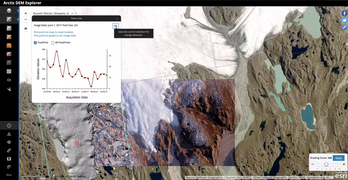
- ArcticDEM Elevation Explorer: https://livingatlas2.arcgis.com/arcticdemexplorer/
- Students identify elevation transects across landform features at the ice margin and elevation change at a specific margin location (e.g. Russell Terminus)
- Exercise: Arctic DEM Explorer tool to identify glacial landform features and measure surface elevation changes
- In addition, use GoogleEarth Pro to explore and identify recent erosional and depositional landforms indicating current ice margin changes for close-up views (tip: select Historical Imagery)
![[creative commons]](/images/creativecommons_16.png)
What we learned:
- Recognize the natural factors that cause glaciers/ice sheets to advance and retreat
- Identify types of erosional and depositional landforms that indicate ice advance, stability, or retreat
Teaching Notes and Tips
This Unit centers around interactive student activities that include GIS and online tools, and doesn't provide materials for a full lecture. Plan for this to be interactive, whether doing the activities together or focusing classtime on discussion.
Within this Unit, students will encounter data that may not align with expectations (e.g., using the DEM explorer). Consider using this to discuss challenges in collecting data and ways in which scientists might encounter and work with errors, measurement uncertainties, and surprise observations.
Students may also feel challenged to identify small changes in large landscapes (e.g., using satellite images). This can provide an opportunity to discuss spatial scales, the importance of detailed observations, and connections between small local changes and the cumulative effects they may have on a larger scale.
Tips from Other Instructors
- Convert the Arctic DEM Explorer exercise to an in-class, non-graded activity to provide engagement as a full class.
Assessment
Assessment: Mod 2 Unit 2 Assessment.docx (Microsoft Word 2007 (.docx) 419kB Oct5 23)
- Mod 2 Unit 2 Rubric.docx (Microsoft Word 2007 (.docx) 19kB Oct5 23)
Sketch map and cross-sections: Students consider the relationship between glacial advance and retreat and associated landforms over time and space.
References and Resources
Greenland Glacier Change: https://jmleaglacio.users.earthengine.app/view/greenlandglacierchange
ArcticDEM Explorer: https://livingatlas2.arcgis.com/arcticdemexplorer/
MyGeodata Converter: https://mygeodata.cloud/converter/ is a useful tool for converting Geo-referenced pdfs (exported from QGreenland) into GeoTiffs.tif that can them be uploaded into GoogleEarth Pro (desktop version)