For the Instructor
These student materials complement the Coastal Processes, Hazards and Society Instructor Materials. If you would like your students to have access to the student materials, we suggest you either point them at the Student Version which omits the framing pages with information designed for faculty (and this box). Or you can download these pages in several formats that you can include in your course website or local Learning Managment System. Learn more about using, modifying, and sharing InTeGrate teaching materials.Blended
Beach Profiling Exercise
Beaches evolve or change through time due to both natural forces and man-made engineering. Coastal geologists and engineers evaluate how sediment is deposited, eroded, and transported along coastal beaches and barrier islands to better understand the processes that drive these kinds of changes. One method that is commonly used to evaluate and understand beach evolution and sediment transferal is to repeatedly measure the elevation of the beach. This can be done a number of different ways but one of the historically quickest and cheapest methods is to use the Emery beach profiling technique, which was developed by K.O. Emery in 1961. This YouTube video provides a good explanation of the procedure that is used to obtain data for the elevation of a beach.
This YouTube video provides a good explanation of the procedure that is used to obtain data for the elevation of a beach.
http://www.youtube.com/watch?v=NaF7Pq2HkxA
Here is another link describing Emery (1961) method of beach profiling.
http://www.whoi.edu/seagrant/page.do?pid=52235&tid=282&cid=88638
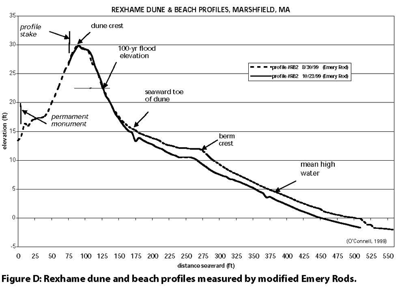
Collected data can be plotted to show a cross sectional profile of the beach at the time of surveying. If the beach is surveyed multiple times at different time periods, a record of the changes in the cross sectional picture of the beach emerges. Comparing the cross sections for different survey dates enables one to determine whether the elevation of the beach has been locally reduced because of erosion or if the elevation of the beach has locally increased, implying deposition at this location. Take a look at this enlarged plot from the previous link to fully understand the type of cross sectional plot that can be created with the beach profiling technique http://www.whoi.edu/cms/images/rexhame2_126638.gif
Be certain to look at the links provided above before attempting this assessment.
When multiple profile transects are set up and surveyed repeatedly along the length of a beach, then it is possible to determine how different sections of the beach evolved. For example, suppose you have two different profiles set up along a beach with 1 kilometer spacing between them. At the first profile location, repeat surveys show that there is net erosion on the beach face, whereas at the second profile location, a kilometer away, there was deposition. One might interpret the increase of sediment volume at the second profile a result of sediment being eroded from the first location and transported to the second location. In this exercise, you are given beach profile survey data for three different transects along Integrate Island. The three transects are 500 m apart from one another and each transect was surveyed three times (Figure 3.49). The first survey was completed on February 1, 2008 to establish a baseline elevation dataset for each profile location. The second survey was completed on September 9, 2008. Although the second survey was only 6 months after the first survey, there was a category 3 hurricane late in the summer of 2008. Hurricane Alberto made landfall just 100 km away from Integrate Island and caused significant changes to the elevation of the island due to large waves and a 2 meter storm surge. The final survey was completed on November 1, 2009.
 Figure 3.49: Location of the three elevation transects surveyed on Integrate Island. The image was taken the day of initial survey on February 1, 2008.
Credit: Enter image credit here
Your goal for this exercise is to take the raw survey data for the island and plot it in Excel. When finished, you will have three different plots, one for each beach profile transect, and each plot will have three different elevation profiles overlaid upon one another so that you compare the changes in elevation for the three time periods (one for 02/01/2008, one for 9/9/2008, and one for 11/01/2009). Once you have all three plots constructed, you can answer the questions that are at the end of this assignment.
Note: You will need to download the document below to complete your assignment and turn it in to be graded.
Files
Download the Spreadsheet (Excel 76kB Sep7 16)
Download this Worksheet (Microsoft Word 2007 (.docx) 2.8MB Sep7 16)
Download this Rubric (Microsoft Word 2007 (.docx) 16kB Sep7 16)
