For the Instructor
These student materials complement the Coastal Processes, Hazards and Society Instructor Materials. If you would like your students to have access to the student materials, we suggest you either point them at the Student Version which omits the framing pages with information designed for faculty (and this box). Or you can download these pages in several formats that you can include in your course website or local Learning Managment System. Learn more about using, modifying, and sharing InTeGrate teaching materials.Questions
Answer the questions in the worksheet that you downloaded earlier.
Physical Vulnerability Questions
1) Based on the screenshot below, in which of the following boxed areas (A-D) will 4 ft of sea level rise cause the most extensive flooding?
A. Coral Gables
B. Downtown Miami
C. Miami Shores
D. Miami Beach
2) Based on the screenshot below, in which of the following boxed areas (A-D) will 4 ft of sea level rise cause the least extensive flooding?
A. Coral Gables
B. Downtown Miami
C. Miami Shores
D. Miami Beach
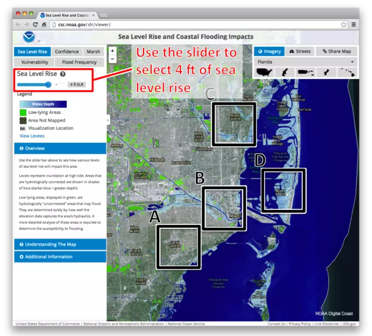 Figure 12.20: Sea Level Rise and Coastal Flooding Impacts (5).
Credit: NOAA
Next, click on the vulnerability button in the upper-left to show the SoVI scores for the Miami area. (After switching to the SoVI view, you may want to drag the sea level rise slider all the way to the left, to the "0" or "Current MHHW" setting, so that the light blue sea level inundation layer does not obscure your view.) SoVI scores are shown in three categories, High, Medium, and Low; areas with High scores are dark red, areas with low scores are light red.
Social Vulnerability Questions
3) Based on the screenshot below, which of the boxed areas (A-D) has the greatest extent of high social vulnerability?
A. Coral Gables
B. Downtown Miami
C. Miami Shores
D. Miami Beach
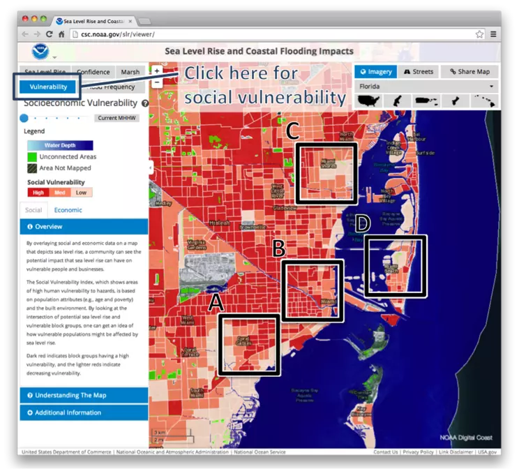 Figure 12.21: Sea Level Rise and Coastal Flooding Impacts (6).
Credit: NOAA
Combined Vulnerability Questions
Combined Vulnerability Question:
4) Based on both of the above screenshots, which of the boxed areas (A-D) appears to have relatively low social vulnerability and moderate (neither highest nor lowest) physical vulnerability?
A. Coral Gables
B. Downtown Miami
C. Miami Shores
D. Miami Beach

