
Unit 2: What Does GPR Data Look Like?
Summary
GPR imaging is more complex than is portrayed in the media. This unit describes what the GPR response for a buried object looks like. This is a distorted image of the object itself. Nevertheless, the response we do get can give us a good amount of information about the location of the buried object. The unit explains why the GPR response takes the shape that it does. Most importantly, students learn that the shape of the response is controlled by the velocity of EM waves in the ground, which is not the same everywhere. If you know the ground velocity and the travel time of the GPR signal reflecting off a buried object, you can calculate the depth of a buried object. Students can practice this using an online app with real data.
Learning Goals
![[creative commons]](/images/creativecommons_16.png)
Students will be able to:
- Recognize the direct wave and diffraction patterns in GPR data.
- Describe the relationship between diffraction pattern shape and ground velocity.
- Interactively fit a hyperbola to a diffraction pattern to determine a single-velocity model and then convert two-way travel time to depth, using an online app with real data from buried utilities, graves, tree roots, and volcanic blocks.
- Explain why knowing the depth of a buried object may be very important.
Context for Use
This unit is intended for undergraduate students with no previous exposure to geophysics. There is no math or science prerequisite.
The instructor can expect to spend 1–2 class periods with this material depending on class length and size. Student material may include background reading provided as links in the presentation. The instructor also has the option to use the examples of GPR in engineering and forensic application for class discussions. Assessment activities may be done in groups or as individuals.
Involves students running several apps online.
Description and Teaching Materials
Introduction and worksheet
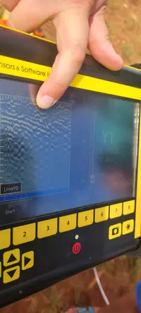
The teaching material includes a PowerPoint presentation with links to external resources, including YouTube videos and an interactive app that provide additional instructional content. The videos are animations of GPR wave propagation in different settings and the resulting radargrams. The interactive app allows students to set the depth of a buried pipe and ground velocity and view the expected diffraction pattern. Because of embedded content, the file size is very large.
- What does GPR data look like? (PowerPoint 2007 (.pptx) 30.9MB Jul16 25)
- GPR point-reflector animation (MP4 Video 3MB Jul23 25)
- GPR layer-reflector animation (MP4 Video 2.3MB Jul23 25)
The following worksheet is designed to be completed as students follow along with the slide presentation or outside of class and refer to the slides. This worksheet may also serve as a source of quiz or test questions if desired. Think-pair-share questions are best implemented during class time. These may also serve as short essay questions to be answered individually.
- What does GPR data look like assessment questions (Microsoft Word 2007 (.docx) 187kB Sep15 24)
Data analysis exercise: Estimating Depth of Features in GPR Profiles
The data analysis exercise may be completed with example data provided here or data collected by the instructor and/or students. The example data comes from GPR surveys locating utility lines under a paved road, unmarked graves belonging to a forgotten cemetery, tree roots above an irregular clay layer, and volcanic blocks within volcanic deposits. This exercise requires that students access the GPR fit app.
- Data analysis exercise, Estimating Depth of Features in GPR Profiles (Microsoft Word 2007 (.docx) 103kB Sep15 24)
There is an opportunity in this module to assign a writing exercise. Students may be asked to write a (short) technical report presenting the results of their data analysis. If students use their own data, ask them to describe the survey objectives, expectations, and methods. The results can be the data analysis similar in type to the analysis performed in the data analysis exercise.
Teaching Notes and Tips
Some important concepts that may benefit from additional discussion:
- GPR rays go out in all directions, but the data are plotted assuming the reflections come from directly below the antenna. This is the source of the distortion in GPR images.
- An object may "look" different depending on the orientation of the GPR profile over the object.
- The information you get from GPR data is very much dependent on the ground's properties and not just the target of interest. Geology and soil matter!
- The reflected signal is a pulse with successive peaks and troughs and not a single peak amplitude.
- Students may not immediately see the connection between the GPR cart moving along a transect and how the radargram is produced.
Contextualizing the use of GPR to locate unmarked graves
One of the case studies in this module involves the use of GPR to evaluate a site for the presence of unmarked graves. Unmarked grave sites in the United States include cemeteries for enslaved people, where slaveholders typically made no effort to mark or protect burial sites, and cemeteries on the grounds of "Indian boarding schools" run by U.S. government agencies, where Native American students were buried without their families' knowledge or consent. The module overview page has contextual information about using GPR to locate unmarked graves and incorporating this content into your teaching, and a list of references you can explore to learn more.
Assessment
Student learning can be assessed via answers to the student worksheet (with questions about the introductory presentation) and student solutions to the data analysis exercise:
- What does GPR data look like assessment questions (Microsoft Word 2007 (.docx) 187kB Sep15 24)
- Note: This is the same file as is linked above, in the Teaching Materials section of this page.
- Data analysis exercise, Estimating Depth of Features in GPR Profiles (Microsoft Word 2007 (.docx) 103kB Sep15 24)
- Note: This is the same file as is linked above, in the Teaching Materials section of this page.
The guided questions in the data analysis assignment can be formatted into an optional technical report where students write as if they are presenting their data analysis to a client or collaborator. Through a combination of technical writing and figures, the report will identify the target of interest (and why GPR is useful), describe how the data was collected, list the processing steps employed by the student, present results (number of buried objects and their depths), and give a discussion of how the results meet the survey objective. If applicable, students can offer a discussion on data interpretations.
Solutions for instructors
References and Resources
Resources
- Interactive app that draws the diffraction pattern produced by a buried pipe at a user-selected depth and ground velocity.
- The interactive GPR Fit app allows users to fit diffraction hyperbolas in real data.
- Geosci.xyz is an open-source educational resource for the geosciences. The site provides a comprehensive explanation of GPR theory that the instructor may refer to as needed to expand on this unit.
References
Explore references about African-American slave cemeteries and Native American boarding schools on the module overview page.


