Introduction to Modeling Folds
Basil Tikoff, University of Wisconsin-Madison
Naomi Barshi, University of Wisconsin-Madison
Carol Ormand, SERC, Carleton College
This activity was selected for the On the Cutting Edge Reviewed Teaching Collection
This activity has received positive reviews in a peer review process involving five review categories. The five categories included in the process are
- Scientific Accuracy
- Alignment of Learning Goals, Activities, and Assessments
- Pedagogic Effectiveness
- Robustness (usability and dependability of all components)
- Completeness of the ActivitySheet web page
For more information about the peer review process itself, please see https://serc.carleton.edu/teachearth/activity_review.html.
Initial Publication Date: March 10, 2020 | Reviewed: December 10, 2020
- First Publication: March 10, 2020
- Reviewed: December 10, 2020 -- Reviewed by the On the Cutting Edge Activity Review Process
|
Cite thisSummary

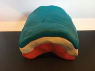
Play-Doh model, upright anticline
![[creative commons]](/images/creativecommons_16.png)
Provenance: Carol Ormand Ph.D., Carleton College
Reuse: This item is offered under a Creative Commons Attribution-NonCommercial-ShareAlike license http://creativecommons.org/licenses/by-nc-sa/3.0/ You may reuse this item for non-commercial purposes as long as you provide attribution and offer any derivative works under a similar license.
Students make Play-Doh models of synclines and anticlines, including one of a plunging fold. They use these models to answer questions about what these structures look like in map view and cross-sectional view.
Context
Audience
200-level undergraduate course, "Introduction to Geologic Structures." This course is a pre-requisite for most upper-level undergraduate geoscience courses in the core curriculum, including Structural Geology. It has a pre-requisite of an introductory level Geology course.
Skills and concepts that students must have mastered
Familiarity with the definitions of common types of folds is helpful, but we also review those definitions during the activity.
How the activity is situated in the course
This activity is a "review" of folds, which students are expected to have learned about in their introductory Geology course. It builds on this review to remind students that structures exist in three dimensions, and that their appearance differs depending on our visual perspective. It also allows us to review related terminology.
Following this activity, I describe and define domes and basins as well, and we discuss how they appear in map view and in cross-section. I then show a series of photographs of outcrops and ask students to identify the folds in each of the images. This class period immediately precedes our field trip to the Black Hills, where students will see many kinds of folds. Later in the course, we return to folds using more complex map patterns.
Goals
Content/concepts goals for this activity
Students will be able to recognize and name different types of folds on the basis of their 3D geometry and the relative ages of rock layers involved.
Higher order thinking skills goals for this activity
Students will understand that 2D slices through different kinds of folds can look the same, differing only in the relative ages of the rock units.
Skills goals for this activity
Description and Teaching Materials
As I lecture about folds, I have students make physical models of anticlines and synclines, using Play-Doh. I direct students to examine those models from a variety of perspectives and consider how each one appears in map view and in cross-sections (parallel and perpendicular to strike). I ask which direction the beds are dipping on each side of the fold and where the oldest layers are in each.
I emphasize similarities and differences between the map patterns and cross-sectional views. The Play-Doh models allow students to see these relationships in 3D. See examples below.
Upright anticline
Before slicing through the model:

Play-Doh model, upright anticline
Provenance: Carol Ormand Ph.D., Carleton College
Reuse: This item is offered under a Creative Commons Attribution-NonCommercial-ShareAlike license http://creativecommons.org/licenses/by-nc-sa/3.0/ You may reuse this item for non-commercial purposes as long as you provide attribution and offer any derivative works under a similar license.
After slicing through the model:

Play-Doh model, upright anticline
Provenance: Carol Ormand Ph.D., Carleton College
Reuse: This item is offered under a Creative Commons Attribution-NonCommercial-ShareAlike license http://creativecommons.org/licenses/by-nc-sa/3.0/ You may reuse this item for non-commercial purposes as long as you provide attribution and offer any derivative works under a similar license.
Upright syncline
Before slicing through the model:

Play-Doh model, upright syncline
Provenance: Carol Ormand Ph.D., Carleton College
Reuse: This item is offered under a Creative Commons Attribution-NonCommercial-ShareAlike license http://creativecommons.org/licenses/by-nc-sa/3.0/ You may reuse this item for non-commercial purposes as long as you provide attribution and offer any derivative works under a similar license.
After slicing through the model:

Play-Doh model, upright syncline
Provenance: Carol Ormand Ph.D., Carleton College
Reuse: This item is offered under a Creative Commons Attribution-NonCommercial-ShareAlike license http://creativecommons.org/licenses/by-nc-sa/3.0/ You may reuse this item for non-commercial purposes as long as you provide attribution and offer any derivative works under a similar license.
Plunging anticline
Before slicing through the model:

Play-Doh model, plunging anticline
Provenance: Carol Ormand Ph.D., Carleton College
Reuse: This item is offered under a Creative Commons Attribution-NonCommercial-ShareAlike license http://creativecommons.org/licenses/by-nc-sa/3.0/ You may reuse this item for non-commercial purposes as long as you provide attribution and offer any derivative works under a similar license.
After slicing through the model:

Play-Doh model, plunging anticline
Provenance: Carol Ormand Ph.D., Carleton College
Reuse: This item is offered under a Creative Commons Attribution-NonCommercial-ShareAlike license http://creativecommons.org/licenses/by-nc-sa/3.0/ You may reuse this item for non-commercial purposes as long as you provide attribution and offer any derivative works under a similar license.
Science of Learning: Why It Works
Three-dimensional models can help to improve students' understanding of geological phenomena. Physical models, such as playdough models, serve as analogies to geological features and geologic maps. Analogies support the development of spatial thinking skills by allowing the student to draw from their knowledge and apply it to new cases (e.g., Gentner 1983). For example, students can reason from what they can experience when carving off pieces of playdough to how erosion will reveal geological structures). Analogical learning also applies to "mapping" -- that is, relating -- the features of models onto real world phenomena (e.g., this layer of playdough corresponds to a layer of sandstone). Physical models provide analogies to real-world phenomena, support cognitive offloading, and promote spatial accommodation.
Practice constructing spatial analogies can help students develop the mental models that allow them to recognize new cases of familiar concepts in the field. When instructors provide accurate physical models of geologic features, students can self-assess their understanding by comparing their mental model -- or their own physical model -- to the instructor's physical model. When students make their own physical models, these models serve as a means of "inscription," in much the same ways that mapping and sketching do: they allow for students to record their conceptual understanding of a natural phenomenon (Mogk and Goodwin, 2012). However, unlike mapping and sketching, a playdough model allows for this record to be three-dimensional, like the phenomenon itself, which can reduce the cognitive demands inherent in the process of inscription by reducing the need to generate a 2D representation of 3D space (Newcombe, 2012). In addition, physical models support spatial accommodation: when a student compares their (mental or physical) model of a phenomenon or region to their instructor's model and recognizes a difference between the models, the student is prompted to revise their mental model (Davatzes et al., 2008). When the change required is spatial the student may use the feedback directly to revise the model. When the change is significant, the student may need to completely discard their old model and construct a new one. Playdough models of geological structures can thus serve as the basis for improved mental models.
Teaching Notes and Tips
Dental floss slices through Play-Doh with minimal smearing.
Assessment
Student understanding of folds is not formally assessed in this activity, but is an essential pre-requisite for many of the subsequent activities, including field trips and multiple lab exercises.
References and Resources
Davatzes et al. (2018). Learning to form accurate mental models. Eos, 99, https://doi.org/10.1029/2018EO091643. Published on 07 February 2018.
Gentner, D. (1983). Structure-mapping: A theoretical framework for analogy. Cognitive Science, 7(2), 155–170.
Mogk and Goodwin (2012). Learning in the field: Synthesis of research on thinking and learning in the geosciences, in Earth and Mind II: A synthesis of research on thinking and learning in the geosciences, edited by Kim A. Kastens and Cathryn A. Manduca. GSA Special Paper 486:131-163. DOI: 10.1130/2012.2486(24)
Newcombe, N. S. (2012). Two ways to help students with spatial thinking in geoscience. Geological Society of America Special Papers, 486, 85-86.