
DOI | Cite this
Accessing GPS/GNSS Field Equipment and Support
The GETSI Field Project has purchased several teaching sets of five Emlid Reach RS2/2+/3 GPS/GNSS receivers (1 base, 4 rovers). These are available for loan to earth and allied sciences instructors in the United States (shipping costs only) from EarthScope Consortium, which runs NSF's geodetic facility and is the lead institution on the GETSI Program. GETSI and EarthScope can also provide consultation on field education planning and, to some extent, help to troubleshoot problems. Manuals to support the use of Emlid Reach RS2/2+/3 are below.
Requesting GPS/GNSS instrument loan
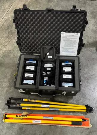 GPS/GNSS teaching kit available for loan (Emlid Reach RS2 receivers). Includes 1 base, 4 rovers, and associated survey poles/tripods for real-time kinematic GPS/GNSS surveys.
![[creative commons]](/images/creativecommons_16.png)
You can request the loan of several types of geophysics field instruments, including RTK-GPS/GNSS receivers, by completing the EarthScope Primary Instrument Center (EPIC) Experiment Schedule Requester.
THIS IS A NEW PROCESS FOR GETSI REQUESTS AS OF JANUARY 2024.
- Detailed guidance on making instrument requests is on the EarthScope Geophysics Field Education page.
- After you make an EPIC PI Account, access the Instrument Request Form.
Availability and timing — Many borrowers request the standard 5-receiver teaching kit (1 base, 4 rovers), although other configrations are available. Kits are available on a first-come-first-served basis. Typical loans are 3-4 weeks but we will do our best to work with the scheduling that will best serve your teaching goals.
Cost — There is no rental fee for the equipment, but there is a shipping/receiving charge of $225 for a 5-receiver kit and $125 for a 2-receiver kit (an invoice will be sent to your institution). Previously, shipping was the responsibility of the borrowing institution, but we found that our organization had considerably lower rates than most universities. The shipping/receiving fee was initiated to ensure the rates were lower and predictable. Some short-course participants may have been informed that the shipping for their first loan will be waived. If these shipping costs are prohibitive for your institution (ie., community colleges or other lower-resource institutions), please contact education_AT_earthscope.org to request a waiver. If your institution has lower shipping rates and you prefer to pay for shipping yourself, that is also fine.
Documentation for Emlid Reach GPS/GNSS receivers
Note: Emlid Reach RS2, RS2+, and RS3 have the same basic instructions. The primary difference is that RS2+ and RS3 can use 5G cellular for NTRIP corrections, whereas RS2 can only do 3G. Most geoscience users are not planning to use cellular corrections, so the difference does not matter. The RS3 has some additional capabilities, such as being able to take in corrections from a Trimble base station and having tilt compensation, but again, not critical to most geoscience educational use cases.
If your use case would benefit from NTRIP cellular corrections rather than a radio-based GPS/GNSS base station, you can refer to the NTRIP section of the Instructor Guide below and/or contact education@earthscope.org to discuss more about this with a staff member.
- Documentation and tutorials from Emlid
- Guides from GETSI
- Caring for and starting with Field Education Equipment (Microsoft Word 2007 (.docx) 137kB Apr19 23) PDF (Acrobat (PDF) 127kB Apr19 23)
- Instructor Guide for Emlid Reach RS2/2+/3 (Microsoft Word 2007 (.docx) 6.3MB Jun25 26) PDF (Acrobat (PDF) 2.4MB Jun25 26) — this includes background on the settings that the GETSI teaching kits come with and guidance on how to submit base station data to the NRCAN Precise Point Positioning (PPP) portal to determine an accurate base position.
- QuickStart Guide for the Emlid Reach RS2/2+/3 (Microsoft Word 2007 (.docx) 12.8MB Jun17 26) PDF (Acrobat (PDF) 4.6MB Aug8 25) — this guide is designed to be used in the field by students as a short and easy reference document.
Questions
Contact — education@earthscope.org