For the Instructor
These student materials complement the Coastal Processes, Hazards and Society Instructor Materials. If you would like your students to have access to the student materials, we suggest you either point them at the Student Version which omits the framing pages with information designed for faculty (and this box). Or you can download these pages in several formats that you can include in your course website or local Learning Managment System. Learn more about using, modifying, and sharing InTeGrate teaching materials.Capstone Project Stage 1
Course Capstone Project and Assessment: Coastal Vulnerability Audit
In order to assess your understanding of the diverse multi-disciplinary components of this course, Coastal Processes, Hazards, and Society, from the perspective of cutting-edge science, coastal engineering, risk assessment, public policy and environmental planning, as well as your attainment of the course goals, you will need to demonstrate mastery of key objectives. For this purpose, you will complete a Coastal Vulnerability Audit for a given site that will demonstrate mastery and an ability to apply key topics from every section and module of the course.
In order to complete the audit, you will use the Coastal Vulnerability Audit Tool (CVAT) which is developed as an outline to help aid you as you develop your capstone throughout the duration of the course. As you will see, each section of the CVAT is organized hierarchically to follow the content of the course. Each week, you should make additions to the audit tool so that you build your knowledge incrementally rather than waiting until the end of the semester to do all of it.
Regardless, you will need to select a specific location from a list of pre-approved cities, or gain permission of your instructor to choose another site. You will need to justify your choice of city to your instructor. In most courses, instructors will not want to have students choose the same cities, so choose a couple of back-up cities in case you do not get your first choice.
You will need to populate your CVAT with specific details and data from your independent research. It is a good idea for you to select a city or region that will provide you with online datasets and published literature, so some exploration is recommended before you settle on a specific location. Everyone will need to submit their request according to the instructor's expectations. Please note that when you select topics and locations for some of your assessments (i.e., locations for the summative assessment in Module 4: Tide Gauge Analysis), you should choose the city that you will focus your capstone on as one of your three required sites. This way, you will have already worked with specific dataset and you can directly integrate it into your final project. So, to repeat, as much as it is possible, we recommend that you integrate evidence of your research throughout the semester into your CVAT on an ongoing basis. We also suggest that you use online discussion activities so that you become proficient in the use of key terms and ideas and are able to accurately apply these concepts to your specific site. Specific details are below.
 Capstone Project: Stage 1: Figure 1: Credit Sean Cornell
The Assignment
You will ultimately create a "3 Minute" Audio-Annotated Google Earth Tour for one of the areas selected in the Module 4 summative assessment.
To this end in your "3 Minute Tour" you will need to:
- identify and describe a specific coastal setting (including physical and human landscapes), landforms, geomorphology, tectonic settings, processes etc. (Integrating Unit 1)
- explain the geologic context, hazards, and risks impacting the site, and the forecast for future hazards (Integrating Unit 2)
- outline efforts to assess vulnerability, plan for disaster management, and likelihood for mitigation/adaptation. (Integrating Unit 3)
- inform a resilience plan for future progress toward smart coastal planning and coastal resource management that highlights reduction of impacts to the environment, nature, society, and economies. (Integrating Unit 4)
Students must use the CVAT to help compile information to be integrated into your audio tour.
The Google Earth Tour MUST:
- include audio narration as you explanation your understanding of the chosen coastal setting from the perspective of geology, geomorphology, and human geography.
- be well written. Students will need to write and proofread their script in advance so their narration is of excellent quality, and so that it can be submitted for plagiarism detection.
- demonstrate application of major concepts (hazards, engineering applications, societal risk, etc.) from each module to the specific site.
- include at least 3 placemarks in the tour that highlight biologic or environmental impacts, economic impacts, social impacts, engineering, etc.) .
- Placemarks should include links to datasets available at NOAA, NASA, USGS, CENSUS, PSMSL, and other resources online to help illustrate and support major points raised in the discussion (YouTube videos, website content, etc.)
- contain 2 original graphics (Excel chart, GeoMapApp Visual, Annotated Maps, etc.) that communicate evidence of coastal hazards and forecasts for future sea level change, rates of shoreline erosion, etc.
- have at least two mitigation and adaptive planning measures that are recommended to minimize impact and help promote resilience to future coastal hazards.
- have citations to all sources of information used to support and develop the tour somewhere in the tour.
- be no more than 4 minutes in total duration.
What will you turn in?
- You will upload the completed tour as a KMZ/KML file to include all placemarks and the tour itself in a well-labeled folder. You have been provided with examples of KMZ files in the course in various modules, so you can use these as some examples.
- Typed script of the audio (to be run through the plagiarism detection).
- Any supporting documents that demonstrate your skills (i.e., Excel graphs, PowerPoint, copies of your completed audit tool, etc.).
Recommendations for Success
- Students might want to use free software like Camtasia or Snagit to record and produce their audio-annotated tour in a video format (.mp4 file, etc.) so that their submission is flawless and well-executed. Google Earth Tours can sometimes be "jumpy" when viewed on other computers due to factors out of your control.
- Students will want to show evidence that they practiced their delivery. Like a research paper, you will need to develop different drafts and edit them until you have a perfect final draft. It should be professional and very well done.

Instructions
This document contains 3 stages that are designed to follow the course content as it is developed so that you can complete the capstone audit of your selected city. Note that Stage 4 has three additional parts to help you prepare your final product. You will need to use this tool weekly to guide your data collection and organize your ideas and research information as you prepare your Google Earth Audio-Annotated Tour.
►Stage 1: Capstone Overview – Ready, Set, Go
Stage 2: Physical System Assessment
Stage 3: Human System & Engineering Infrastructure Assessment
Stage 4a: Vulnerability, Planning & Action
Stage 4b: Site Specific Concerns or Considerations
Stage 4c: Recommended Resiliency Action Plans
Stage 4d: References and Key Resources
Recommendations
- You will want to print this document out so that you have it in your class notes where it can be referred to and added to often.
- Each week, you should make notes on the pages where appropriate.
- On occasion, go back to the original electronic PPTx document to type up your notes.
- You are encouraged to add additional slides to the file to keep track of Excel Plots, Maps, etc.
- Using this tool as intended will put you on the right track to doing well with the capstone project.
- If you have questions, make sure you post your questions to the course discussion board (Yammer, etc.) or follow the recommendations of your instructor.
- DO NOT give one-word responses as you fill in the CVAT. You need to think deeply about each response and write responses that reflect that depth of thought as informed by your research.
Course Capstone Implementation Chart
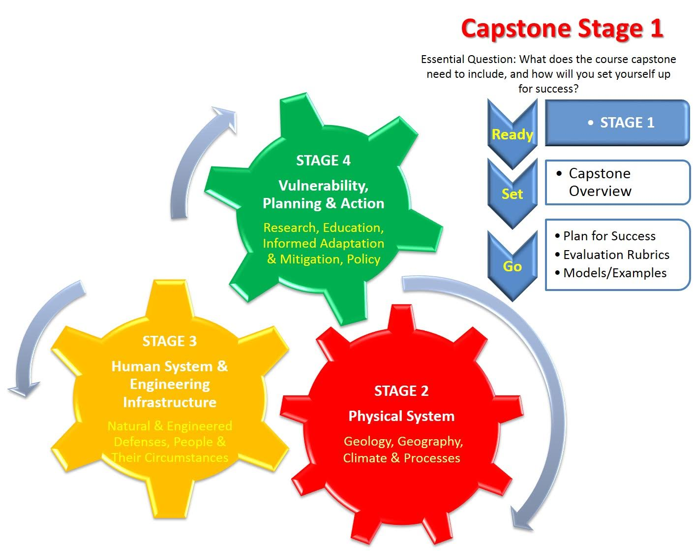
To help you remember the stages you will be passing through during the semester as you compile your capstone, you will want to study and refer to the following diagram:
 Capstone Project: Stage 1: Figure 2: Credit Sean Cornell
Supporting Documents: (Click to download)
- List of Pre-approved Cities (Acrobat (PDF) 28kB Sep7 16)
- Example of a Google Earth Video Tour
- Coastal Vulnerability Audit Tool (PowerPoint 2007 (.pptx) 562kB Sep7 16)
- Capstone Project Rubric (Acrobat (PDF) 83kB Sep7 16)