
For the Instructor
This material supports the Understanding Our Changing Climate GETSI Module. If you would like your students to have access to this material, we suggest you either point them at the Student Version which omits the framing pages with information designed for faculty (and this box). Or you can download these pages in several formats that you can include in your course website or local Learning Managment System. Learn more about using, modifying, and sharing GETSI teaching materials.Welcome Students!
-
Analyze geodetic data to assess ice sheet changes and the causes of observed sea level, and will make predictions of future sea-level rise.
- Assess the societal and economic consequences of observed and projected sea-level changes on regions most vulnerable to sea-level rise.
Unit 1: Climate Change and Sea Level: Who Are the Stakeholders?
 Flooded villages and fields around a river in Bangladesh the day after the 1991 Bangladesh cyclone had struck the country. In this unit, students will asses the potential societal impacts of sea level change, as shown in this image.
 ![[reuse info]](/images/information_16.png)
Depending on where you live, sea-level rise might not seem to affect your daily life. Yet it is important to think about how sea-level change is affecting different regions around the world. This unit contains case study examples for a coastal developing country (Bangladesh), a major coastal urban area (southern California), and an island nation (Maldives). What are the anticipated consequences of additional sea-level rise this century in these different places? In this module, you will consider the economic and social impacts of sea-level change. Your class will conduct a stakeholder analysis for one or more of the case study regions in order to better understand the effects of sea-level change.
- Pre-class readings: Your instructor will tell you which of the case studies to read.
- Low-lying, developing nation: Unit 1 Bangladesh Case Study Reading PDF (Acrobat (PDF) 3.1MB Nov12 19)
- Coastal urban area: Unit 1 Southern California Case Study Reading PDF (Acrobat (PDF) 1.9MB Nov12 19)
- Small island nation: Unit 1 Maldives Case Study Reading PDF (Acrobat (PDF) 6MB Nov12 19)
- Pre-class homework
- Unit 1 Student Pre-class Homework PDF (Acrobat (PDF) 329kB Nov12 19)
- In-class exercise
- Unit 1 Student In-Class Exercise PDF (Acrobat (PDF) 668kB Nov12 19)
Unit 2: Global Sea-Level Response to Temperature Changes: Temperature and Altimetry Data
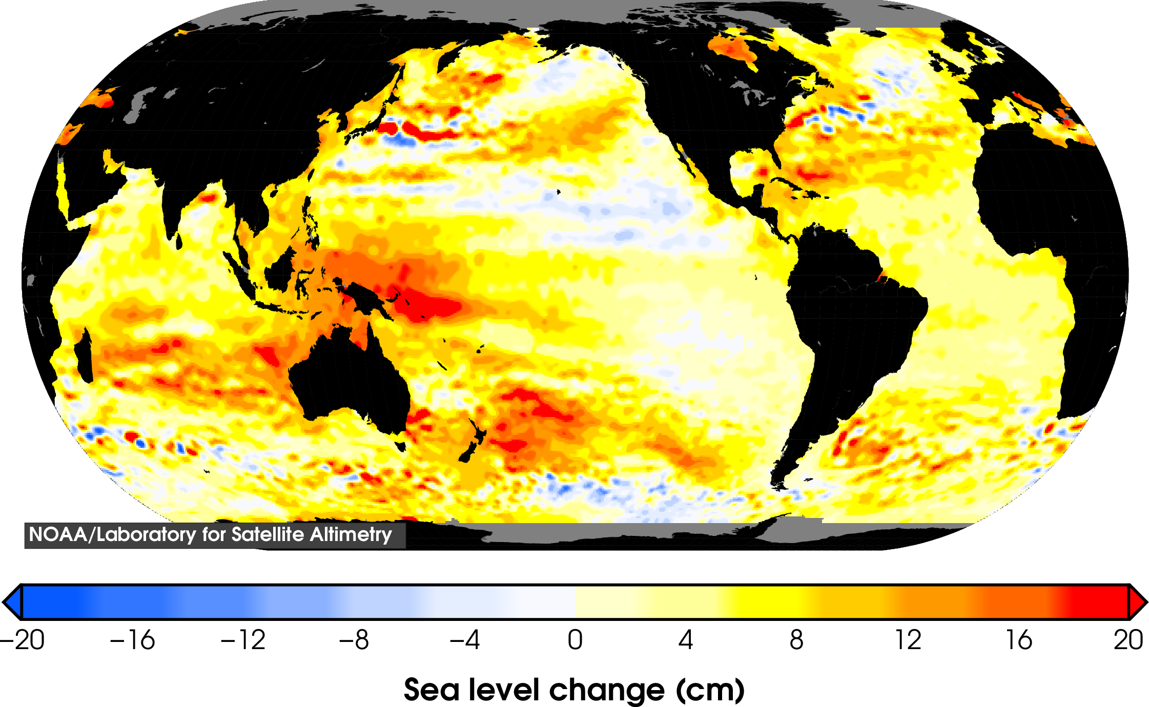
 Total sea level change since 1993. In this unit, students will asses the contribution of seawater thermal expansion to sea level rise, as shown in this image. Image from NOAA
![[creative commons]](/images/creativecommons_16.png)
You surely have heard of or studied global warming, yet how does this phenomenon affect changes in sea level? More specifically, what is the contribution of seawater thermal expansion to recent sea-level rise? In this unit, you will create time-series graphs of global averaged sea surface temperature anomaly (SSTA) data and assess the SST change during a given time period. Based on your calculated SST change, you will then calculate how much sea-level rise occurred due to thermal expansion of the oceans. You will then compare your calculated sea-level rise results to observed sea-level rise data from radar altimetry, and assess how much sea-level rise is attributable to thermal expansion.
- Unit 2 Student Exercise Sea Level and Temperature PDF (Acrobat (PDF) 223kB Jul15 24)
- Unit 2 Student Exercise Data File (Excel 2007 (.xlsx) 37kB Jul17 24)
- Unit 2 Assessment Rubric PDF (Acrobat (PDF) 65kB Nov12 19)
Unit 3: Global Sea-Level Response to Ice Mass Loss: GRACE and InSAR data
 Velocities of ice sheets over west Antarctica as determined by SAT data. In this unit, students will use SAT data to assess which regions of ice sheets are losing the greatest mass, as shown in this image. From NASA
Together, the Antarctic and Greenland ice sheets contain more than 99% of the freshwater ice on Earth. What is the contribution of their melting ice sheets compared to other sources of sea-level rise? In this unit you will use Gravity Recovery and Climate Experiment (GRACE) ice mass loss data from Greenland and Antarctica to calculate sea-level rise due to their melting ice sheets, and use Interferometric Synthetic Aperture Radar (InSAR) ice velocity data to extrapolate which regions of the ice sheets are losing the greatest mass. You will then compare sea-level rise from melting ice sheets to the other dominant causes of sea-level rise, including thermal expansion, melting glaciers, and changes in land water storage. Lastly, you will extrapolate how much sea-level rise will occur by year 2100 based on recent observed rates of sea-level rise, and compare these values to sea-level rise projections from the Intergovernmental Panel on Climate Change.
- Unit 3: Student Exercise Global Sea Level Response to Ice Mass Loss PDF (Acrobat (PDF) 2.8MB May21 21)
- Unit 3: Student Exercise Data File (Excel 2007 (.xlsx) 55kB Jul15 24)
- Unit 3: Student exercise assessment rubric PDF (Acrobat (PDF) 73kB Nov13 19)
Unit 4: Measuring Ice Mass Changes: Vertical Bedrock GPS
 KAGA station from the GNET GPS network showing the GPS antenna and solar panels. In this unit students will use position data from GPS stations like this one to monitor snow and ice loading/unloading. Photo by Bruce Douglas
Most likely you carry a GPS receiver (i.e., a smart phone) around with you, but how can GPS be used to measure changes in ice mass? GPS records of bedrock surface elevation are used to monitor snow and ice loading/unloading on decadal and annual time scales. In this unit, you will calculate trends in bedrock GPS data and then use the original records to identify sites in Greenland that exhibit similar behavior. You will gain experience with the challenges and benefits of using bedrock geodetic data to study snow and ice mass changes. You will also observe the post-glacial rebound that occurs in bedrock after the ice has melted away.
- Full version: Unit 4 Student Exercise PDF (Acrobat (PDF) 869kB Jul16 24)
Detrending Data Instruction Sheet_PDF (Acrobat (PDF) 1.8MB Nov3 20) - Shorter version: Unit 4 Student Exercise (no detrending) PDF (Acrobat (PDF) 867kB Jul16 24)
- Data
- Unit 4 Student Vertical GPS Data File (Excel 2007 (.xlsx) 1.8MB Jul26 24)
- Google Earth file of Greenland station locations (KMZ File 1kB Nov3 19)
- Unit 4 Student Exercise Rubric PDF (Acrobat (PDF) 54kB Dec8 19)
Unit 5: Societal Implications of Climate Change: Stakeholder Report
 Flooding in New Orleans from Hurricane Katrina. In this unit students will asses the potential societal and economic consequences of sea level rise, as shown in this image. From Wikipedia
You have learned by now that sea-level rise due to the melting of glaciers and ice sheets and ocean thermal expansion has significant societal and economic consequences. In this final unit, you will prepare a summary of the impacts of sea-level rise for relevant stakeholders by tying together all of your obtained knowledge and analyses from the previous units. You will integrate the stakeholder analysis in Unit 1 with the geodetic data (radar satellite altimetry, GRACE, InSAR, and GPS) of ice mass loss and sea-level rise from Units 2–4 in your analysis.
- Student Unit 5 Instructions for Stakeholder Report and Rubric PDF (Acrobat (PDF) 422kB Dec19 19)
- Reflection Statement Instructions and Rubric PDF (Acrobat (PDF) 199kB Dec19 19)
- Support for report writing
- How To Organize a Scientific Paper (Microsoft Word 55kB Nov11 19)
- How To Organize a Paragraph (Microsoft Word 46kB Nov11 19)
- A Simple Approach to Improve Student Writing (Acrobat (PDF) 158kB Jun23 05)


