Part 1—Examine Maps Created by the Voyager Map Tool
Step 1 – Go to the Voyager Homepage
Begin at the ['Jules Verne Voyager Homepage' new]. The homepage will open in a new window.
The Jules Verne Voyager map tool is named in honor of the visionary author, Jules Verne, who wrote about space, air, and underwater travel long before they were technologically possible.
The image on the Jules Verne Voyager homepage shows a random sample of one of the datasets available for mapping.
- Click your browser's Refresh or Reload button a few times to see some of the datasets that are available.
Step 2 – View Example Maps in the Image Gallery
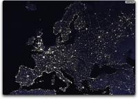
 Europe by Night, DMSP imagery. Click the image for a larger view. source: Jules Verne Voyager Gallery
 To view more detailed map images created with Voyager, click the Image Gallery link below the image on the Jules Verne Voyager homepage. Be aware that Voyager opens new windows for most of its different features.
- Click any of the thumbnail images in the Image Gallery for a full-size view and description of the map.
- Notice that Voyager creates flat map images as well images of planets as viewed from space. You can also make simpler maps that show features like political boundaries, country names, and city locations.
- Keep in mind that with the global-scale data available in the tool, small details like those you might see in a city map will not be shown. Rather, the data are well suited for showing relatively large areas.
- Close the Image Gallery window, and click back to return to the [Jules Verne Voyager Homepage' new].


