How Do I Calculate Channel Slope/Gradient?
In geometry class, we learn that the slope of a line is calculated by dividing the vertical change (rise) by the horizontal change (run). On a piece of graph paper, that's pretty straightforward. But how does that work when we're looking at a river or stream in the real world?
Why Does Channel Slope Matter?
Channel slope is a key metric for understanding whether a river is eroding or depositing sediment. A steep slope means that water is moving faster, which can mobilize larger particles of sediment. In contrast, a shallower slope means the current doesn't have enough energy to keep those larger grains suspended and they deposit on the river bed. In the absence of disturbance, most rivers move towards a slope that allows for a dynamic equilibrium between erosion and deposition.
How Do I Calculate Channel Slope in the Geosciences?
Maximum Channel Slope
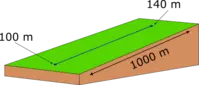 Fig. 1: In this idealized situation, the channel is perfectly straight.
- First, we need to know "rise" for the feature. Rise is the difference in elevation from the top to bottom of the feature we're interested in.
- For the "run", simply measure the straight line distance between the two points. In Fig. 1, the "run" distance is labeled as 1000 m.
- Take the difference in elevation and divide it by the horizontal difference (always making sure you keep track of units).
- You can also express the gradient as a percent, as long as the rise and run are both in the same units.
Meandering Channel Slope
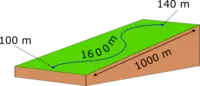 Fig. 2: In this example, the channel is meandering across the landscape.
- In Fig. 2, the rise is the same as it was in Fig. 1. The elevation is 140 m at the top and 100 m at the bottom. So the "rise" = 40 m.
- In this case, we need to measure the length of the stream channel, rather than the straight line distance from the top to the bottom. Measure along the path of the stream to get this distance. In Fig. 2, the channel length is labeled as 1600 m.
- Take the difference in elevation and divide it by the horizontal difference (always making sure you keep track of units).
- You can also express the gradient as a percent, as long as the rise and run are both in the same units.
Channel Slope from a Topographic Map
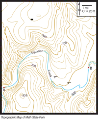 Fig. 3: This simplified topographic map shows a creek flowing through a fictional state park.
- First get comfortable with the features of the topographic map in Fig. 3. Make sure you know a few things:
- What is the contour interval (sometimes abbreviated CI) of this map?
The contour interval tells you "rise," specifically the change in elevation between each of the contours (the brown lines). In this case, the contour interval is shown in the key in the upper right and is 20 ft. - What is the scale of the map?
The scale tells you the "run," or the distance on the ground. On this map, it is also shown graphically in the key. If you print out the map (Acrobat (PDF) 336kB Apr2 26), you will find that the scale is 0.75 inch = 1 mile. - What is the feature for which you want to know the slope?
We want to find the channel slope between points A and B on the map.
- What is the contour interval (sometimes abbreviated CI) of this map?
- Next we'll use the contour lines on the map to figure out the "rise" between the two points. A is at the point where the 680 ft contour crosses the creek. B is where the 580 ft contour crosses the creek. That means that the difference in elevation is
`text{rise}=680\ ft\-\580\ ft=100\ ft` - In this example, the "run" is the distance along the course of the creek between A and B. Use a flexible measuring tape or piece of string to find out how long the channel is between the points. Then use the scale bar to convert that length into a distance. The length on the map should come out to be about 10.5 inches. Using the scale bar, that means that the channel's run = 14 miles.
- Now comes the "rise over run" part. There are two ways that you may be asked to make calculations relating to slope. Make sure you know what the question is asking you and follow the steps associated with the appropriate process:
- If you are asked to calculate slope (as in a line or a hillside), a simple division is all that is needed. Just make sure that you keep track of units!
- You may also be asked to calculate percent (or %) slope. This calculation takes a couple of steps. And it mostly has to do with paying attention to units. The units on both rise and run have to be the same.