Initial Publication Date: June 17, 2005
- First Publication: June 17, 2005
- First Publication: June 17, 2005
|
Cite thisA Traverse Across the Northern Belt Basin From East Glacier Park, Montana to Bonners Ferry, Idaho
Route
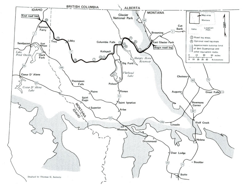
Start point
East Glacier Park, Montana at intersection of U.S. 2 and Montana 49
End point
Bonners Ferry, Idaho
Roads
U.S. 2, Hungry Horse Dam Road, U.S. 95
Total distance
225.1 miles
Geology
Summary
This field guide examines differences between three segments of the Belt Basin along an east-west transect along Montana 2 from East Glacier Park, Montana to Bonners Ferry, Idaho. Each segment is characterized not only by its structural style, but also by the suite of Belt rocks that comprise it. The easternmost segment consists of the Lewis thrust plate and associated thrusts as far west as Columbia Falls, Montana where it is terminated by the Rocky Mountain trench. This segment contains eastern Belt facies including: Altyn, Appekunny, Grinnell and Helena (Siyeh), Snowslip, Shepard, Mount Shields and McNamara formations. Fine sediments in these rocks, probably derived from a western continental source terrane, were deposited adjacent to the stable North American craton, where they were mixed with smaller amounts of coarse sand derived from an inferred coarse sand sheet that mantled the crystalline craton. The central segment extends from the Rocky Mountain trench to the Libby thrust system. It is characterized by broad, open folds that expose Belt rocks of the central part of the basin, including a thick section of Prichard, Burke, Revett, St. Regis, Empire, Wallace and Helena formations. These rocks are composed mostly of argillite, carbonate and fine-grained quartzite. The western segment includes the Libby thrust and Leonia fault system. It extends as far west as the Purcell trench. Exposed in this area are rocks from the Prichard through the Missoula Group. Rocks of the Ravalli Group and the Wallace Formation contain more fine-to medium-grained quartzite than those of the central segment, reflecting a western source. However, the Missoula Group rocks are finer grained and more calcareous than those of the type area, indicating that late in the Middle Proterozoic the western source terrane probably subsided and that the basin center shifted westward.
Key Lithologic Features
- Proterozoic sedimentary rocks of the Belt Supergroup
- Altyn Formation
- Appekunny Formation
- Bonner Formation
- Missoula Group
- Helena Formation (with stromatolite fossils and carbonate cycles)
-
- Snowslip Formation (with stromatolite fossils)
- Mount Shields Formation (with stromatolite fossils)
- Grinnell Formation
- Ravalli Group
- Shepard Formation
- McNamara Formation
- Empire Formation
- Spokane Formation
- Burke Formation
- Wallace Formation
- Garnet Range Formation
- Libby Formation
- Prichard Formation
- Late Proterozoic igneous rocks
- Crossport sill (and related sills)
- Paleozoic sedimentary rocks
- Silver Hill Formation (Cambrian)
- Mesozoic sedimentary and volcanic rocks
- sandstones and shales of the Marias River Formation (Cretaceous)
- sandstones and shales of the Blackleaf Formation (Cretaceous)
- sandstones and shales of the Kootenai Formation (Cretaceous)
- Ellis Group (Jurassic)
- Tertiary deposits
- gravels of the Kishenehn Formation
- Quaternary deposits
- boulder terrace gravels of Bear Creek
- deposits of Glacial Lake Kootenai
Structures
- Lewis thrust fault
- unnamed anticline in Jurassic Ellis Group sedimentary rocks
- Blacktail fault
- angular unconformity between tilted Tertiary Kishenehn gravel and overlying boulder terrace gravel
- Nyack fault
- sedimentary structures in Belt Supergroup rocks
- folds and thrusts of Belt Supergroup sediments at Badrock Canyon
- Pinkham thrust fault
- Purcell anticline
- Libby syncline
- Leonia thrust fault
Landforms
- Marias Pass (Continental Divide)
- Geifer Creek valley
- Snowslip Mountain
- Mount Shields
- Flathead River valley
- Teakettle Mountain
- Badrock Canyon
- Rocky Mountain trench
- glacial moraines and potholes
- Salish Mountains
- Kootenai Falls
- Moyie River Gorge
Other Features
- southern Glacier National Park
Reference
Winston, D., Woods, M., 1986, Road Log No. 3, A Traverse Across the Northern Belt Basin From East Glacier Park, Montana to Bonners Ferry, Idaho,
in Roberts, S.M., ed.,
Belt Supergroup: A Guide to Proterozoic Rocks of Western Montana and Adjacent Areas , Montana Bureau of Mines and Geology Special Publication 94, p. 47-68.
Availability
Out of print; can be photocopied for a fee. For more information, see this publication's record at the
MBMG .