Initial Publication Date: June 17, 2005
- First Publication: June 17, 2005
- First Publication: June 17, 2005
|
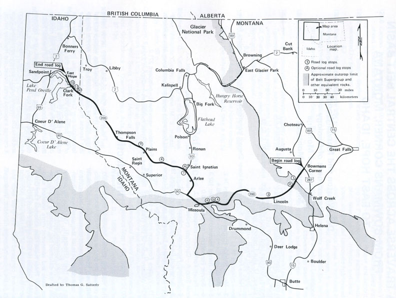
Cite thisA Traverse Across the Central Belt Basin From Bowmans Corner, Montana to East Hope, Idaho
Route
Start point
Bowmans Corner, MT; junction of U.S. 287 and Montana 200
End point
East Hope, Idaho
Roads
Montana 200, I-90, U.S. 93
Total distance
281.2 miles
Geology
Summary
This road log highlights a variety of sedimentary rock types and structures along a transect of the Rocky Mountain Fold and Thrust Belt. The log follows Montana Highway 200, which crosses the central part of the Middle Proterozoic Belt basin from the Montana disturbed belt to Missoula, where it turns northwesterly into northern Idaho, traversing rocks of the western and northwestern Belt basin. The road log begins east of the Rocky Mountain front in the disturbed belt underlain by soft, Cretaceous shale and somewhat more resistant sandstone units. Next, the road log passes into the eastern thrust belt where thrust faults bring Belt rocks first over Cretaceous, then over Paleozoic rocks, and finally over Proterozoic rocks farther to the west. At Rogers Pass, the route crosses the Continental Divide and into the Ovando block where Cenozoic listric normal faults form the major structures. The leading edge of the western thrust belt is encountered at Bonner, MT. From Missoula, Highway 200 trends northwestward to northern Idaho and diagonally crosses the western part of the Belt basin. Changes in grain-size and sediment type observable from outcrops along this road log illustrate the evolution of sedimentary transport and facies tracts within the central part of the Belt basin.
Key Lithologic Features
- Proterozoic sedimentary rocks of the Belt Supergroup
- Greyson Formation
- Spokane Formation
- Empire Formation
- Helena Formation (includes terrigenous-to-carbonate cycles)
- Shepard Formation (includes stromatolite beds)
- Mount Shields Formation (includes sedimentary structures)
- Bonner Formation (includes outstanding cross-bedding
- Pilcher Quartzite
- McNamara Formation
- Garnet Range Formation (includes cross-bedding
- Revett Formation
- Prichard Formation (siltstones and mudstones)
- Burke Formation (argillites and quartzites)
- Wallace Formation (with stromatolites)
- St. Regis Formation
- Snowslip Formation
- Missoula Group
- Libby Formation (with stromatolites)
- Late Proterozoic igneous rocks
- metadiorite sill intruding the Empire Formation
- diabase sill in Prichard Formation
- Paleozoic sedimentary rocks
- Flathead Sandstone (Cambrian)
- Mesozoic sedimentary and volcanic rocks
- various Cretaceous formations containing sandstones, siltstones, mudstones, shales, and interbedded volcanic ash-flow tuffs and latite flows
- Tertiary deposits
- tuffaceous volcanic sediments
- Quaternary deposits
- Blackfoot glacial moraine
- Monture Creek terminal moraine
- glacial outwash plain and terminal moraines of the Swan Valley glacier
- varved lacustrine silt and clay of Glacial Lake Missoula
- glacial deposits associated with the Jocko Valley glacier
Structures
- Steinbach thrust fault
- Eldorado thrust fault
- Hoadley thrust fault
- Wishard Creek syncline
- St. Mary's fault
- Big Hole Peak Syncline
- Hope fault
Landforms
- Rogers Pass (Continental Divide)
- Ovando Valley
- Potomac Valley
- Missoula Valley
- river terraces of the Clark Fork River in Missoula
- Mission Range
- Ravalli hill
- Clark Fork River Valley
- Thompson River Valley
Other Features
- stromatolite fossil localities in the Belt Supergroup
Reference
Winston, D., and Woods, M., 1986, Road Log No. 2, A Traverse Across the Central Belt Basin From Bowmans Corner, Montana to East Hope, Idaho,
in Roberts, S.M., ed.,
Belt Supergroup: A Guide to Proterozoic Rocks of Western Montana and Adjacent Areas , Montana Bureau of Mines and Geology Special Publication 94, p. 17-45.
Availability
Out of print; can be photocopied for a fee. For more information, see this publication's record at the
MBMG .