Study questions
The following study questions are arranged in chronological order. Use the slider and pause button on the NAVDAT animation to examine in more detail the volcanic activity which occurred during the time periods listed below. If you prefer a printout of the full set of study questions, choose Print from the File menu.
65-25 Ma
- During this period, what type of plate boundary was located along the western margin of North America? Which plates were in contact at this boundary, and in what direction was the subducting plate moving relative to the upper plate? (to answer these questions, see Tanya Atwater's animation)
- In your introductory geology course, you learned that a common feature found on the upper plate of a subduction zone is a linear chain of volcanoes located close to the plate margin (and oriented parallel to it) called the volcanic arc. Good examples of continental margin volcanic arcs which are presently-active include the central Andes, western Central America, and the Cascade Range in the Northwest United States and neighboring Canada. Does the distribution of volcanoes in western North America from 65-25 Ma look like the volcanic arc shown in the diagram above? Why or why not?Continental-margin subduction zone
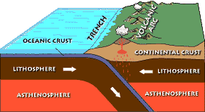
Image courtesy of the USGS.
- One theory for the volcanic activity during this period is that it was somehow related to the subduction of the Farallon slab, a process some geologists think was the cause of the Laramide Orogeny which occurred between 70-20 Ma and resulted in the uplift of the Rocky Mountains. Let's assume this theory is correct for the rest of this question. Melting above subducted slabs usually takes place when the slab is at a specific depth (~120 km). If the magmatism in the western U.S. was produced in this manner, what must have been different about the geometry of the subducted slab during this time as compared to when it was underlying the Sierra Nevada batholith in central California ~100 million years ago?
40-25 Ma
- Describe the change in volcanic activity that began at 40 Ma and continued for the next 15-20 million years. What was the dominant composition of the materials erupted? Where were the main concentrations of this activity centered?
- You have just identified the very interesting and enigmatic period of volcanism that is known as the Mid-Tertiary Ignimbrite Flare-up. Repeatedly advance the slider bar so you can watch the volcanic activity during this time period. Are there any time-space migrations in magmatism of the main concentrations you identified earlier? If so, describe them.An ignimbrite in the process of forming during a pyroclastic eruption

Photo courtesy of the USGS. - The cause of the Mid-Tertiary Ignimbrite Flare-up has been a great mystery to geologists and continues to be hotly debated. Given the geometry of the Farallon subduction zone during this time, do the migrations of activity you identified above seem to be readily explained by a changing geometry of subduction similar to that identified in #3 above?
- Finally, do you see any relationship between the location of the Ignimbrite Flare-up (during its entire duration) and the boundaries of any of the geologic provinces of the United States? When did this province become tectonically-active? Suggest a possible explanation for the different timing of these two events.
25-17 Ma
- Describe what happened to the Farallon subduction zone during this time period (see Atwater's animation). What tectonic feature represented by the solid purple line was produced as a result?
- Many geologists believe that the initiation of the tectonic feature you identified in #8 had important effects on volcanic activity in the southwest U.S. While this idea is a controversial one, it can, in principle, be tested with a regional database like NAVDAT. From your brief observations of the animation at least, does there seem to be any immediate (25-18 Ma) and obvious response in the southwestern U.S. to this change in plate boundary?
17-0 Ma
- Notice the sudden burst of volcanic activity centered in northernmost Nevada at 17-16 Ma. Focus on the yellow dots associated with this burst of activity indicating voluminous rhyolitic volcanism; advance the slider bar to follow the migration of felsic magmatism from 17 Ma to the present. Which direction(s) does it go? Where is this felsic volcanism located at present? Most geologists believe this migration is evidence for motion of the North American Plate above a mantle hotspot (perhaps even a plume). Do your observations support this theory as an explanation of all of the migrations you observed?
- Locate the general area of the Columbia Plateau on the NAVDAT animation. This geologic province was the site of one of the world's largest outpourings of lava. Using the NAVDAT animation, what was the composition of this lava (don't be confused by the overlapping pattern of arc volcanism in the Cascade chain), and when was it volcanically active?Lava flow, Columbia Plateau

Photo courtesy of D.P. Schwert, North Dakota State University. - What is the general trend in magma composition for the entire western U.S. during the last 15 million years?
Additional questions
- The Cascade volcanic arc has been active for the past 36 million years. In your introductory geology class, you learned that subduction volcanism was dominated by intermediate (andesitic) magma compositions. From the NAVDAT animations, is andesite the only type of magma produced at subduction zones?
- Locate the general area of the Colorado Plateau on the NAVDAT animation. How has this region differed from surrounding regions in terms of volcanic activity during the last 65 million years? How has the southern margin of the Colorado Plateau (defined by the northernmost extent of volcanism in the Arizona Basin and Range and the westernmost volcanism in the Rio Grande Rift in central New Mexico) changed over the last 20 million years?
- Earlier in the exercise, you identified a migration of rhyolitic volcanism eastward through the Snake River Plain in southern Idaho. Does basaltic volcanism follow this trend, or does it persist well after the felsic migration has passed through? What might be a possible explanation for what you observe?