Teaching Notes
Example Output
Note: This chapter was retired in October 2018. The visualization tool (My World GIS) is no longer supported.
This close-up image shows velocities along the Mid-Atlantic Ridge between South America and Africa.
This image shows a sample output from My World GIS for this chapter. Click the thumbnail for a larger view.
Grade Level
High school (upper-class, level 11-12) or undergraduate Earth Science college course.
Learning Goals
After completing this chapter, students will be able to:
- Download geospatial data for GIS analyses;
- Map, graph, and analyze geospatial information; and
- Interpret the results of GIS analyses to understand the relationship between earthquake locations, plate boundaries, and seismic waves.
Background Information
Prerequisite knowledge:
- Students completing this chapter should have already explored and understand the relationship between tectonic plate boundaries and earthquake epicenters.
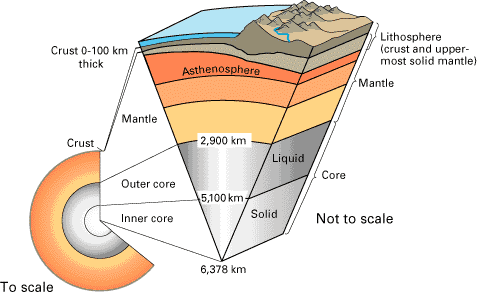
- The Earth's Interior
Three main layers: Crust, Mantle, and Core.
Inside the Earth from USGS
Earth is made up of three main layers: the crust, mantle, and core. The rigid crust, which consists of continental and oceanic material, varies in thickness from 5 km under the oceans to approximately 50 km under the continents. The crust can reach thicknesses of 70 to 100 km under major mountain ranges such as the Alps and Himalayas. Beneath the crust, the denser and hotter mantle is a semi-solid material approximately 3000 km thick. The Earth's core, which is denser than the overlying mantle, consists of a liquid outer core and solid inner core.
- Tectonic Plate Boundaries
Four types of plate boundaries are recognized by the U.S. Geological Survey (USGS): Divergent, Convergent, Transform, and Plate-boundary zones. The new designation of plate-boundary zone identifies areas that are not well defined and the effects of plate interaction remain unclear.
Understanding Plate Motions from USGS
The USGS Plate Boundary Diagram website has useful information on the types of plate boundaries and what they look like when viewed from the side (in a cross section).
- Detecting Layer Changes Using Secondary or Shear Wave Velocities
The transition from crust to mantle can be detected by an increase in secondary (shear) wave velocities.
We can detect the transition from crust to mantle by an increase in shear wave velocities: the waves move faster as they enter the denser material of the upper mantle. The map below shows shear wave velocities at a depth of 28 km below Earth's surface. This depth is below the oceanic crust and at the lower edge of much of the continental crust. The shear wave velocities in the continental crust (< 4.0 km/sec) are shown in brown and are slower than those in the upper mantle. The velocities in the upper mantle are shown in blue and orange; those in the orange areas are slower (4-4.6 km/sec) than those in the blue areas (4.6-5.0 km/sec).
- Changes In Shear Wave Velocities With Depth
Velocity Changes Based on Composition, Temperature, and Pressure.
The difference in shear wave velocities between and within layers is based on the composition, temperature, and pressure of the material through which the waves are passing. The map below shows shear wave velocities at a depth of 100 km below Earth's surface (in the mantle). The areas in orange are relatively hotter and less dense than those in blue. Shear waves moving through the orange areas have slower velocities (4-4.6 km/sec) than those in blue (4.6-5.0 km/sec). Plate boundaries, shown in light blue, are strongly correlated with slower shear wave velocities. These are areas where the mantle is hotter and less dense.
Instructional Strategies
Examples of datasets that can be investigated with the techniques of this chapter include: earthquake activity; watersheds, elevation and bathymetry; global land and sea surface temperatures. Any other datasets with latitude and longitude coordinates, such as those gathered with a GPS, could be analyzed in a GIS.
Learning Contexts
In the context of plate tectonics, this chapter explores the relationships among a seismic shear wave velocity model, earthquake epicenters, and tectonic plate boundaries. Although it deals with how a solid Earth dataset can be used within a geographic information system (GIS), many of the chapter's procedures can be applied to other datasets.
The primary goal of this chapter is to graph the changes in seismic shear wave velocities across the North American continent. The relative changes in wave velocity indicate density differences between Earth's crust and upper mantle.
This chapter can be used in conjunction with other plate tectonic investigations included in the Earth Exploration Toolbook.
Science Standards
The following National Science Education Standards are supported by this chapter:
Grades 9-12
- Use technology and mathematics to improve investigations and communications.
A variety of technologies, such as hand tools, measuring instruments, and calculators, should be an integral component of scientific investigations. The use of computers for the collection, analysis, and display of data is also a part of this standard. Mathematics plays an essential role in all aspects of an inquiry. For example, measurement is used for posing questions, formulas are used for developing explanations, and charts and graphs are used for communicating results.
- Formulate and revise scientific explanations and models using logic and evidence.
Student inquiries should culminate in formulating an explanation or model. Models should be physical, conceptual, and mathematical. In the process of answering the questions, the students should engage in discussions and arguments that result in the revision of their explanations. These discussions should be based on scientific knowledge, the use of logic, and evidence from their investigation.
- Natural and human induced hazards present the need for humans to assess potential danger and risk.
Many changes in the environment designed by humans bring benefits to society, as well as cause risks. Students should understand the costs and tradeoffs of various hazards - ranging from those with minor risk to a few people to major catastrophes with major risk to many people. The scale of events and the accuracy with which scientists and engineers can (and cannot) predict events are important considerations.
Geography Standards
The following U.S. National Geography Standards are supported by this chapter:
- How to use maps and other geographic representations, tools, and technologies to acquire, process, and report information from a spatial perspective
- How to analyze the spatial organization of people, places, and environments on earth's surface
Time Required
Four 45-minute class periods
Other Resources
Teaching Resources
Completed files for this chapter can be downloaded from the links below. These files can be used as teaching resources or as a way of checking student work.
Right-click to save these files to your desktop. They do not need to be un-zipped before using in My World.
Funding for this chapter was provided by the Geosciences Cyberinfrastructure Network
(GEON) project which is creating a cyberinfrastructure for the geosciences. This material is based upon work supported by the National Science Foundation under Grant No. 225673 (GEON). Any opinions, findings, and conclusions or recommendations expressed in this material are those of the author(s) or originators and do not necessarily reflect the views of the National Science Foundation.