
Landslide susceptibility in cuesta scarps of SW-Germany (Swabian Alb)
Shortcut URL: https://serc.carleton.edu/31993
Location
Continent: Europe
Country: Germany
State/Province:Baden-Wuerttemberg
City/Town:
UTM coordinates and datum: none
Setting
Climate Setting: Humid
Tectonic setting:
Type: Process


Description
Keywords. GIS-based hazard modelling, slope stability, Hirschkopf landslide, landscape evolution, natural hazards.
Damage to settlements and infrastructure as well as human casualties caused by landslides are increasing worldwide (Singhroy et al., 2004). In the low mountain areas of Central Europe the expansion of urban and industrial areas into landslide prone terrain increases the potential for slope instability (Damm and Terhorst, 2009; Terlien et al., 1995).
In the context of climate change coupled with increasing precipitation rates regionally, investigations of natural hazards in the temperate zone are becoming more pronounced in scientific and public interest.
To predict future developments, and to compile susceptibility maps, it is essential to know about past processes. Ancient landslides essentially contribute to landscape evolution and therefore, the retrospective analysis on the base of detailed field survey is a key to improve the quality of GIS studies (Brunsden and Lee, 2004).
The study area is located at the steep cuesta scarp of the Jurassic escarpment of the Swabian Alb (SW-Germany, Fig. 1), which has been studied for many years (e.g. Bibus, 1986; Terhorst, 2001). During recent and historic times, large and small landslides have periodically occurred at the steep slopes of the cuesta scarp. The occurrence of the landslides is linked to a combination of causative factors, reflecting general natural settings in the study area. Primarily, the Swabian Jurassic escarpment, which rises 300–400 m over its foreland, is characterised by very steep slopes, providing high potential energy for landslides. Furthermore, geological conditions, namely alternation between permeable and impermeable Jurassic rocks, are most important for slope instability. The plasticity of the Middle Jurassic clay (Callovian) and, in particular, the boundary between this clay and the overlying Oxford marls (ox1) is conducive to landslides (Fig. 2). The impermeable Callovian clays perch water and form the main spring horizon in the cuesta slopes. As a consequence, the Oxford marls moisten and the enhanced pore water pressure softens the marl layers.
The main type of mass movement can be described as slump-earth flow (Fleming and Varnes, 1991), a combination of sliding and flowing movements (Fig. 2). Typical geomorphological phenomena of the slopes are rotational sliding blocks with an average length between 200–300 m and a width between 20–50 m. Field studies show that this type of slide mass forms large parts of the cuesta scarp. Inside the mass wasting deposits, small translational slides and flows are present (Terhorst, 2001).
Stratigraphical investigations show that large rotational landslides occurred during the Pleistocene period, whereas during the Holocene period, only older mass wasting deposits were reworked and displaced by translational slides and flows (Terhorst, 2007). Pleistocene slides are combined mass movements, as slump-earth flows forming rotational blocks. The displaced material consists of Oxford limestones and Oxford marls. Extensive semi-circular main scarps on the upper slopes of the Jurassic scarp, marginal depressions on the block surfaces and the tongue-like foot of the landslides, are some of the typical features (Fig. 2).
During the Holocene period, secondary landslides with high recurrence frequency and limited extent have reworked the palaeo-landslides. This happens at specific vulnerable spots within the Pleistocene landslide areas and is controlled by hydrology and therefore by precipitation rates (see Kraut, 1999). Due to these processes, the stability of the rotational block decreases successively. Even the slightest movement in the rotational blocks can reactivate the Pleistocene slide masses and lead to catastrophic results. The best-known example for a catastrophic event is the Hirschkopf Landslide in 1983 (Fig. 3), where a minor block displacement led to massive movement of detritus and bedrock on the upper slope and devastating flow processes and destruction on the lower slope (Bibus, 1986). Thus, the Holocene period must be regarded as the preparatory phase for the development of new and larger rotational movements.
In general, broad areas of the Swabian Alb cuesta scarp must be classified as potential risk areas for mass movements (Neuhäuser and Terhorst, 2007). According to Kallinich (1999) up to 20 % of the slope areas of the W Swabian Alb cuesta scarp are moving actively. Of major importance is the fact that ca. 90% of the recent slope movements are coupled to Pleistocene slide masses (Bibus and Terhorst, 2001).
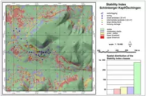
A combination of field data, a comprehensive database on landslides (Kraut, 1999), and statistical analyses forms the base for the compilation of GIS-based landslide susceptibility maps using different methods. Thein (2000) created susceptibility maps on the base of logistic regression. Kreja and Terhorst (2005) generated a landslide susceptibility map for a residential area with house damages based on the Open Source GIS 'SINMAP' (Stability Index Mapping) published by Tarboton (1997) and Goodwin et al. (1999) (Fig. 4). This assessment approach requires detailed hydrological data and high-resolution digital terrain models (minimum resolution 10 m) and therefore, is applied to small areas. For example, the map shows that recently affected positions are directly linked to older slide masses and that the house damages belong to the stability index of "lower threshold" (Fig. 4).
Neuhäuser and Terhorst (2007) applied the 'weights-of-evidence-method' to produce a susceptibility map for a large area of the cuesta scarp (Fig. 5). The method was originally developed for mineral exploration (Bonham-Carter, 2002). The main objective was to quantify the susceptibility to landslides, to identify and rank the preparatory (causative) sliding factors.
During the last decades, damages due to mass movements have been consistently occurring in the study area. Although large mass displacements like in the Moessingen landslide of 1983 are rare, catastrophic events are in the realm of possibility. In general, the occurrence of recent landslides is closely linked to palaeo-landslides and this fact form an important basis for the development of risk models and the compilation of planning maps for the cuesta scarp.
Through an integrative approach the maximum data available for the study area was compiled in order to create susceptibility maps for landslide hazard. Several modelling approaches showed that the evalutation of maps and archives only has not proved satisfactory. Implication of geomorphological field analyses and landscape evolution lead to more differentiated results in hazard modelling.
Download SINMAP here: http://hydrology.neng.usu.edu/sinmap/getinfo.html
Associated References
Bibus, E., 1986. Die Rutschung am Hirschkopf bei Mössingen. Geoökodynamik 7, p. 333- 360.
Bibus, E. and Terhorst, B., 2001. Mass movements in South-West Germany. Analyses and results from the TübingenWork Group of the MABIS Project. Zeitschrift für Geomorphologie N.F. Suppl.-Bd. 125, p. 53-63.
Brunsden, D. and Lee, E. M., 2004. Behaviour of Coastal Landslide Systems: an Inter-disciplinary View. Zeitschrift für Geomorphologie N.F. 134, p. 1-112.
Damm, B. and Terhorst, B., 2009. A model of slope formation related to landslide acitivity in the eastern Pre-Alpes, Austria. In: Terhorst, B., Solleiro-Rebolledo, E. and Veit, H. (eds.), Reconstructing and Modelling Quaternary Landscapes, Geomorphology special issue, accepted.
Fleming, R. W., Varnes, D. J., 1991. Slope movements. In: Kiersch, G. A. (Ed.), The heritage of engineering geology. Geolog. Soc. of America, Centennial special vol. 3, pp. 201-218.
Goodwin, C. G., Pack, R. T., Tarboton, D. G., 1999. SINMAP – A stability index approach to terrain stability hazard mapping. SZ Terratech Consulting Ltd.Salmon Arm, B.C., Canada.
Kallinich, J., 1999. Verbreitung, Alter und geomorphologische Ursachen von Massenverlagerungen an der Schwäbischen Alb auf der Grundlage von Detail- und Übersichtskartierungen. Tübinger Geowissenschaftliche Arbeiten D4, 166 p.
Kraut, C., 1999. Der Einfluss verschiedener Geofaktoren auf die Rutschempfindlichkeit an der Schichtstufe der Schwäbischen Alb. Tübinger Geowissenschaftliche Arbeiten D5, p. 129-148.
Kreja, R. and Terhorst, B., 2005. Naturgefahren in einem Baugebiet bei Öschingen an der Schwäbischen Alb: GIS-gestützte Ermittlung rutschungsgefährdeter Gebiete am Schönberger Kapf bei Öschingen. Die Erde 136/4, p. 397-414.
Neuhäuser, B. and Terhorst, B., 2007: Landslide Susceptibility Assessment Using Weights-of-Evidence Applied on a Study Site at the Jurassic Escarpment of the Swabian Alb (SW Germany). Geomorphology 86, p. 12-24.
Singhroy, V., Glenn, N. and Ohkura, H., 2004. Landslide hazard team report of the CEOS disaster management support group. CEOS Disaster Information Server, [URL:] http://www.ceos.org/pages/DMSG/2001Ceos/Reports/landslide.html (2004-03-05).
Tarboton, G. D., 1997. A new Method for the Determination of flow Directions and upslope areas in grid digital elevation models.Water Resources Research, 33/2, 309-319.
Terhorst, B., 2001. Mass movements of various ages on the Swabian Jurassic escarpment: geomorphologic processes and their causes. Zeitschrift für Geomorphologie Suppl-Bd 125, p. 65-87.
Terhorst, B., 2007. Soil distribution and periglacial cover beds in the Jurassic cuesta scarp in SW-Germany. Catena 71, p. 467-476.
Terlien, M.T.J., Van Westen, C.J. and Van Asch, T.W.J., 1995. Deterministic modelling in GIS-based landslide hazard assessment. In: Carrara, A., Guzzetti, F. (Eds.), Geographical Information System in Assessing Natural Hazards. Kluwer, Dordrecht, p. 57-77.
Thein, S., 2000. Massenverlagerungen an der Schwäbischen Alb - statistische Vorhersagemodelle und regionale Gefährdungskarten unter Anwendung eines Geographischen Informationssystems. Tübinger Geowissenschaftliche Arbeiten D6, 187 p.