
Influence of Dam Operations on Geomorphology and Sediment in the Colorado River corridor, Grand Canyon National Park, Arizona
Shortcut URL: https://serc.carleton.edu/68946
Location
Continent: North America
Country: USA
State/Province:Arizona
City/Town: Grand Canyon National Park
UTM coordinates and datum: none
Setting
Climate Setting: Semi-Arid
Tectonic setting: Craton
Type: Process


Description
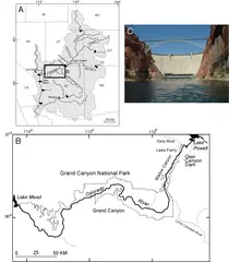
Large dams can greatly alter the physical and biological environments of rivers, by changing the magnitude and timing of flows, sediment transport, and water temperature. One of the most iconic landscapes in the United States, the Colorado River corridor in Grand Canyon National Park, Arizona, is affected in many ways by Glen Canyon Dam (Fig. 1). At 216 m tall, Glen Canyon Dam is one of the largest dams in the country and impounds the second largest reservoir, Lake Powell. Since closure of the dam in 1963, the hydrology, sediment supply, and ecosystem downstream in Marble and Grand Canyon have changed substantially. The dam has reduced the fluvial sediment supply to upper Marble Canyon by about 95%. Because dam operations do not allow the large natural floods that occurred pre-dam, the river does not deposit sediment at elevations that received it regularly before damming, and so many places that received fluvial sedimentation before damming no longer get new sediment. Owing to the loss of floods and sediment supply, and to increased vegetation growth in the absence of floods, the size and number of sandbars in the river corridor downstream of Glen Canyon Dam have decreased substantially.
The loss of sandbars, as well as the decreased sediment content and colder water of the dam-controlled flows, have greatly altered the physical and biological conditions in the Colorado River corridor in Grand Canyon. The loss of sandbars also means there are fewer, and smaller, camping beaches for the tens of thousands of people who raft and hike along the river corridor each year. Controlled floods—higher-than-normal water flows intentionally released from the dam over periods of several days once every few years—have rebuilt sandbars in many places, using sand brought into the canyon by the Paria River tributary a few miles downstream of the dam (Fig. 1). However, because these controlled floods (which occurred in 1996, 2004, 2008, and 2012) were much smaller than typical annual pre-dam floods, the new sandbars erode when normal dam operations resume after the controlled flooding, and the Colorado River sedimentary system remains very different from its natural condition.
The effects of dam operations are not limited only to the river itself, but even influence landforms, sediment, and biological communities above the river's high water line. What happens in the Colorado River affects upland areas because fluvial (river) and aeolian (windblown) sedimentary systems are tightly linked in arid environments. Rivers can serve as both sources and sinks of aeolian sediment, and fluvial sandbars in the Colorado River (and other desert rivers) often supply sand to windblown sand dunes, which form as the wind reworks fluvial sandbars after each flood recedes (Fig. 2). In Marble and Grand Canyon there are many aeolian dune fields, forming an important part of the river corridor's natural landscape. Many dune fields there contain important, irreplaceable cultural artifacts in dozens of archaeological sites hundreds to thousands of years old.
With the loss of floods and fluvial sandbars in the dammed river, the sand supply to many aeolian dunes in Grand Canyon National Park diminished or vanished. Although some areas occasionally receive new windblown sand from sandbars left by artificial, controlled floods (Fig. 2), other aeolian landscapes that used to receive new sand supply from large pre-dam floods now receive essentially no sand. Without windblown sand being deposited on them, dunes become covered by growth of biological communities that don't thrive well in places with more sand supply—biologic soil crust (consisting of cyanobacteria, lichen, mosses, fungi, and algae) and plants. As these biological communities grow and cover sediment-starved dunes, the many upland aeolian landscapes that do not have modern sand supply look and function differently from the few that do have modern sand supply (Fig. 3). The differences between upland areas with and without modern windblown sand supply show that dams can have important effects on the physical and biological environment even far above the high water line. These changes in the dune fields also affect how well archaeological sites are preserved, because many ancient cultural sites depend on aeolian sand to keep them covered and preserved. Without that protective cover of windblown sand, archaeological artifacts can erode and wash downslope during rainstorms. New research is continuing to document and understand landscape processes in Grand Canyon National Park to try to mitigate these and other environmental impacts of dams.
Associated References
- Draut, A.E., 2012, Effects of river regulation on aeolian landscapes, Colorado River, southwestern USA: Journal of Geophysical Research—Earth Surface, v. 117, F2, doi:10.1029/2011JF002329.
- Gloss, S.P., Lovich, J.E., Melis, T.S., eds., 2005, The state of the Colorado River ecosystem in Grand Canyon. U.S. Geological Survey Circular 1282, http://pubs.usgs.gov/circ/1282/.
- Wright, S.A., Schmidt, J.C., Melis, T.S., Topping, D.J., and Rubin, D.M., 2008, Is there enough sand? Evaluating the fate of Grand Canyon sandbars: GSA Today, v. 18, no. 8, doi:10.1130/GSATG12A.1. http://www.gcdamp.gov/index.html
For more information:
Glen Canyon Dam Adaptive Management Program http://www.gcdamp.gov/index.html
USGS Grand Canyon Monitoring and Research Center http://www.gcmrc.gov/