
Soil Morphology
 This material was originally created for
Starting Point:Introductory Geology
This material was originally created for
Starting Point:Introductory Geology and is replicated here as part of the SERC Pedagogic Service.
Summary

Using the Gallery Walk technique, student groups will predict how the soil forming factors of climate, vegetation, topography, parent material, and time contribute to soil characteristics from various locations. Groups will then present their analysis either in an oral or written assignment.
The question: discuss how the following five variables: climate, vegetation, parent material, topography, and time contribute to soil characteristics from various locations. Consider how physical (texture, structure, organic matter content, bulk density, porosity, temperature, or permeability) and how chemical properties (pH, CEC, nutrient content) are impacted.
Learning Goals
Give students experience with synthesizing variables dealing with soil formation and with cooperative learning.
Context for Use
The exercise uses Bloom`s higher order thinking skill of synthesis and requires that students combine climate, vegetation, topography, parent material, and time to explain for soil characteristics in different locations. Students will need a working knowledge of soil's physical (texture, structure, organic matter content, bulk density, porosity, temperature, and permeability) and chemical properties (pH, CEC, and nutrient content) to successfully participate in this exercise. As such, it should be used only after exposure to these concepts, usually midway through the semester. The exercise and ensuing group report outs will take most of a two hour class period.
Description and Teaching Materials
Colored markers, five sheets of poster paper, overhead projector or visualizer for students to use for the report out phase of the exercise. Reproduce the images with a color printer so students can distinguish different profile characteristics, some of which can only be identified through color.
Teaching Notes and Tips

- Read over the Step by Step Instructions section to become thoroughly familiar with the Gallery Walk technique
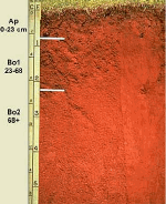
- Obtain images of five different soil types (soil orders) from varying locations. These images could be from your own archive or from those archived at the sites listed in the "References and Resources" section below. One picture should show the soil in a cross section (pictured on the right) the other a surface view (pictured on left) showing landuse. A subsurface and surface perspective will provide groups with needed clues in determining soil characteristics.
- On each poster board fix the two images from each location. Indicate where the images were photographed. Profiles that are too similar will often confuse students so its a good idea to choose soil order images that have maximum contrast in terms of landuse and soil profile characteristics. These sample images (Microsoft Word 1.8MB Nov8 04), larger versions of the thumbnails that appear on this page, could be used for this exercise.
- Introduce the Gallery Walk technique to students the period before students actually participate in the activity. Actually having students walk through a mock Gallery Walk will save time explaining directions later. It is also appropriate to indicate why you are using Gallery Walk (to foster critical thinking and promote cooperative learning).
- On the day of the Gallery Walk, post the images in five locations around the room.
- Before starting, emphasize that correctly linking soil forming factors to soil characteristics depends on more than interpreting images. Field observation and a battery of physical and chemical soil tests would be needed to definitively link soil forming process to soil characteristics.
- Begin the Gallery Walk. For each station groups answer the question how soil forming factors determine a location's soil characteristics. Mention that groups will need to predict what the nature of physical and chemical soil characteristics and why that characteristic appears.
Assessment
Informal assessment will consist of gauging students level of understanding of soil forming factors and soil characteristics as the instructor wanders from group to group. Formal assessment can exist in using an oral report grading matrix to judge the quality of report outs given to the class. As an alternative to the oral report format, students can write their soil characteristics report in the written format and complete it for a group grade. To evaluate the project, see sample assessment rubrics.
References and Resources
- Key to the Soil Taxonomy (more info) from the USDA, descriptions on the characteristics of the 12 major soil orders.
- Field Book for Desribing and Sampling Soils (more info) from the National Soil Survey Center staff is in a PDF format (1.6 MB)and is a `field guide for making or reading soil descriptions and sampling soils as presently practiced in the USA.` The major sections of the document address Site Description, Soil Profile Description, Geomorphology, Geology, Soil Taxonomy. Anyone interested in properly describing soils needs to consult this source. Although primarily written for the college level, the diagrams and descriptions could benefit anyone.
- State Soils Photo Gallery (more info) from USDA, a state soil is represented by a soil series that has special importance to a particular state. To find out about the horizons, color, texture, structure, reaction, consistence, mineral and chemical composition of your state soil go to this site, offered by USDA-NRCS National Soil Survey Center at Iowa State.
- Twelve Soil Orders (more info) the University of Idaho has organized a graphic rich site `...that illustrate the distribution, properties, and use of these 12 soil orders.` This would be a good source for accessing imagery on soils and associated land use.