
The Plate Boundary Fault of the 2011 Tohoku Earthquake: Oceanic Provenance and Earthquake Genesis
Summary
This is one component of the Seismogenic zone Experiment Mini Lessons
This mini lesson provides an example of how stratigraphy influences tectonics, and vice versa. The magnitude 9 Tohoku earthquake slipped a record 50m along a plate boundary fault comprised of extraordinarily weak smectite-rich pelagic clay [Chester et al., 2013; Ujiie et al., 2013, Fulton et al., 2013]. This clay may also have served as a slip surface for numerous large tsunami and tsunamigenic earthquakes along the subduction zone to the northeast, but it facilitated none along the Japan and Izu-Bonin Trenches to the south. During this lesson students will discover the probable reasons for this dichotomy.
Students will be supplied with locations of the Tohoku earthquake ocean drilling site (C0019) and the reference Site (436) as they are back tracked through Pacific Plate motions to their locations of origin. Students will construct the vertical sedimentary sequence that would occur, using Walther's Law (Prothero and Schwab, 1996, p. 329-330).
The student-reconstructed vertical sequence of sedimentary deposits will be compared to that at IODP Site 436. Site 436 includes a conspicuous interval of pelagic clay and is the oceanic reference site for Site C0019 drilled during Exp. 343. Students will compare the vertical succession of sediment lithologies hypothetically accumulated in their backtracked site to those observed at Sites 436, C0019 and others on the oceanic plate incoming to the subduction zone. Students will learn that smooth seafloor correlates with continuity of the pelagic clay layer, whereas, areas of rough seafloor (containing seamounts capped with carbonate and siliceous pelagic sediments) correlate with discontinuity of the pelagic clay layer. They will also learn that large earthquakes and tsunamis occur only in areas of more continuous incoming pelagic clay. Students will be able to speculate on the role of seamounts in interruption of the propagation of seismic slip (e.g. Wang and Bilek, 2011, 2014).
Learning Goals
-
 ×Figure 2. North Pacific Sediment Distribution with incomplete legend. After a general discussion of deep sea sediment types have students match names of sediment types in legend to colored sediment bodies on map
![[creative commons]](/images/creativecommons_16.png) Students will be able to examine a series of stratigraphic columns and predict the likehood of a tsunamigenic earthquake at the Kurile-Japan-Izu Bonin subduction zone.
Students will be able to examine a series of stratigraphic columns and predict the likehood of a tsunamigenic earthquake at the Kurile-Japan-Izu Bonin subduction zone. ×Figure 1. Map of North Pacific Sediments on the subsiding oceanic crust. This map excludes deposits on seamounts and oceanic plateaus. Compiled from Horn et al (1970) and Jenkyns (1986). Backtracked paths of Sites 436 and C0019 are with respect to the rotational axis of the earth.
- Students will be able to describe controls on deep sea sedimentation and, given the lateral movement of plates, be able to predict the stratigraphic sequence that is deposited.
- Students will understand that this is a global scale illustration of Walther's Law, that equates horizontal sediment distribution to vertical stratigraphic sequences http://www.slideshare.net/MOHITRKSINGH/walthers-law-of-correlation-of-facies.
Context for Use
As outlined here, this mini lesson is directed to a sedimentation-stratigraphy course for upper division students; this exercise also could be incorporated into a tectonics course. The lesson can range from 2 to 5 hours, depending on how much is presented to the students versus letting them work together and discover.

- Have students do the backtracking discussed in 2), above, using poles of rotation from [Doubrovine et al., 2012].
- Have students work through the discussion exercise in 6), below, independently; have students use GeoMapApp (with distance/profile tool) to discover the nature of the Pacific Plate seafloor northeast of the Tohoku earthquake (smooth), versus the nature of the seafloor southeast of the Tohoku earthquake zone (rough). They should surmise that the large tsunami earthquakes are associated with areas of continuous pelagic clay and the relative absence of seamounts. Conversely, areas south of the Tohoku earthquake show no large instrumentally recorded earthquakes nor tsunami earthquakes along the Japan or Izu Bonin trenches. This is an area where seamounts are common and they interrupt the continuity of the pelagic clays.
- Have students use subsidence curves for seamounts with respect to calcite compensation depth (varying through time) to develop differing stratigraphic sequences. This could be accomplished using the existing Figure 4 with comparisons to some of the seamount site stratigraphy herein or by consulting the ocean drilling literature for information on sites in the region of Figure 2.
Description and Teaching Materials

Teaching Materials and In-class approaches:
1) Faculty will lead a discussion to help the students understand the distribution of deep sea sediment (Figure 1), given water depth, latitude, and proximity to continents. They will learn that: a) biosiliceous and calcareous deposits occur near the equator, b) red-brown pelagic clay comprises the center of the modern Northern Pacific Ocean, c) biosiliceous sediments occur along continental margins, and d) terrigenous and volcaniclastic sediments are deposited near continental margins and island arcs. For background see (Jenkyns, 1986)
We include a copy of the map in which the legend is modified so the students have to make connections between the names on the legend and the variously colored masses of sediment (Figure 2) ( see Assessment 1). Note that this map only covers the deep water sediments and excludes seamounts and oceanic plateaus that would be above the calcite compensation depth and accumulate carbonate-rich sediments. The sediment distribution map is for the Holocene and we are applying it back as far as the Early Cretaceous.

2) Once students have the sediment types correctly identified on the map they can move Site 436 from its location of origin to where it is today. The backtracking, or determining the previous locations of drill sites, was done in 10 Ma increments using the rotational poles of Doubrovine et al. (2012). Students should note the time that the site resides in each sedimentary environment. Using the following sedimentation rates they can estimate the amount of each sediment type that would accumulate during the > 120 Ma transport of the site through the various oceanic depositional environments. Using the recommended sedimentation rates students can create a model stratigraphic section they can compare to the recovered section at Site 436 (Figure 3).
Recommended Sedimentation Rates (Modified from Jenkyns (1986): Equatorial calcareous and siliceous sediments: 8mm/1000y, Pelagic clay 0.5 mm/1000yr , Transitional and terrigenous sediment 20mm/1000 years.
4) Using the above information students discover that modeled Site 436 accumulates: ~200 m equatorial deposits, ~ 42.5 m of pelagic clay and ~ 300 m transitional and terrigenous deposits. This is a global scale illustration of Walther's Law. Note that the 200 m of presumed equatorial deposits in only partially sampled by Site 436.
This modeled thickness of Site 436 correlates well to the actual section (Figure 3). Note the inclusion of the stratigraphic section from Site 436 in the regional stratigraphic correlation diagram. Compare to the fence diagram of multiple sections cored by ocean drilling in the NW Pacific offshore of the Tohoku earthquake region.
Figure 4 provides a basis for modeling the accumulation of sediments on seamounts or oceanic plateaus. Subsidence curves for seamounts can be plotted on the diagram and sediment accumulations visualized in terms of time spent above and below the calcite compensation depth.

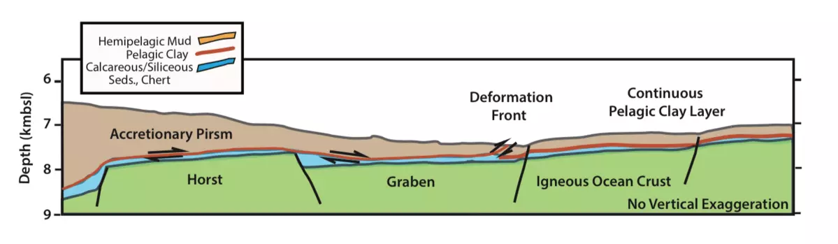
5) Recognize that drill sites northeast of the Tohoku earthquake zone, incoming to the Japan Trench, show continuous pelagic clay layers (Figures 4 and 5). And, note that areas southeast of the Tohoku earthquake zone, incoming to the Japan and Izu Bonin trenches, show a mixture of sections with pelagic clay and without pelagic clay (Figures 5,6,7). The sections without pelagic clay instead include thick sequences of carbonate and chert. Using maps from GeoMapApp http://www.geomapapp.org/ students can recognize that the carbonate-rich sections southeast of the Tohoku earthquake zone lie on seamounts.
6) Instructors lead discussion of observations in (5): A) The incoming seafloor with continuous layers of pelagic clay correlates with subduction zones with large tsunamis (Figure 5). B) Trenches with incoming seamounts and without continuous layers of pelagic clay do not have large earthquakes nor tsunamis. Speculation: seamounts may be important in limiting the progress of tsunamigenic slip on the subduction thrust [Wang and Bilek, 2011].
7) Regional Aspects of Sediment Deposition in the NW Pacific Ocean: Once students are comfortable with the origin of the various stratigraphic units at Site 436, they can look at the broader implications of the process of accumulation of pelagic clay in the NW Pacific.Students should examine the regional map of drilling sites in the NW Pacific (Figure 5) and the two fence diagrams drawn through the area NE and SE of the location of the Tohoku Earthquake. The students should note that the pelagic clay layer appears to be continuous NE of the Tohoku earthquake locality but interrupted by seamounts with dominantly carbonate and siliceous biogenic sediments to the SE.
Moreover the students should note that the area NE of the Tohoku earthquake is characterized by smooth seafloor and an abundance of tsunami and tsunamigenic earthquakes along the subduction megathrust. In contrast the area SE of the Tohoku earthquake lacks instrumentally recorded earthquakes that have produced significant historical tsunamis along the Japan and Izu-Bonin Trench.
Apparently the pelagic clay enables large magnitude slip on subduction thrusts at shallow depths with the production of tsunamis .
Conversely when the continuity of the pelagic clay is interrupted by seamounts covered with carbonate, failure occurs in a more localized fashion without extensive areas of shallow slip and tsunami production (Wang and Bileck 2011, 2014; Mochizuki et al.,1008).
Figures 8 and 9 show conceptual cross sections of 1) the Tohoku Earthquake where the pelagic clay localizes the failure surface over a large distance; and 2) an earthquake just south of the Tohoku rupture zone where a seamount has been associated with a repeating M7 earthquakes that have not produced significant tsunamis (Mochizuki et al.,1008). This example suggests that seamounts interrupt the continuity of the pelagic clay layer and also foster more localized failures that incrementally release strain accumulation.


Assessment
1) Understanding of oceanic sediment distribution: Provide students with Figure 2, the diagram of sediment distribution with the legend not color coded. Ask small groups of students to assign colors to the legend of Figure 2 thereby linking the the verbal descriptions of the legend with the map colors.
2) Additional questions/discussion issues for students: a) How can you use modern sediment distribution to infer sediment accumulation in the Cretaceous? Answer: The assumption is that the oceanic sediment distribution was similar during the Cretaceous and younger times, because sedimentary facies are largely controlled by their position with respect to the rotational axis of the earth. The Pacific was wider in the Mesozoic and Paleogene, but its north-south geometry and relationship to the rotational axis of the earth is presumed to be similar to today. b) What about compaction? The rates given above are for surface sediment accumulation and the thickness would be reduced substantially during consolidation. For example, the pelagic clay section could substantially decrease in thickness when it is buried 300 mbsf.
3) Ask students to compare how the sediment thickness in the modeled Site 436 compares to the real sediment thickness shown in Figure 3.
4) What is Walther's Law (MAYBE MAKE A LINK TO A STRATIGRAPHY BOOK IMAGE OF WALTHER'S LAW.
Ask students to draw a cartoon explaining how oceanic plate motion relates to Walther's law.

Instructor Stories
If you have used this mini-lesson in your course, you can submit your instructor story to help others adopt and adapt this material. Want to discuss GeoPRISMS/MARGINS mini-lessons further with other educators? Join the Community.
References and Resources
- Chester, F. M., et al. (2014), Structure and Composition of the Plate-Boundary Slip Zone for the 2011 Tohoku-Oki Earthquake, Science, 342, 1208-1211, doi:10.1126/science.1243719.
- Davies, T. A., and Gorseline, D. S., 1976, Oceanic sediments and sedimentary processes,in Riley, J. P. a. R. C., ed., Chemical Oceanography, 2nd ed.: London, Academic Press, p. 1-80.
- Doubrovine, P. V., B. Steinberger, and T. H. Torsvik (2012), Absolute plate motions in a reference frame defined by moving hotspots in the Pacific, Atlantic and Indian oceans, Journal of Geophysical Research, 117(B09101), doi:10.1029/2011JB009072.
- Fulton, P. M., et al. (2013), Low Coseismic Friction on the Tohoku-Oki Fault Determined from Temperature Measurements, Science, 342, 1214-1217, doi:10.1126/science.1243641
- GeoMapApp: http://www.geomapapp.org
- Horn, D. R., Horn, B.M.,and Delach, M. N., 1970, Sedimentary provinces of the North Pacific: Geological Society of America Memoir, v. 126, p. 1-21.
- Jenkyns, H. C. (1986), Pelagic Environments, in Sedimentary Environments and Facies, edited by H. G. Reading, pp. 343-397, Blackwell Publications, London.
- Mochizuki, R., T. Yamada, M. Shinohara, Y. Yamanaka, and T. Kanazawa (2008), Weak interplate coupling by seamounts and repeating M~7 earthquakes, Science, 321, 1194-1197, doi:10.1126/Science.1160250.
- Parsons, B., and Sclater, J. G., 1977, An analysis of the variation of ocean floor bathymetry and heat flow with age: Journal of Geophysical Research, v. 82, p.803-827.
- Palike, H., and et al., 2008, A Cenozoic record of the equatorial Pacific carbonate compensation depth: Nature, v. 488, p. 609-614.
- Prothero, D. R., and F. Schwab (1996), Sedimentary Geology, 575 pp., W.H. Freeman and Company, New York.
- Polet, J., and Kanamori (2009), Tsunami Earthquakes, in Encyclopedia of Complexity and Systems Science, edited by R. A. Meyers, pp. 9577-9592, Springer Verlag, doi:10.1007/978-0-387-30440-3_567.
- Ujiie, K., et al. (2013), Low Coseismic Shear Stress on the Tohoku-Oki Megathrust Determined from Laboratory Experiments, Science, 342, 1211-1214, doi:10.1126/science.1243485.
- Van Andel, T., 1975, Mesozoic/Cenozoic calcite compensation depth and the global distribution of calcareous sediments: Earth and Planetary Sciences Letters, v. 26,p. 187-194.
- Wang, K., and S. L. Bilek (2011), Do subducting seamounts generate or stop large earthquakes, Geology, 39, 819-822, doi:10:1130/G31856.1.
- Wang, K., and S. L. Bilek (2014), Invited Review Paper: Fault creep casued by subduction of rough seafloor relief, Tectonophysics, 610, 1-24, doi:http://dx.doi.org/10.1016/j.tecto.2013.11.024.
Background Publication:
Exam question dealing with the general application of Walther's Law in the open ocean setting:
Exam Question Applying Walther's Law in Deep Sea (Acrobat (PDF) 142kB Aug7 14)