Global Topography and Tectonic Plates
Summary
Context
Audience
Beginning students are challenged by basic geography and locating the major plate boundaries, more advanced students by subtle details such as the boundaries of microplates and distinguishing between tectonic and non-tectonic topographic features.
Skills and concepts that students must have mastered
How the activity is situated in the course
Goals
Content/concepts goals for this activity
Learn (or review) the locations of at least some of the major plate boundaries.
Observe how the concepts of plate tectonics and the specific locations and types of plate boundary interactions explains much of the large-scale topography of the Earth (eg the Himalaya, the Red Sea, the Andes; but also the Appalachians as an ancient plate boundary).
Higher order thinking skills goals for this activity
Students (especially advanced students) commonly think that they "know all that" but in fact find that they have trouble locating all the plate boundaries, and especially in connecting different types of boundaries to create fully bounded, independently moving tectonic plates. They then discover, for instance, that individual plate motions are more complex than they thought, because the plate motion cannot be described by a straight line vector on the flat map.
Modern digital topographic maps are images of great beauty, with many many interesting and subtle features, some easily explainable and some not. This exercise works at many levels because it incites curiosity about places and features of the Earth, and encourages students to want to know more about where, why and how.
Other skills goals for this activity
Description and Teaching Materials
Teaching Notes
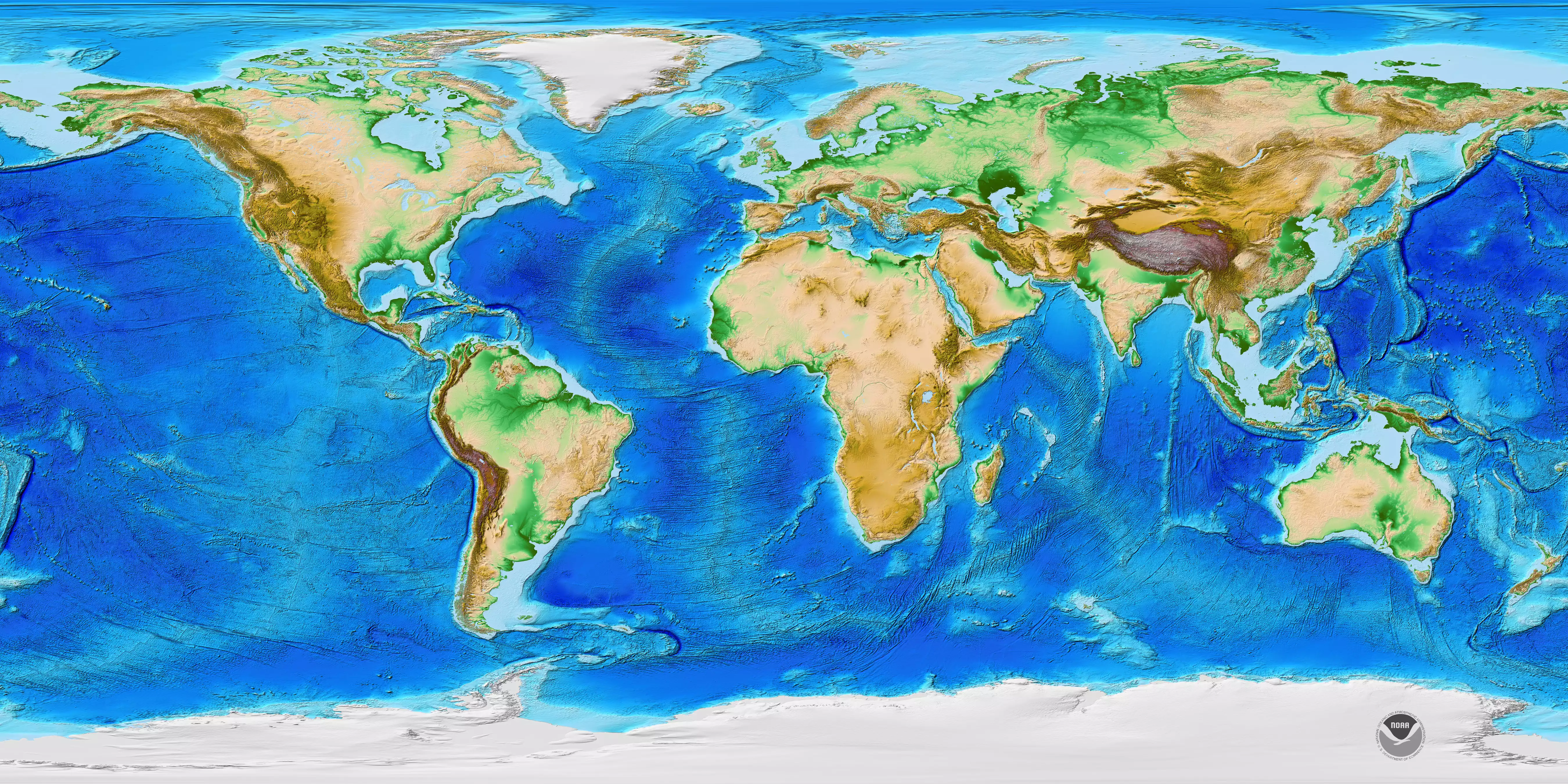
I provide an 11 x 17" or 13 x 19" color digital topographic map for each student, printed on an inkjet printer. (I collect the prints at the end of the exercise for re-use.) There are many of these maps available and they keep getting better. I have posted here a file with a current (very beautiful) version from NOAA at moderate resolution.
I provide tracing paper, peel-off tape, and colored pencils and erasers.
I post in the classroom a large wall map size version of the same digital topographic map, which is great for discussions and exploring fine detail. I provide below a link to a high resolution version that also includes a legend and more information on the data used in making the map.
Sometimes I also post topographic maps of Mars and Venus, and ask students if they see evidence of plate tectonics in the topography of these planets.
I do this as a stand-alone lab exercise, with the map to be completed in class. I of course encourage discussion both between students and with me as interesting questions arise about what they are observing on the map. As stated in the handout, I do not let them look at a map that shows known plate boundaries until after they complete their map.
I always include a set of thought questions that focus students on interesting locations, questions or ideas. These vary depending on the level of the class and the particular map image we are using. I have included here as examples a set of questions that I use for my mid-level majors course in Global Tectonics, and another that I use for Introductory students.
I have used this exercise for many years, during which the quality of available digital topographic maps has continually improved. This has changed the exercise in interesting ways, some plate boundaries and features are much easier to find than they once were but others are more difficult because the added detail creates additional complexity.
Tectonics and Topography Lab Handout for Intro (Microsoft Word 33kB May14 12)

![[reuse info]](/images/information_16.png)
Teaching Notes and Tips
Assessment
References and Resources
http://www.ngdc.noaa.gov/mgg/global/relief/ETOPO1/posters/